
Arcata, California facts for kids
Quick facts for kids
Arcata, California
|
||
|---|---|---|

Arcata Plaza
|
||
|
||

Location within Humboldt County in California
|
||

Arcata, California
Location in California

Arcata, California
Location in the United States
|
||
| Country | United States | |
| State | California | |
| County | Humboldt | |
| Incorporated | February 2, 1858 | |
| Government | ||
| • Type | Council-Manager | |
| Area | ||
| • Total | 11.44 sq mi (29.63 km2) | |
| • Land | 9.42 sq mi (24.40 km2) | |
| • Water | 2.02 sq mi (5.23 km2) 17.25% | |
| Elevation | 23 ft (7 m) | |
| Population
(2020)
|
||
| • Total | 18,857 | |
| • Density | 2,001.59/sq mi (772.83/km2) | |
| Time zone | UTC−8 (Pacific Time Zone) | |
| • Summer (DST) | UTC−7 (PDT) | |
| ZIP codes |
95518, 95521
|
|
| Area code | 707 | |
| FIPS code | 06-02476 | |
| GNIS feature IDs | 277471, 2409723 | |

Arcata is a city in Humboldt County, California, United States. It's located right next to the northern part of Humboldt Bay. In 2020, about 18,857 people lived there.
Arcata was first started in 1850 and was called Union. It officially became a city in 1858 and changed its name to Arcata in 1860. The city is about 280 miles (450 km) north of San Francisco. It's also home to California State Polytechnic University, Humboldt, a big university.
Contents
History
Native American History
The Wiyot people and Yurok people lived in this area long before Europeans arrived, and they still live there today. The Wiyot people called the place where Arcata now stands "Kori." The name "Arcata" comes from the Yurok word oket'oh, which means "where there is a lagoon." This refers to Humboldt Bay.
The Wiyot people's traditional land stretched from the Little River in the north down to the lower Eel River. The Yurok people's land was from the Mad River north to the Klamath River. Today, Arcata is where the Big Lagoon Rancheria tribe has its main office.
In 1860, there was a very sad event where many Wiyot people were killed by white settlers in and around Humboldt Bay. This included Duluwat Island, which was a very important place for them.
Early European Settlement

The Spanish claimed this area, but they never built permanent settlements. The first lasting settlements began after California became part of the United States. Arcata was first settled in 1850 and was called Union. It was created as a port and a supply center for the gold mines in the mountains to the east. For a short time, it was even the county seat.
By the late 1850s, the focus shifted from gold to redwood timber. Eureka became the main city on the bay because it had a better harbor. The post office in Union opened in 1852, and the town's name changed to Arcata in 1860.
In 1886, the people of Arcata decided to ask their Chinese residents to leave the city. This was a difficult time, and a resolution was passed to remove all Chinese settlements from Arcata and nearby areas.
Many old photos and stories about early settler families in Arcata are kept at California State Polytechnic University, Humboldt. These collections also show important community events, like graduations at Arcata High School and gatherings at the Arcata Plaza.
Recent Times
Since the 1970s, Arcata has been home to several companies that make outdoor gear. For example, Yakima Racks, a company that makes car racks and bike accessories, was based here for many years. Moonstone Mountaineering, which made sleeping bags and waterproof gear, started here too.
Kokatat, a company that makes waterproof clothing for water sports like kayaking, is still headquartered in Arcata. They even make gear for the US Coast Guard and Navy SEALs! Another company, Wing Inflatables, makes inflatable boats used by river tours and government agencies like NASA.
In 1989, Arcata voters passed the Nuclear-Weapon-Free Zone Act. This law stops work on nuclear weapons, and their storage or transport, within the city. In 2010, the city council passed a rule about panhandling, which limits it near businesses.
Geography

Arcata covers about 11 square miles (28 square kilometers). Most of this is land, but about 1.9 square miles (5 square kilometers) is water.
The city has several main areas for shopping and public life, like Downtown/Plaza, Northtown, and Valley West. There are also many smaller neighborhoods within Arcata. One special place is the Arcata Marsh, a nature preserve by the bay.
Climate
Arcata has a cool-summer Mediterranean climate. This means it has mild, wet winters and cool, dry summers. The nearby Pacific Ocean and Humboldt Bay keep the weather much cooler than other places with similar climates.
On average, Arcata gets about 40 to 50 inches (1000 to 1270 mm) of rain each year. Most of the rain falls from October to May. Summers are often foggy, with temperatures usually in the 50s and low 60s Fahrenheit (10-17 Celsius). Just a few miles inland, it can be much warmer in the summer.
Winter temperatures are usually in the 40s and 50s Fahrenheit (4-13 Celsius). It rarely gets below 30°F (-1°C) in winter or above 72°F (22°C) in summer.
Population
| Historical population | |||
|---|---|---|---|
| Census | Pop. | %± | |
| 1880 | 702 | — | |
| 1890 | 962 | 37.0% | |
| 1900 | 952 | −1.0% | |
| 1910 | 1,121 | 17.8% | |
| 1920 | 1,486 | 32.6% | |
| 1930 | 1,709 | 15.0% | |
| 1940 | 1,855 | 8.5% | |
| 1950 | 3,729 | 101.0% | |
| 1960 | 5,235 | 40.4% | |
| 1970 | 8,985 | 71.6% | |
| 1980 | 12,850 | 43.0% | |
| 1990 | 15,197 | 18.3% | |
| 2000 | 16,651 | 9.6% | |
| 2010 | 17,231 | 3.5% | |
| 2020 | 18,857 | 9.4% | |
| U.S. Decennial Census | |||


Population Changes
Like many towns that relied on industries like timber or mining, Arcata's population changed over time. When the timber industry was at its peak in 1950, Arcata had about 3,729 people. After the timber industry slowed down in 1955, the population grew to 5,235 by 1960. This was partly due to more young people moving to the area.
Recent Population Data
In 2010, Arcata had a population of 17,231 people. Most residents were White (81.8%), followed by Hispanic or Latino (11.6%). People of two or more races made up 6.6% of the population.
About 12.6% of the population was under 18 years old, and a large group (34.2%) was between 18 and 24 years old. This shows that many young adults, likely students, live in Arcata. The average age in Arcata was 26.1 years.
In 2018, the estimated population of Arcata was 18,989. About 5,698 of these were students at California State Polytechnic University, Humboldt. The average age of citizens in 2019 was 26.4 years.
| Racial and ethnic composition | 2000 | 2010 | 2020 |
|---|---|---|---|
| White (non-Hispanic) | 81.3% | 76.33% | 64.41% |
| Hispanic or Latino (of any race) | 7.22% | 11.61% | 19.83% |
| Two or more races (non-Hispanic) | 4.25% | 4.99% | 7.49% |
| Black or African American (non-Hispanic) | 1.48% | 1.87% | 2.54% |
| Asian (non-Hispanic) | 2.23% | 2.52% | 2.44% |
| Native American (non-Hispanic) | 2.31% | 1.87% | 2.08% |
| Other (non-Hispanic) | 1.03% | 0.62% | 0.97% |
| Pacific Islander (non-Hispanic) | 0.18% | 0.18% | 0.24% |
Arts and Culture

The heart of Arcata is the Plaza. In the 1850s, this was where goods were loaded onto mule trains to go to the gold mines. Today, the Plaza has a green lawn and beautiful flowers. It's surrounded by shops, cafes, restaurants, and places with live music.
The Plaza is also where the biggest farmers' market in Humboldt County takes place. It hosts many local events like the Fourth of July celebrations, the Arcata Main Street Oyster Festival, the start of the Kinetic Sculpture Race, and the North Country Fair. The North Country Fair Samba Parade has been a favorite since 1986.
For many years, a statue of President William McKinley stood in the center of the Plaza. Since the 1970s, there have been different opinions about the statue. Some people felt it represented harmful policies towards Native Americans, while others thought it was an important part of Arcata's history. In 2018, the Arcata City Council voted to remove the statue. It was moved in 2019 to the William McKinley Presidential Library and Museum in Canton, Ohio.

Arcata also has many beautiful old Victorian buildings, and many of them have been restored. The Wiyot people, who originally lived here, called the Plaza "Goad-la-nah," meaning "the land a little above the water."
Arcata's Minor Theater is one of the oldest movie theaters in the United States that is still open.
Events

Arcata hosts many fun events throughout the year:
- Kinetic Sculpture Race
- North Country Fair
- North Country Fair Samba Parade
- Godwit Days (a bird festival in April)
- Arts! Arcata (an art walk every second Friday)
- Arcata Main Street Oyster Festival
- Fourth of July Jubilee
- Saturday's Farmer's Market
- 12 Hours of Humboldt (a mountain bike race)
- "I" Street Block Party (a summer event for Arcata's sister city)
- Pastels on the Plaza
Sports
Arcata is home to the Humboldt Crabs, which is the longest-running semi-pro baseball team in the nation. They have played every season since 1945, except for 2020 due to the COVID-19 pandemic.
Parks and Recreation
The Arcata Marsh is a special place with freshwater and saltwater ponds. It was built in 1979 to help clean the city's wastewater using natural marsh systems. It has won many awards for its innovative design. The marsh is a popular spot for biking, bird watching, and jogging.
The city also owns about 2,100 acres (850 hectares) of forest land, including the Arcata Community Forest. This forest was bought by the city in 1955 to protect its water supply. It was the first city-owned community forest in California. It's used for recreation, education, and sustainable timber harvesting. The Arcata Community Forest was the first city forest in the U.S. to be certified for good forest management in 1998.
Education

Arcata is where California State Polytechnic University, Humboldt is located. It's the northernmost campus in the California State University system. With so many students, Arcata is a classic "college town." The university is about 0.8 miles (1.3 km) from the city center.
The main public high school in Arcata is Arcata High School. It has about 827 students and offers many programs, including advanced classes and student clubs.
Media
The Eureka Times-Standard is the main daily newspaper that covers Arcata. There are also local weekly papers like the Mad River Union. The Northcoast Environmental Center in Arcata publishes Econews, a monthly journal.
California State Polytechnic University, Humboldt has student-run media, including a weekly newspaper called The Lumberjack, a magazine called Osprey, and a bilingual newspaper called El Leñador. Arcata is also home to the university's student radio station, KRFH 105.1 FM.
Transportation
Roads
U.S. Route 101 runs through Arcata, going north and south. State Route 299 connects to Highway 101 in Arcata and goes east towards other towns like Redding.
The highways connecting Arcata to other areas outside Humboldt County often have winding roads through mountains. These roads can sometimes close during heavy rain or wind, which might mean taking long detours. Even though Arcata is in California, it's considered one of the more remote places on the continental US west coast. Arcata also has several paths for cycling.
Public Transit
Redwood Transit System (RTS) provides public bus transportation throughout Humboldt County, with several stops in Arcata. The Arcata and Mad River Transit Service (AMRTS) is a local bus service for Arcata and Sunny Brae.
The Arcata Transit Center is the main place for bus services in Arcata, including Amtrak Thruway buses. These buses connect Arcata to Martinez and other stops along Highway 101.
Air Travel
The closest airport is the Arcata-Eureka Airport in McKinleyville. This airport was built during World War II to test ways to clear fog. It's known for being one of the foggiest airports in the world, which often causes flight delays or cancellations. Sometimes, flights have to land in other cities like Redding, California.
Waterways
There used to be a deep-water port in Arcata. In 1854, a company built a long pier and railroad into Arcata Bay to reach deeper water. This allowed ships to dock there. This railroad eventually became the Arcata and Mad River Railroad. Today, Arcata's old pier is gone, and the bay becomes a large mud flat at low tide, making it hard for boats.
Notable people
- Edward N. Ament (1860–1949) – mayor of Berkeley, California
- Christopher Buckley (b. 1948) – poet
- Raymond Carver (1938–1988) – writer
- Wesley Chesbro (b. 1951) – politician
- Don Durdan (1920–1971) – professional American football and basketball player
- Robert A. Gearheart (b. 1938) – Cal Poly Humboldt professor
- Steven Hackett (b. 1960) – economist, Cal Poly Humboldt professor
- Bret Harte (1836–1902) – writer
- Dan Hauser (b. 1942) – politician
- Garth Iorg (b. 1954) – professional baseball player
- Christa Johnson (b. 1958) – professional golfer
- Naomi Lang (b. 1978) – Olympic ice dancer
- Tim McKay (1947–2006) – environmentalist
- Nate Quarry (b. 1972) – Mixed Martial Arts fighter
- Eric Rofes (1954–2006) – writer
- Steve Sillett (b. 1968) – botanist
- Greg Stafford (1948–2018) – game designer
- James Allen Taylor (b. 1937) – decorated Army officer
- Willi Unsoeld (1926–1979) – mountaineer
- Don Van Vliet (aka Captain Beefheart) (1941–2010) – artist
- Gary Wilson (b. 1970) – professional baseball pitcher
- Pamela Wu (b. 1974) – newsanchor
Sister city
Images for kids
-
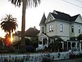
Victorian architecture in Arcata

See also
 In Spanish: Arcata (California) para niños
