Lewiston, California facts for kids
Quick facts for kids
Lewiston
|
|
|---|---|

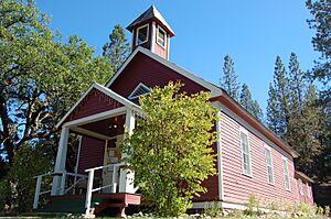
Lewiston Schoolhouse, in the Lewiston Historic District, is now a library
|
|

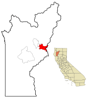
Location in Trinity County and the state of California
|
|
| Country | United States |
| State | California |
| County | Trinity |
| Area | |
| • Total | 20.009 sq mi (51.824 km2) |
| • Land | 20.009 sq mi (51.824 km2) |
| • Water | 0 sq mi (0 km2) 0% |
| Elevation | 1,814 ft (553 m) |
| Population
(2020)
|
|
| • Total | 1,222 |
| • Density | 61.073/sq mi (23.580/km2) |
| Time zone | UTC-8 (Pacific (PST)) |
| • Summer (DST) | UTC-7 (PDT) |
| ZIP code |
96052
|
| Area code(s) | 530 |
| FIPS code | 06-41278 |
| GNIS feature ID | 0277538 |
Lewiston is a small community in Trinity County, California, United States. It is known as a census-designated place (CDP). This means it is a community that is not officially a city or town, but its population is counted by the government.
In 2020, the population of Lewiston was 1,222 people. This was a small increase from 1,193 people counted in 2010.
Contents
Geography of Lewiston
Lewiston is located in northern California. Its exact coordinates are 40.699213 degrees north and -122.810684 degrees west.
The United States Census Bureau says that Lewiston covers a total area of about 20 square miles (51.8 square kilometers). All of this area is land.
What is the Climate Like in Lewiston?
Lewiston has a type of weather called a hot-summer Mediterranean climate. This is sometimes called "Csa" on climate maps.
This means Lewiston has:
- Hot summers
- Cool winters
- Big changes in temperature between day and night
The table below shows more details about the weather in Lewiston. It includes average temperatures and rainfall.
| Climate data for Trinity River Hatchery, California (normals 1981-2010)(extremes 1921-2020) | |||||||||||||
|---|---|---|---|---|---|---|---|---|---|---|---|---|---|
| Month | Jan | Feb | Mar | Apr | May | Jun | Jul | Aug | Sep | Oct | Nov | Dec | Year |
| Record high °F (°C) | 65.0 (18.3) |
76.0 (24.4) |
84.0 (28.9) |
94.0 (34.4) |
101.0 (38.3) |
109.0 (42.8) |
113.0 (45.0) |
113.0 (45.0) |
108.0 (42.2) |
99.0 (37.2) |
83.0 (28.3) |
67.0 (19.4) |
113.0 (45.0) |
| Mean maximum °F (°C) | 57.0 (13.9) |
67.0 (19.4) |
74.0 (23.3) |
85.0 (29.4) |
92.0 (33.3) |
99.0 (37.2) |
104.0 (40.0) |
104.0 (40.0) |
99.0 (37.2) |
89.0 (31.7) |
70.0 (21.1) |
57.0 (13.9) |
106.0 (41.1) |
| Mean daily maximum °F (°C) | 48.0 (8.9) |
53.8 (12.1) |
59.9 (15.5) |
66.1 (18.9) |
75.4 (24.1) |
84.2 (29.0) |
93.0 (33.9) |
91.0 (32.8) |
86.0 (30.0) |
73.4 (23.0) |
55.4 (13.0) |
46.6 (8.1) |
69.5 (20.8) |
| Daily mean °F (°C) | 40.1 (4.5) |
43.2 (6.2) |
47.7 (8.7) |
51.7 (10.9) |
59.1 (15.1) |
66.2 (19.0) |
72.7 (22.6) |
71.3 (21.8) |
65.4 (18.6) |
56.1 (13.4) |
45.5 (7.5) |
39.2 (4.0) |
54.8 (12.7) |
| Mean daily minimum °F (°C) | 32.3 (0.2) |
32.7 (0.4) |
34.9 (1.6) |
37.3 (2.9) |
42.9 (6.1) |
48.2 (9.0) |
52.5 (11.4) |
50.8 (10.4) |
44.9 (7.2) |
38.8 (3.8) |
35.5 (1.9) |
31.8 (−0.1) |
40.2 (4.6) |
| Mean minimum °F (°C) | 24.0 (−4.4) |
24.0 (−4.4) |
27.0 (−2.8) |
29.0 (−1.7) |
33.0 (0.6) |
39.0 (3.9) |
45.0 (7.2) |
44.0 (6.7) |
37.0 (2.8) |
30.0 (−1.1) |
26.0 (−3.3) |
23.0 (−5.0) |
19.0 (−7.2) |
| Record low °F (°C) | 12.0 (−11.1) |
10.0 (−12.2) |
20.0 (−6.7) |
23.0 (−5.0) |
27.0 (−2.8) |
33.0 (0.6) |
37.0 (2.8) |
38.0 (3.3) |
32.0 (0.0) |
20.0 (−6.7) |
15.0 (−9.4) |
4.0 (−15.6) |
4.0 (−15.6) |
| Average precipitation inches (mm) | 5.68 (144) |
5.07 (129) |
4.21 (107) |
2.31 (59) |
1.74 (44) |
0.80 (20) |
0.17 (4.3) |
0.22 (5.6) |
0.60 (15) |
1.90 (48) |
4.37 (111) |
6.39 (162) |
33.46 (850) |
| Average snowfall inches (cm) | 1.6 (4.1) |
1.6 (4.1) |
0.7 (1.8) |
0 (0) |
0 (0) |
0 (0) |
0 (0) |
0 (0) |
0 (0) |
0 (0) |
0.5 (1.3) |
1.9 (4.8) |
6.8 (17) |
| Average precipitation days (≥ 0.01 in) | 14.3 | 12.4 | 12.1 | 8.6 | 6.6 | 3.1 | 1.2 | 1.3 | 2.4 | 5.7 | 11.4 | 14.1 | 93.2 |
| Source: NOAA | |||||||||||||
History of Lewiston
Lewiston got its name from Benjamin Franklin Lewis. He was the adopted son of Tom Palmer, who founded the town.
Tom Palmer and Benjamin Lewis ran a gold mining operation. This was during the early days of the California Gold Rush. They worked on the Trinity River.
A post office has been open in Lewiston since 1854.
Population and People in Lewiston
Lewiston's population has changed over the years.
| Historical population | |||
|---|---|---|---|
| Census | Pop. | %± | |
| 2000 | 1,305 | — | |
| 2010 | 1,193 | −8.6% | |
| 2020 | 1,222 | 2.4% | |
| U.S. Decennial Census | |||
In 2010, the population was 1,193 people. Most people were White (90%). There were also Native American, African American, Asian, and Pacific Islander residents. About 6.5% of the population was Hispanic or Latino.
The population was spread out in terms of age:
- 16.9% were under 18 years old.
- 21.5% were 65 years or older.
- The average age was about 51.4 years.
In 2000, the population was 1,305 people. The racial makeup was similar to 2010. About 24.5% of the people were under 18. About 17.9% were 65 or older.
Fun Places to Visit in Lewiston
Lewiston has several interesting places to explore:
- Trinity Dam: This is home to California's third largest reservoir. A reservoir is a large lake used to store water.
- Trinity River: The Trinity River flows right through Lewiston. You can see it under the Old Lewiston Bridge.
- Lewiston Lake: This lake is great for fishing and camping. It's located along Trinity Dam Boulevard. The water is very cold, so it's not usually used for swimming.
- Trinity Lake: This lake is just above Lewiston Lake and Trinity Dam. It's a popular spot in the summer for:
- Fishing
- Camping
- Boating
- Swimming
See also
 In Spanish: Lewiston (California) para niños
 | Sharif Bey |
 | Hale Woodruff |
 | Richmond Barthé |
 | Purvis Young |


