Thomes Creek facts for kids
Quick facts for kids Thomes Creek |
|
|---|---|

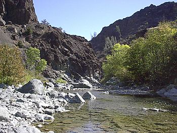
Thomes Creek near The Gorge
|
|
|
Location of mouth of Thomes Creek in California
|
|
| Country | United States |
| State | California |
| Physical characteristics | |
| Main source | Kingsley Lake Mendocino National Forest, Tehama County 6,460 ft (1,970 m) 40°02′00″N 122°56′30″W / 40.03333°N 122.94167°W |
| River mouth | Sacramento River near Tehama, Tehama County 184 ft (56 m) 39°59′26″N 122°05′46″W / 39.99056°N 122.09611°W |
| Length | 62 mi (100 km) |
| Basin features | |
| Basin size | 300 sq mi (780 km2) |
Thomes Creek is an important waterway in Northern California. It starts in the Coast Ranges mountains. The creek flows east for about 62 miles (100 km). It eventually joins the large Sacramento River. This meeting point is near Tehama in Tehama County.
Thomes Creek is a stream that changes a lot with the seasons. It drains a mostly rural area of about 300 square miles (780 km2). There are no big dams on the creek. However, some small amounts of water are taken for farms and homes. The water quality in Thomes Creek is generally very good. If you like whitewater sports, the upper 22 miles (35 km) of Thomes Creek are known for being very challenging for kayaking and rafting.
Contents
Why is it Called Thomes Creek?
Thomes Creek is named after Robert Hasty Thomes. He was a pioneer who came to this area in the 1840s. Over time, people often mispronounced or misspelled his name. This led to other names being used, like "Thomas Creek" or "Toms Creek."
Where is Thomes Creek Located?
Thomes Creek begins at Kingsley Lake. This is a small pond located high up at 6,460 feet (1,970 m) in the Mendocino National Forest. The lake sits between two peaks: Solomon Peak and Sugarloaf Mountain. The creek flows south through a deep valley. After about 10 miles (16 km), it turns east.
It then goes through a narrow area called Thomes Gorge, or "The Gorge." After leaving the mountains near Paskenta, it flows east-northeast. It passes through areas like Henleyville and Tehama. Finally, it joins the Sacramento River.
The Creek's Journey and Surroundings
The upper part of the Thomes Creek area is rugged and mountainous. This means it can have lots of floods and landslides. The highest point in the entire area that drains into the creek is Mount Linn. This mountain is 8,081 feet (2,463 m) tall.
The lower part of the creek flows over a wide bed of rocks and gravel. Because of the weather, this lower part often dries up in the summer. Most of the water comes from rain. However, snow does fall in the mountains above 5,000 feet (1,500 m). The lowlands get about 20 inches (510 mm) of rain each year. The mountains can get much more, up to 70 to 80 inches (1,800 to 2,000 mm).
The water quality in Thomes Creek is good. However, it has been affected by erosion. Erosion is when soil and rock are worn away. This happens naturally because of the type of rock in the Coast Ranges. But human activities like ranching, logging, farming, and mining also cause erosion.
How Much Water Flows in Thomes Creek?
The U.S. Geological Survey measured the water flow of Thomes Creek. They did this near Paskenta between 1920 and 1996. On average, the creek flowed at 295.4 cubic feet per second (8.36 m3/s) each year.
The amount of water changes a lot during the year. In February, the average flow was 706 cubic feet per second (20.0 m3/s). In October, it was much lower, at 5.1 cubic feet per second (0.14 m3/s). The highest flow ever recorded was 37,800 cubic feet per second (1,070 m3/s). This happened on December 22, 1964, during a very big flood.
Fish and Wildlife in Thomes Creek
Thomes Creek is home to many different kinds of fish. A study in 1982 found as many as 22 fish species. Some of these include Sacramento pikeminnow, Sacramento sucker, and California roach.
The creek is also important for steelhead trout. These fish travel up the creek from the ocean. There are also rainbow trout that live in the creek all the time. These rainbow trout live above waterfalls in "The Gorge." These waterfalls make it harder for some fish to swim further upstream. Spring-run chinook salmon also live in Thomes Creek.
 | Claudette Colvin |
 | Myrlie Evers-Williams |
 | Alberta Odell Jones |


