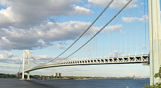
Verrazano-Narrows Bridge facts for kids
Quick facts for kids Verrazzano-Narrows Bridge |
|
|---|---|
 |
|
| Coordinates | 40°36′25″N 74°02′35″W / 40.607°N 74.043°W |
| Carries | 13 lanes of (7 lanes on upper level: 3 in each direction, 1 reversible HOV lane; 6 lanes on lower level) |
| Crosses | The Narrows |
| Locale | New York City (Staten Island–Brooklyn), New York, U.S. |
| Other name(s) | Verrazano-Narrows Bridge Verrazzano Bridge Narrows Bridge |
| Maintained by | MTA Bridges and Tunnels |
| Characteristics | |
| Total length | 13,700 ft (4,176 m) |
| Width | 103 ft (31 m) |
| Height | 649.68 ft (198 m) |
| Longest span | 4,260 ft (1,298 m) |
| Clearance above | 15 ft (4.57 m) (upper level) 14.4 ft (4.39 m) (lower level) |
| Clearance below | 228 ft (69.5 m) at mean high water |
| History | |
| Designer | Othmar Ammann |
| Construction begin | August 13, 1959 |
| Opened | November 21, 1964 (upper level) June 28, 1969 (lower level) |
| Statistics | |
| Daily traffic | 215,000 (2019) |
| Toll | As of December 1, 2020[update]:
|
The Verrazzano-Narrows Bridge is a famous suspension bridge in New York City. It connects two important parts of the city: Staten Island and Brooklyn. This bridge crosses a narrow waterway called The Narrows, which is a busy entrance to New York Harbor.
The bridge is named after an Italian explorer, Giovanni da Verrazzano. He was the first European to sail into New York Harbor back in 1524.
When the Verrazzano-Narrows Bridge was finished, it was the longest suspension bridge in the whole world! It held this record for many years until 1981.
Contents
Building the Verrazzano-Narrows Bridge
Building such a huge bridge was a big project! Construction started on August 13, 1959. It took many years and a lot of hard work to complete.
Who Designed the Bridge?
The main designer of the Verrazzano-Narrows Bridge was a famous engineer named Othmar Ammann. He designed many other important bridges in New York City, like the George Washington Bridge.
How Long Did it Take?
The upper level of the bridge opened first, on November 21, 1964. This allowed cars to start using it. The lower level was finished later, opening on June 28, 1969. This added even more lanes for traffic.
Bridge Features and Size
The Verrazzano-Narrows Bridge is truly massive. It has two levels for cars, carrying a total of 13 lanes of Interstate 278.
How Big is It?
- Length: The entire bridge is about 13,700 feet (4,176 meters) long. That's over 2.5 miles!
- Main Span: The longest part of the bridge between its two main towers is 4,260 feet (1,298 meters). This was the longest in the world for a long time.
- Height: The towers of the bridge stand very tall, about 649.68 feet (198 meters) high. That's taller than a 60-story building!
- Clearance: Ships need to pass underneath the bridge. There is about 228 feet (69.5 meters) of space between the water and the bridge's lower deck. This allows even very large ships, like cruise liners, to pass safely.
How Many Cars Use It?
In 2019, about 215,000 vehicles crossed the Verrazzano-Narrows Bridge every single day! That's a lot of cars, trucks, and buses.
Images for kids
-
View of the Verrazzano-Narrows Bridge from Upper New York Bay, with Coney Island in the distance
-
Construction of the suspension towers, seen in 1962, with the ocean liner RMS Queen Mary transiting the Narrows in background
-
Coast Guard on patrol in Upper New York Bay. In the background, the Verrazzano-Narrows Bridge spans the Narrows between Brooklyn (left) and Staten Island (right).
See also
 In Spanish: Puente de Verrazano-Narrows para niños
 | Precious Adams |
 | Lauren Anderson |
 | Janet Collins |


