
Alameda (island) facts for kids

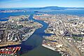
Aerial view of the north end of Alameda Island (left), with Oakland on the right and San Francisco in the background
|
|
| Geography | |
|---|---|
| Location | San Francisco Bay, California |
| Coordinates | 37°46′36″N 122°16′40″W / 37.77667°N 122.27778°W |
| Coastline | 9.25 km (5.748 mi) |
| Administration | |
|
United States
|
|
| State | |
Alameda Island is a cool island located in the San Francisco Bay in California. It sits next to Oakland and across the bay from San Francisco. Most of the city of Alameda is found right here on the island.
A long time ago, there was a big Naval Air Station Alameda on the island. It was a base for navy planes, but it's not used anymore. The island wasn't always an island! It used to be a peninsula connected to Oakland. Now, the Oakland Estuary separates it from the mainland. You can get to Alameda Island from the mainland using four bridges: the Park Street Bridge, Fruitvale Bridge, High Street Bridge, and Bay Farm Island Bridge. There are also two underwater tunnels, called the Posey and Webster Street tubes, that connect Oakland to the island.
Island History

Alameda Island used to be a peninsula connected to Oakland. A lot of it was low and marshy, like a swamp. But on higher ground, there was a huge forest of oak trees. This was one of the biggest oak forests in the world! Because of these trees, the area was called Encinal. This is a Spanish word meaning "oak grove."
Later, in 1853, people voted to name the area Alameda. This Spanish word means "grove of poplar trees" or "tree-lined avenue."
Early Inhabitants
When Spanish explorers arrived in the late 1700s, the Ohlone tribe lived here. The peninsula became part of a very large land area called Rancho San Antonio. The King of Spain gave this land to a person named Luis Peralta. Later, when Mexico became independent from Spain, they confirmed this land grant.
Over time, the area was also known as Bolsa de Encinal or Encinal de San Antonio.
How the Island Was Formed
Alameda became a true island in 1902. Workers dug a canal on the south side of the land. This canal helped keep the estuary (the water channel) to the north clear for ships. More land was added around the island over time. This continued until the island even crossed into San Francisco's territory!
Today, Alameda Island has many beautiful Victorian homes. These houses were built in the late 1800s and early 1900s. Almost the entire island has been developed with buildings and homes. You can also find several miles of beaches along the south side of the island, which are great for visiting!
Images for kids
-
Aerial view of the north end of Alameda Island (left), with Oakland on the right and San Francisco in the background
-
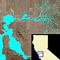
False color image of San Francisco Bay, showing Alameda Island as the largest island in the bay, just off the mainland of the East Bay, across from the end of the San Francisco Peninsula.
