
Petaluma River facts for kids
Quick facts for kids Petaluma River |
|
|---|---|

The river flowing through Petaluma. View is to the southeast.
|
|
| Country | United States |
| State | California |
| Region | Sonoma and Marin counties |
| City | Petaluma, California |
| Physical characteristics | |
| Main source | 1.5 mi (2 km) southwest of Cotati, California 332 ft (101 m) 38°18′18″N 122°43′3″W / 38.30500°N 122.71750°W |
| River mouth | San Pablo Bay 5 mi (8 km) east of Novato, California 0 ft (0 m) 38°6′38″N 122°29′15″W / 38.11056°N 122.48750°W |
| Length | 18 mi (29 km) |
| Basin features | |
| Tributaries |
|
The Petaluma River is a waterway that flows through Sonoma and Marin counties in California. For most of its length, it acts like a "tidal slough." This means it's a narrow channel where the water level changes with the ocean tides.
The river begins southwest of Cotati. It flows south through the old part of Petaluma. Here, boats can travel on the water. The river then continues for about 10 mi (16 km) through tidal marshes. Finally, it empties into the northwest part of San Pablo Bay.
River History: The Story of Petaluma
The name "Petaluma" might come from the Miwok language. The Miwok people lived in Sonoma County for over 2,500 years. Their words pe’ta (flat) and luma (back) could be the source. Petaluma was also the name of a village on a small hill near the creek. This village was northeast of where the city of Petaluma is today.
The first time the Petaluma River was explored by Europeans was in October 1776. Captain Fernando Quiros led a Spanish expedition. While others gathered building materials for the new Presidio of San Francisco and Mission San Francisco de Asís, Quiros tried to sail from San Pablo Bay to Bodega Bay. He was not successful.
Petaluma River Watershed: Where the Water Flows
The Petaluma River Watershed is an area of land where all the rain and water drain into the Petaluma River. It's located in southern Sonoma County and a small part of northeastern Marin County. This watershed covers about 146 square miles (380 km2).
The watershed is about 19 miles (31 km) long and 13 miles (21 km) wide. The City of Petaluma is located near its center. Sonoma Mountain is the highest point in the watershed, standing at 2,295 feet (700 m). Water from its western slopes flows into the Petaluma River. This happens through smaller streams called tributaries. Some of these are Lichau Creek, Lynch Creek, Washington Creek, and Adobe Creek.
The lower 12 miles (19 km) of the Petaluma River flows through the Petaluma Marsh. This marsh is the largest remaining salt marsh in San Pablo Bay. It covers about 5,000 acres (20 km2). Around the marsh, there are also about 7,000 acres (28 km2) of reclaimed wetlands.
West of Lakeville, the river meets San Antonio Creek. At this point, the Petaluma River becomes the border between Marin County and Sonoma County. The river then flows under California State Route 37 at Green Point. It enters northwest San Pablo Bay just north of Petaluma Point.
The river's source is over 300 ft (100 m) above sea level. However, it drops to 50 ft (15 m) very quickly, within about 0.4 mi (600 m). The river is fully tidal for 11 mi (18 km) from its mouth. This shows that it has a very slight slope through the marshes below Petaluma. The United States Army Corps of Engineers regularly dredges this part of the river. This keeps it navigable for boats carrying gravel and for pleasure boats.
River Ecology: Plants and Animals
The Petaluma River Watershed is home to many important animals. Some of these are federally endangered. This means they are at risk of disappearing forever.
- Endangered Animals:
- The salt marsh harvest mouse (Reithrodontomys raviventris)
- The Ridgway's Rail (Rallus obsoletus)
- The North American River Otter (Lontra canadensis)
- Endangered Plants:
- Soft bird’s-beak (Cordylanthus mollis ssp. mollis)
- Baker’s stickyseed (Blennosperma bakeri)
- Burke’s goldfields (Lasthenia burkei)
- Showy Indian clover (Trifolium amoenum)
- Sebastopol meadowfoam (Limnanthes vinculans)
Steelhead (Oncorhyncus mykiss) are a type of fish that live in the Petaluma River watershed. These fish are wild, not from a fish farm. They are born and grow up in the river. Chinook salmon (Oncorhynchus tshawytscha) are also seen in the main part of the Petaluma River. Students from Casa Grande High School have even seen Chinook salmon near the turning basin, where Lynch Creek joins the river. These students built a salmon hatchery in 1993. In 2002, 74 Chinook salmon returned to lay their eggs in the Adobe Creek tributary.
Habitat and Pollution: Keeping the River Healthy
The marshes along the Petaluma River are very important. They provide a home for many wild animals and act as a nursery for young fish. However, since the mid-1850s, when many people started moving to the area, the water quality has gotten worse. This is partly due to too much grazing by animals and other farming activities.
- Pollutants in the River:
- Nitrates
- Phosphates
- Petroleum hydrocarbons (chemicals from oil)
- Pesticides (chemicals used to kill pests)
- Sediment (dirt and sand)
Water that runs off from cities, especially from Petaluma, also adds heavy metals and hydrocarbons to the river. Since about 1990, people have started taking important steps to reduce this pollution.
Because the Petaluma River is mostly protected, much of the pollution comes from nearby storm drains. It is important for everyone in Petaluma to help keep the river clean. Even though the water can look cloudy and there's often trash along the banks, the water quality isn't always terrible.
Bridges Over the Petaluma River
Many bridges cross the Petaluma River. If you travel upstream from San Pablo Bay through Petaluma, you will see these bridges:
- Northwestern Pacific Railroad (NWP) bridge
- California State Route 37 bridge
- Another NWP bridge
- U.S. 101 bridge
- D Street bridge
- Washington Street bridge
- Lakeville Street bridge
- Another NWP bridge
- Payran Street bridge
- Another NWP bridge
- Oak Drive bridge
- Corona Road bridge
- Petaluma Boulevard North bridge
- Rainsville Road bridge
The longest highway bridge is the 4-lane Route 37 bridge. It is 2,183 ft (665 m) long and was built in 1958. The oldest public bridge was built in 1925. It is a 114 ft (35 m) concrete bridge that carries two lanes of Petaluma Boulevard North.
A big project is underway to improve the Petaluma Blvd South Interchange. This project will build a new interchange and replace the Petaluma River bridge. The current bridge was built in 1955 and has two lanes in each direction with no shoulders. The new bridge will be 907 ft (276 m) long. It will have three lanes of traffic in each direction and proper shoulders. Building this new bridge over the Petaluma River, which is a navigation channel, is a big challenge. The project is expected to be finished by the end of 2016.
Images for kids
-
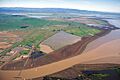
The mouth of the Petaluma River on San Pablo Bay. View is to the northeast.
-
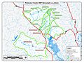
Petaluma River Watershed 2007 Steelhead Trout Biosurvey


