Sonoma Mountain facts for kids
Quick facts for kids Sonoma Mountain |
|
|---|---|
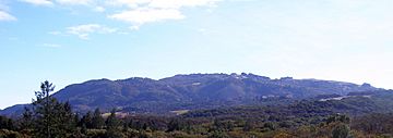
Sonoma Mountain from Annadel State Park.
|
|
| Highest point | |
| Elevation | 2,463 ft (751 m) NAVD 88 |
| Geography | |
| Location | Sonoma County, California, U.S. |
| Parent range | Sonoma Mountains |
| Topo map | USGS Glen Ellen, CA (map image) |
| Climbing | |
| Easiest route | Trail |
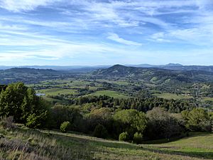
Sonoma Mountain is a large landform in the Sonoma Mountains of southern Sonoma County, California. It stands tall at about 2,463 ft (751 m). From its top, you can see wide views of the Pacific Ocean to the west. To the east, you can see the beautiful Sonoma Valley.
The eastern and northern sides of the mountain are cooler and more protected from the hot afternoon sun. Because of this, they have many forests with oak trees. The soil here is also rich and drains water well. The western and southern sides are drier and warmer. They have fewer dense forests and more chaparral (shrubs), grassland, and oak savannah areas.
Contents
How Sonoma Mountain Was Formed: Geology
About twelve million years ago, the area where Sonoma Mountain now stands was actually under the Pacific Ocean. During a time called the Miocene era, big changes happened. The Earth's plates moved, and hot magma was close to the surface. This caused a huge uplift, pushing the land upwards. This is how the volcanic Sonoma Mountains and the Mayacamas Mountains to the east were formed.
You can still see signs of this ancient activity today. There are hot springs nearby, like Mortons Hot Springs and Agua Caliente Hot Springs. The active Rodgers Creek Fault also shows that the Earth's plates are still moving here. Water from the eastern slopes of Sonoma Mountain flows into Sonoma Creek. Water from the northern parts goes into Matanzas Creek. The southwestern parts drain into the Petaluma River watershed.
The eastern slopes, which are easy to reach, mostly have Goulding clay loam soils. These soils are found on slopes that are 15 to 30 percent steep. They support thick mixed oak forests with many California laurel and bigleaf maple trees. Higher up the eastern slopes, the soil is still Goulding clay loam but on steeper 30 to 50 percent slopes. These areas also have dense forests, but with more Pacific madrone and California live oak trees. The soil is usually only a few feet deep before hitting bedrock. Even thin soils can support rich plant growth because they have many nutrients and the climate is mild.
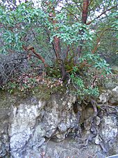
The very top of Sonoma Mountain and its higher northern slope have Goulding cobbly loam soil. These areas have slopes of five to fifteen percent and can have up to 20 percent cobblestones near the surface. You can often see outcrops of basalt rock here. This shows that Sonoma Mountain was formed by volcanic activity. The upper western parts of Sonoma Mountain have some Raynor clay soil. This type of soil is usually about four to five feet deep before reaching bedrock. Lower down on the western side, near the Lichau Creek area, there is a lot of Goulding clay loam on slopes of about 15 to 25 percent.
Plants and Animals: Ecology
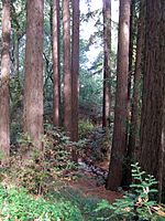
The green forests on the eastern side of Sonoma Mountain get water from Graham Creek and its smaller streams all year round. The most common plant community on the eastern slopes is the oak woodland. The top layer of trees, called the canopy, includes California live oak, Garry oak, California black oak, Pacific madrone, Bigleaf maple, and California laurel. In some of the steeper, cooler areas near streams (called riparian zones), you can find small groups of coast redwood trees.
Underneath these oak trees, the main plants are toyon, blackberry, western poison-oak, and sometimes coyote brush in drier spots. Many animals live here, including California mule deer, gray squirrel, raccoon, skunk, and opossum. Sometimes, you might even see a bobcat or a mountain lion. There are also many different birds, like the scrub jay, Steller's jay, acorn woodpecker, and junco.
Because the soil is rich and the weather is mild, there are large vineyards on the northeast side of the mountain. These vineyards are located up to 1,700 feet (518 m) high. They are like patches in the mostly oak forest. The grapes grown here are used to make special wines, some of which are sold as premium Sonoma Valley wines.
Jack London State Historic Park
Jack London State Historic Park is located on the eastern slope of Sonoma Mountain, near Glen Ellen, California. This California State Park is named after the famous author Jack London. His home, called Wolf House, was here. It was a large stone building that was destroyed by fire. Its beautiful ruins are now protected inside the state park.
Sonoma Mountain was very important to Jack London and his writing. In 1910, he bought this 1,000-acre (4 km2) property, which he called the Beauty Ranch, for $26,000. He once wrote that "Next to my wife, the ranch is the dearest thing in the world to me." He wanted the ranch to be a successful business. Writing, which was always a way for London to earn money, became even more important for this goal. He said, "I write for no other purpose than to add to the beauty that now belongs to me. I write a book for no other reason than to add three or four hundred acres to my magnificent estate." The park's sloped land has a trail that leads towards the top of Sonoma Mountain. However, the very peak of the mountain is not part of the state park.
North Sonoma Mountain Regional Park
The North Sonoma Mountain Regional Park and Open Space Preserve covers 820 acres (330 ha) of Sonoma Mountain. It is right next to Jack London State Historic Park. This land was bought for public use between 2003 and 2015.
The park opened in February 2015. It has 20 miles (32 km) of dirt trails for people who like to hike, run, or ride horses. The trails connect with the Hayfields Trail in Jack London park. Together, they form an 8-mile (13 km) part of the Bay Area Ridge Trail. From the Ridge Trail at 2,000-foot (610 m) high, you can see a wide view of the Sonoma Valley and the Santa Rosa plain. Some viewpoints have picnic tables.
Some trails are closed to mountain bikes, and dogs are not allowed in the park. You can get into the park through the old Jacobs Ranch at 5297 Sonoma Mountain Road. This is about 3 miles (4.8 km) from Bennett Valley Road. The park is open from 7:00 AM until sunset. If you have a Regional Parks membership, you don't have to pay the $7 parking fee. There is a bathroom at the parking lot, but no drinking water. There is also a trail that wheelchairs can use. It goes from the parking lot to picnic tables in a shady area by Matanzas Creek.
Fairfield Osborn Preserve
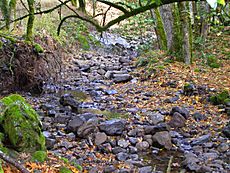
The Fairfield Osborn Preserve is a 460-acre (1.86 km2) nature reserve. It is located on the northwest side of Sonoma Mountain in Sonoma County, California. The preserve has several types of plant communities. The most common type is oak woodland. Other areas include chaparral, native clump grassland, marsh, coastal scrub, and areas near streams (riparian zones).
Many different animals live here. These include black-tailed deer, coyote, bobcat, and mountain lion. There are also many birds, amphibians, reptiles, and insects. The plants are very diverse, with many native trees, shrubs, grasses, lichens, and mosses. Copeland Creek and its smaller streams flow through the preserve. They wind down steep ravines and eventually flow into the Laguna de Santa Rosa.
This land was originally part of a Spanish Land Grant. Now, Sonoma State University owns and manages it. They use it for research and to teach the public about nature. There is a simple natural trail system that goes through the property. It gives access to creek canyons, ridges, and marshy areas. The preserve is located at elevations from 1,600 to 1,900 feet (488–579 m) above sea level. You can see many basalt rocks here, which show the volcanic prehistory of Sonoma Mountain.
Growing Grapes: Viticulture
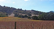
Sonoma Mountain gives its name to the Sonoma Mountain AVA. This is a special area recognized by the government for growing grapes.
The peak of Sonoma Mountain also helps define part of the boundary for the Sonoma Coast AVA. This is another grape-growing region. Wines made from grapes grown on the western and southern slopes of Sonoma Mountain can be called Sonoma Coast wines. However, wines made from grapes grown on the eastern and northern slopes do not qualify for that name.
Antenna
The TV broadcast antenna for KRCB is located at the very top of Sonoma Mountain, just north of the summit.
 | Jessica Watkins |
 | Robert Henry Lawrence Jr. |
 | Mae Jemison |
 | Sian Proctor |
 | Guion Bluford |


