Fairfield Osborn Preserve facts for kids
The Fairfield Osborn Preserve is a special natural area. It covers 450 acres (about 1.8 square kilometers) on the side of Sonoma Mountain in Sonoma County, California. This preserve is like a home for many different plants and animals. It has eight main types of plant areas, with oak woodlands being the most common.
You can also find chaparral (a type of scrubland), Douglas fir forests, and areas with native Bunch grass. There are even freshwater marshes, vernal pools (ponds that fill with water in spring), and riparian woodlands (forests along streams). The plants here are very diverse, including many native trees, shrubs, wildflowers, grasses, lichens, and mosses.
Many animals live here too! You might see black-tailed deer, coyotes, bobcats, and sometimes even a mountain lion. There are also lots of birds (some that travel long distances), amphibians like frogs, reptiles like snakes, and many kinds of insects.
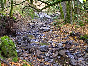
Copeland Creek and its smaller streams flow through the preserve. They wind down steep ravines and eventually reach the Laguna de Santa Rosa. The land was once part of a Spanish Land Grant. Later, it became private property. Now, Sonoma State University owns and manages it. They use it for research and teaching.
There are natural trails that let you explore the preserve. You can see creek canyons, ridges, and marshy spots. The preserve is high up, from 1,350 to 2,300 feet (411 to 701 meters) above sea level. You'll see many basalt rocks, which show that this area was once volcanic. The weather here is mild, with most rain in winter. The nearby Pacific Ocean keeps temperatures moderate and sometimes brings fog in the mornings.
Contents
Soils: The Ground Beneath Your Feet
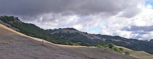
The steep slopes around Copeland Creek mostly have Goulding clay loam soils. This soil is usually only about 16 to 20 inches (41 to 51 centimeters) deep. These areas have slopes from 15 to 45 percent. They support thick mixed oak forests, with many California laurel and Bigleaf maple trees.
On the higher, drier slopes, there are terraces of Raynor clay. These areas hold more moisture and are found near the Turtle Pond and Cattail Marsh. Both soil types were used for grazing animals like sheep and cattle in the late 1800s. People also cut down trees for firewood and took it down the mountain.
Hydrology: How Water Flows
Copeland Creek and its smaller streams collect water from the preserve. All these streams start on Sonoma Mountain. They eventually flow into the Laguna de Santa Rosa, which then flows into the Russian River. Copeland Creek is the southernmost stream in the Russian River area. Streams south of Copeland Creek, like Lichau Creek, flow into the San Francisco Bay.
The amount of rainfall in the Copeland Creek area is moderate for California. Even during heavy rain, the most water that falls in one hour is usually less than average (about 1.90 inches or 48 millimeters). Because many parts of Copeland Creek are very steep (over 50 percent slope), the water flows very fast in winter. The soils can erode easily, but the many basalt rocks in Copeland Creek help protect it. This means the stream water usually stays clear and doesn't have much sediment.
Ecology: Plants and Animals of the Preserve
The main plant areas in the preserve include the large California oak woodland savanna. You'll also find chaparral, marshes, native Bunch grass, Douglas-fir forests, and riparian woodlands. In the oak woodlands, the main trees are Coast live oak, Oregon oak, California black oak, Canyon live oak, and California bay laurel.
Underneath the trees, you'll see plants like toyon, coffeeberry, and poison oak. In higher, more open areas that meet the chaparral, you'll find coyote brush. Sometimes, these woodlands open up into small grasslands. These grasslands are full of different grasses and yearly wildflowers. For example, you can see yellow hayfield tarweed blooming in late autumn.
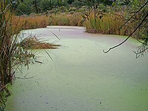
The freshwater marsh was created by a huge land movement along the Rodgers Creek Fault. The two ponds in the preserve were made by people in the early 1900s. These wet areas are very important homes for many animals. This includes birds like sora and Virginia rails, western pond turtles, and the endangered Red-legged Frog. Natural springs feed these spots, helping the plants grow strong and stable. Turtle Pond has a layer of duckweed on its surface, which many animals eat.
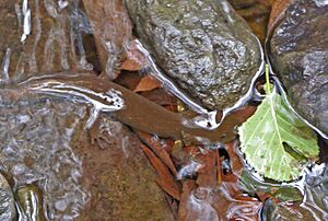
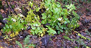
The areas along Copeland Creek (riparian zones) have many California bay laurel trees. They also provide a home for many amphibians, newts, and other animals. The Pacific giant salamander, one of the largest salamanders, hunts for prey in Copeland Creek. Other amphibians you might see are the Pacific treefrog, the Rough-skinned newt, and the California slender salamander. Some plants that like the deep shade of the riparian zone include snowberry and the rare California ginseng.
History: A Look Back in Time
Archeological studies show that the area was used by Pomo, Miwok, and Wappo people. They were hunting and gathering here seasonally and traveled to find food and trade. The first written records from the 1860s show the property was part of a Spanish Land Grant.
In the late 1800s, farming increased, especially grazing animals. By the 1890s, the land was a sheep and cattle ranch owned by the Duerson family. In the 1950s, William Matson Roth bought the land as a summer retreat for his family. William and his wife Joan gave the land to The Nature Conservancy in 1972. The preserve was named after Joan's father, Henry Fairfield Osborn, Jr, who was a conservationist and writer.
In 1977, The Nature Conservancy leased the preserve to Sonoma State University (SSU). SSU uses it for environmental education field trips, teaching up to 4,000 schoolchildren each year. In 1997, SSU officially took ownership. They continue to use it for research and education. In 2004, William and Joan Roth gave another 190 acres (76 hectares) to the preserve. Both parts of the preserve are managed to protect their natural state. In 2009, SSU created a special group to manage both the Fairfield Osborn and the Galbreath Wildlands Preserves.
Visiting the Preserve
The preserve is open for research and educational programs. The public can visit only with a guided tour. Many tour guides are students from Sonoma State University, but some are also from the local community. Tours are usually offered on Saturdays at 10 AM in the fall and spring.
Besides the guided nature hikes, there are also special workshops. These are taught by professors from Sonoma State University and other scientists. They cover topics like geology (the study of rocks), mycology (the study of fungi), and amphibians.
The preserve is located between Petaluma and Santa Rosa, California. You can get there from Petaluma Hill Road, then Roberts Road, and Lichau Road. Along Roberts Road, you can see where work was done in the late 1990s to restore lower Copeland Creek. This work helped control erosion, planted native trees along the stream, and kept cattle away. The paved road also has a "gravity hill" – an optical illusion that makes it feel like you're going uphill when you're actually going downhill!
 | Stephanie Wilson |
 | Charles Bolden |
 | Ronald McNair |
 | Frederick D. Gregory |


