
Laguna de Santa Rosa facts for kids
Quick facts for kids Laguna de Santa Rosa |
|
|---|---|

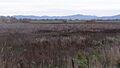
Looking northeast across the Laguna de Santa Rosa with the Mayacamas Mountains in the background
|
|

Location of the mouth of Laguna de Santa Rosa in California
|
|
| Country | United States |
| State | California |
| Region | Sonoma County |
| Cities | Santa Rosa, Sebastopol, Cotati |
| Physical characteristics | |
| Main source | west of Cotati, California 260 ft (79 m) 38°19′4″N 122°43′21″W / 38.31778°N 122.72250°W |
| River mouth | Mark West Creek east of Forestville, California 46 ft (14 m) 38°28′12″N 122°50′27″W / 38.47000°N 122.84083°W |
| Length | 22 mi (35 km) |
| Basin features | |
| Basin size | 254 sq mi (660 km2) |
| Tributaries |
|
| Protection status | |
| Official name: Laguna de Santa Rosa Wetland Complex | |
| Designated: | 16 April 2010 |
| Reference #: | 1930 |
The Laguna de Santa Rosa is a special natural area in Sonoma County, California. It's a long, winding system of wetlands, about 22 miles (35 km) long. This area collects water from a large watershed, which is like a big bowl that gathers all the rain and streams from 254 square miles (658 sq km) of land.
The Laguna is very important for the environment. It helps control floods and is home to many different kinds of plants and animals. Because of past pollution, it's not safe to eat fish caught here. This is due to high levels of mercury and other chemicals.
Contents
Discover the Laguna de Santa Rosa
The Laguna de Santa Rosa is a major tributary, or smaller stream, that flows into Mark West Creek. Its main streams start in the southern parts of the Sonoma Mountains and Mayacamas Mountains. During heavy winter rains, the Laguna becomes a large floodplain, holding a lot of stormwater. This helps prevent flooding in nearby towns.
Beyond just managing water, the Laguna is a treasure for wildlife. It has the most diverse plant and animal life in Sonoma County. Many rare and endangered species live here. This includes special fish like salmon and three types of endangered plants found only in this area.
For a long time, from about 1870 to 1990, the Laguna's water quality got worse. This was because of more cities and farms growing in the area. But since the 1990s, people have been working to make it healthier again. Even with past problems, the Laguna de Santa Rosa is the second-largest freshwater wetland in coastal Northern California.
It's a home or resting place for over 200 types of birds. You can also find bald eagles, golden eagles, osprey, mountain lions, river otters, coyotes, bobcats, and gray foxes here.
Protecting and Restoring the Laguna
Even though human activities have greatly affected the Laguna over the last 100 years, many people are now working to protect and restore it. They want to help its natural functions, like providing habitat for animals and controlling floods. They also want to create places for outdoor recreation, education, and research.
The Laguna de Santa Rosa Foundation is a group that started in 1989. Since 2002, they have been leading efforts to protect and restore the Laguna. They also help people learn about and enjoy this special place.
Where the Laguna Flows
The Laguna de Santa Rosa begins in the hills east of U.S. Route 101 near Cotati, California. It flows west, going under U.S. Route 101 and into Cotati. It then turns northwest, forming part of the border between Cotati and Rohnert Park.
As it continues northwest, other streams join it, like Copeland Creek, Washoe Creek, Hinebaugh Creek, and Five Creek. East of Sebastopol, it goes under California State Route 12. Then it turns north. Near Guerneville Road, the Santa Rosa Flood Control Channel adds water from Santa Rosa Creek. Finally, the Laguna flows north and empties into Mark West Creek near Forestville.
History of the Laguna and Its People
Long ago, archaeological findings show that three groups of Pomo people lived around the Laguna de Santa Rosa. These groups were the Konhomtara, the Kataictemi, and the Bitakomtara. They each had their own land and language.
- The Konhomtara lived near present-day Sebastopol.
- The Kataictemi lived along the Russian River.
- The Bitakomtara lived in the Santa Rosa area and controlled the eastern Laguna lands.
These groups had strict rules about who could use the land. If one group wanted to fish in another group's area, they had to ask for permission. Over 80 ancient sites of the Pomo people have been found within the Laguna's historic marshlands.
The Laguna's rich wetlands were very important to the Pomo people. They provided plenty of fish, birds, and tule reeds. Tule reeds were used to build homes and canoes.
In 1833, the first land grants were given out by Mexico in the Laguna area. By 1870, the railroad arrived, and more land was used for farming. This caused changes to the Laguna. By the 1960s, much of the eastern plain was developed. The number of fish, like salmon, had dropped greatly. By 1989, over 92 percent of the Laguna's natural riverside habitat was gone, and its water quality was very poor.
Historically, cities nearby sent their untreated or partly treated sewage into the Laguna. Later, the city of Santa Rosa worked to improve its sewage treatment. They now treat the wastewater much better and use it to water hay farms. This has helped the Laguna's water quality.
In 1989, the Laguna de Santa Rosa Foundation was created. This group works to protect and restore this natural area. They have created education programs and worked on many projects to improve the Laguna's water and environment. They also published a plan in 2006 called Enhancing and Caring for the Laguna. This plan guides efforts to improve the Laguna's environment and create trails for people to enjoy.
Understanding the Laguna's Geology

Millions of years ago, this whole area was under the Pacific Ocean. About 12 million years ago, mountains like the Mayacamas and Sonoma Mountains formed. Over time, streams carved out these mountains, creating the rich soils of the Santa Rosa Plain and the Laguna de Santa Rosa.
The soils in the Laguna area are mostly a type of clay called Clear Lake clay. This soil is found in areas where water doesn't drain well.
Water Flow and Quality

The Laguna de Santa Rosa is a main branch of Mark West Creek. Many other streams flow into the Laguna, including Santa Rosa Creek, Copeland Creek, Hinebaugh Creek, Five Creek, Washoe Creek, and Blucher Creek. In the dry summer, the Laguna is a winding stream. But in the winter, during storms, it becomes a huge floodplain that looks like a series of lakes.
There are also many vernal pools on the floodplain. These are temporary pools that fill with water in the wet season and dry up later. They are home to many rare and endangered species.
The Laguna de Santa Rosa has water quality issues. It is listed as "Impaired" under the federal Clean Water Act for several reasons. These include too much sediment, nitrogen, phosphorus, high temperature, mercury, and low dissolved oxygen. It has the most "Impaired" listings of any water body on the North Coast of California.
Laguna's Amazing Ecology
The Laguna de Santa Rosa is important for recreation, farming, and industry. But most importantly, it's a vital wildlife habitat. It has many different types of habitats, including:
- Riverside forests and floodplains
- Seasonal wetlands and vernal pools
- Upland valley oak savannas
- Freshwater tule marshes
Many rare and endangered species live in the Laguna. These include the California tiger salamander (Ambystoma californiense), California freshwater shrimp (Syncaris pacifica), and Sebastopol meadowfoam (Limnanthes vinculans).
The Laguna is also part of the Pacific Flyway, a major route for migrating birds. Over 200 types of birds live, feed, or rest here during their migrations. Some of these birds are the Ridgway's rail, Canada goose (Branta canadensis), turkey vulture (Cathartus aura), black-necked stilt (Himantopus mexicanus), burrowing owl (Athene cunicularia), great egret (Casmerodius albus), great blue heron (Ardea herodias), and American kestrel (Falco sparverius).
Fish like steelhead trout (Oncorhynchus mykiss) and coho salmon (Oncorhynchus kisutch), which are threatened or endangered, travel through the Laguna to lay their eggs in its smaller streams.
Who Manages the Laguna?
Much of the Laguna's important habitat is privately owned. Many government groups also help manage its water, land, and natural resources.
- The United States Army Corps of Engineers studies water quality.
- The National Marine Fisheries Service helps protect endangered fish.
- The California Department of Fish and Game helps protect species.
- The North Coast Regional Water Quality Control Board controls water quality.
- The Sonoma County Water Agency manages flood control.
- The City of Santa Rosa manages its wastewater treatment plant in the Laguna area.
- The City of Sebastopol owns land in the Laguna that it manages as public parkland.
In the private sector, the Laguna de Santa Rosa Foundation is very active. They plan projects, educate the public, restore habitats, and do research.
On February 2, 2011, the Ramsar Convention on Wetlands recognized the Laguna as a wetland of international importance. This means it's a very special place for wetlands around the world. This recognition covers about 3,894 acres (1,576 hectares) of the Laguna.
Bridges Over the Laguna
Many bridges cross the Laguna, especially along the busy U.S. Route 101 corridor. Here are some of them:
- At Old Redwood Highway, a concrete culvert built in 1956.
- At U.S. Route 101 northbound, a concrete culvert built in 1956.
- At U.S. Route 101 southbound, a concrete bridge built in 1919 and rebuilt in 1994.
- At Redwood Drive, a concrete culvert built in 1956 and rebuilt in 2002.
- At Llano Road, a concrete slab bridge built in 1962.
- At Todd Road, a concrete slab bridge built in 1973.
- At Stony Point Road, a concrete slab bridge built in 1960 and rebuilt in 1994.
- At State Route 12, a concrete bridge built in 1921, rebuilt in 1949 and again in 2017.
- At Occidental Road, a concrete slab bridge built in 1990.
- At Guerneville Road, a concrete bridge built in 1957.
Images for kids
-
Looking east across the Laguna de Santa Rosa floodplain, with the Mayacamas Mountains in the background
-
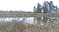
Tule-edged pond for water polishing treatment of effluent from City of Santa Rosa sewage treatment, Laguna de Santa Rosa
