
Washoe Creek facts for kids
Quick facts for kids Washoe Creek |
|
|---|---|

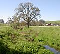
Channelized lower reaches of Washoe Creek, in spring.
|
|

Location of the mouth of Washoe Creek in California
|
|
| Country | United States |
| State | California |
| Region | Sonoma County |
| City | Cotati |
| Physical characteristics | |
| Main source | 3 mi (5 km) southwest of Cotati, California 400 ft (120 m) 38°18′25″N 122°44′58″W / 38.30694°N 122.74944°W |
| River mouth | Laguna de Santa Rosa west of Rohnert Park, California 85 ft (26 m) 38°21′0″N 122°43′59″W / 38.35000°N 122.73306°W |
| Length | 2 mi (3.2 km) |
| Basin features | |
| Tributaries |
|
Washoe Creek is a small stream in Sonoma County, California. It flows all year round, even when it doesn't rain much. The creek is about 2 miles (3.2 kilometers) long. It eventually flows into the Laguna de Santa Rosa, which is a large wetland area.
The creek starts in the low hills called Meacham Hills. These hills are southwest of the city of Cotati. From there, Washoe Creek flows northeast. It goes under roads like Roblar Road and Stony Point Road. Then, it turns north and runs next to Stony Point Road. It also crosses under West Sierra Avenue and Madrone Avenue.
After crossing Gravenstein Highway (also known as State Route 116), the creek flows into a special channel made by people. Another small creek, Gossage Creek, joins Washoe Creek from the west. Soon after, Washoe Creek reaches its end. It joins the Laguna de Santa Rosa, just west of Rohnert Park.
Nature Around the Creek
The land around Washoe Creek used to be covered in special plants. These plants grew near the water, forming a type of forest called a riparian woodland. Away from the creek, there were open areas with Valley Oak trees and wide grasslands.
Over time, people have changed these natural areas. Now, much of the land is used for things like grazing animals, farming, and building cities. This has changed the natural habitats for plants and animals.
Scientists have found that Washoe Creek has higher levels of certain chemicals, like nitrates, in its water. These levels are higher than in other streams that flow into the Laguna de Santa Rosa. People are thinking about starting a restoration project. This project would help bring the lower part of the creek back to a more natural and healthy state.
History of Washoe Creek
People have lived near Washoe Creek for a very long time. The Coast Miwok people settled here at least 4,000 years ago (around 2000 BC). They built small villages along Washoe Creek and other nearby streams. These early people gathered food from the creek and the surrounding land to survive.
In 1833, the entire area around what is now Cotati became part of a Mexican land grant. This was a large piece of land given by the Mexican government.
One of the first American settlers in the area was Robert Ayres. In 1859, he built a famous building called Washoe House. This house was built near where the creek begins.
Stony Point Quarry

In the early 1900s, there was a rock quarry on Petersen Road. This quarry was later closed. A new quarry then opened on Stony Point Road. Washoe Creek flows just across Stony Point Road from where this quarry is today. Quarries are places where rocks are dug out of the ground.
Images for kids
-
Channelized lower reaches of Washoe Creek, in spring.
