Forestville, California facts for kids
Quick facts for kids
Forestville
|
|
|---|---|

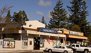
Downtown Forestville in 2007
|
|

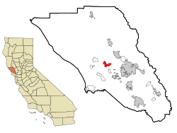
Location in Sonoma County and the state of California
|
|
| Country | |
| State | |
| County | Sonoma |
| Area | |
| • Total | 5.257 sq mi (13.615 km2) |
| • Land | 5.257 sq mi (13.615 km2) |
| • Water | 0 sq mi (0 km2) 0% |
| Elevation | 171 ft (52 m) |
| Population
(2010)
|
|
| • Total | 3,293 |
| • Density | 626.40/sq mi (241.87/km2) |
| Time zone | UTC-8 (PST) |
| • Summer (DST) | UTC-7 (PDT) |
| ZIP code |
95436
|
| Area code(s) | 707 |
| FIPS code | 06-24960 |
| GNIS feature ID | 1658564 |
Forestville is a small community in Sonoma County, California, United States. It's called a census-designated place (CDP) because it's a special area used for gathering census data.
The town was first settled in the late 1860s. It was originally spelled "Forrestville" after one of its founders, but the spelling changed to "Forestville" a long time ago. In 2010, about 3,293 people lived there. This was almost 1,000 more people than in 2000! By the early 1900s, Forestville became known as a place that attracted writers and artists.
Contents
History and Community Life
Forestville has an unofficial saying: "Forestville, The Good Life." You can even see this phrase on license plate holders sold at the local hardware store. The main road through town is called Front Street. It's about three blocks long and is now part of Highway 116.
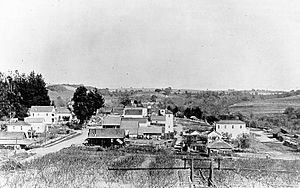
The "downtown" area of Forestville was first built in the 1870s and 1880s. However, a big fire destroyed many of the old buildings. So, most of the buildings you see today were built in the early 1900s. A professor from Sonoma State University, Jonah Raskin, said that around 1900, Forestville was a popular spot for artists and writers.
Today, Forestville has many useful businesses. You can find a gas station, a bar, a hardware store, a grocery store, and two convenience stores. There's also a pharmacy, several churches, different restaurants, and a post office. The town has a fire station run by volunteers and a Youth Park, which is also run by volunteers. You can also find three ATMs for your banking needs.
Every June, the town holds the annual Forestville Youth Park Parade. This event helps raise money for the Youth Park. It's a fun two-day event with music, bingo, and carnival rides. Local sellers and non-profit groups set up booths to sell food and handmade crafts. Many cozy bed and breakfast inns and wineries have also been built near the Russian River and to the east of town.
Geography and Natural Surroundings
Forestville is located in the middle of Sonoma County, about 60 miles (97 km) north of San Francisco. The area covers about 5.3 square miles (13.7 km²), and all of it is land. There are no large bodies of water within the town limits.
Close to Forestville, two important waterways meet: the Laguna de Santa Rosa and Mark West Creek flow into the Russian River. South of Forestville, you can find some special and rare plants, like the endangered Pitkin Marsh lily and White sedge.
To the north of town, you'll find the Russian River, Steelhead Beach Park, and Mount Jackson. To the west, there are beautiful Redwood forests. To the east and south, the landscape changes to rolling hills. These hills are covered with wine grape vineyards and apple orchards.
Population and People
| Historical population | |||
|---|---|---|---|
| Census | Pop. | %± | |
| 1880 | 84 | — | |
| 1990 | 2,443 | — | |
| 2000 | 2,370 | −3.0% | |
| 2010 | 3,293 | 38.9% | |
| 2020 | 3,264 | −0.9% | |
| 2021 (est.) | 3,768 | 14.4% | |
| U.S Census 1880, 1990, 2000-2020 | |||
The population of Forestville has grown over the years. In 2010, there were 3,293 people living in the area. Most of the people living in Forestville are White. In 2010, about 88.5% of the population was White. About 12.3% of the people were of Hispanic or Latino background. Other groups, like African American, Native American, and Asian people, also live in Forestville.
The average age of people in Forestville in 2010 was about 47.5 years old. This means many adults and older people live in the community.
Forestville tends to support the Democratic Party in presidential elections. For example, in the 2020 election, most voters in Forestville supported the Democratic candidate.
School System
Forestville has two schools: Forestville Elementary School and El Molino High School. El Molino High School used to serve students from 9th to 12th grade in the Russian River area. In the 2017–18 school year, about 595 students attended the high school.
However, the El Molino High School campus closed permanently in the fall of 2021. All its students moved to Analy High School in Sebastopol. The West Sonoma County Union High School District office and Laguna High School, which is a continuation school, are now located at the old El Molino campus.
Transportation and Roads
The main road in Forestville is California State Route 116. People in the area call it the Pocket Canyon Highway, Front Street, or the Gravenstein Highway. North of the downtown area is River Road. This road connects the northern part of Forestville to the coastal town of Jenner in the west. It also provides access to U.S. Route 101 and the Sonoma County Airport to the east. The Sonoma County Airport is the closest airport with commercial flights to Forestville.
You can also get around Forestville using public transportation. Sonoma County Transit bus route 20 serves the area.
Notable People
- James Walker Benét: A reporter for the San Francisco Chronicle and KQED. He was also a veteran of the Abraham Lincoln Brigade during the Spanish Civil War.
- Rosemary Gladstar: She started an herbal school named after her.
- Ben McKee: The bassist for the popular band Imagine Dragons.
- Catherine Yronwode: An editor of comic books and non-fiction trading cards, and also an author and graphics designer.
See also
 In Spanish: Forestville (California) para niños
 | Toni Morrison |
 | Barack Obama |
 | Martin Luther King Jr. |
 | Ralph Bunche |


