Sonoma Mountains facts for kids
Quick facts for kids Sonoma Mountains |
|
|---|---|

Sonoma Mountain
|
|
| Highest point | |
| Peak | Sonoma Mountain |
| Elevation | 2,287 ft (697 m) |
| Dimensions | |
| Length | 14 mi (23 km) northwest-southeast |
| Geography | |
| Country | United States |
| State | California |
| Region | Sonoma County |
| Range coordinates | 38°17′59.693″N 122°33′3.939″W / 38.29991472°N 122.55109417°W |
| Parent range | California Coast Ranges |
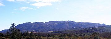
The Sonoma Mountains are a beautiful mountain range in Sonoma County, Northern California. These mountains stretch from the northwest to the southeast. They are part of a larger group of mountains called the California Coast Ranges.
Contents
Exploring the Sonoma Mountains: What You'll Find
The Sonoma Mountains are about 14 miles (22.5 kilometers) long. They create a natural border between different watersheds. A watershed is an area of land where all the water drains into a specific river or body of water. Here, they separate the area that drains into Sonoma Creek from areas that drain into the Petaluma River and Tolay Creek.
The tallest point in this range is Sonoma Mountain. It stands at 2,287 feet (697 meters) high.
Parks and Preserves in the Mountains
Several cool parks and nature areas are located right on Sonoma Mountain. These include Jack London State Historic Park, Crane Creek Regional Park, and the Fairfield Osborn Preserve. These places are great for hiking and exploring nature.
Special Plants and Animals
The Sonoma Mountains are home to many unique plants and animals. Some of these species are considered threatened or endangered species. This means they are at risk of disappearing forever. One example is the Fragrant fritillary (Fritillaria liliacea). This is a special type of flower that grows here.
Waterways of the Sonoma Mountains: Where Rivers Begin
Many creeks and streams start high up in the Sonoma Mountains. These waterways flow in different directions, eventually reaching the ocean or large bays.
Creeks Flowing North and West
From the northwestern parts of the mountains, creeks like Copeland Creek and Hinebaugh Creek begin their journey. They flow into the Laguna de Santa Rosa. Eventually, their waters reach the Pacific Ocean near Jenner, California. Other creeks, such as Matanzas Creek and Spring Creek, flow north into Santa Rosa Creek. This creek is also a part of the Laguna de Santa Rosa system.
Creeks Flowing East
On the eastern side of the Sonoma Mountains, several creeks start and flow towards Sonoma Creek. These include Yulupa Creek, Carriger Creek, Graham Creek, Felder Creek, and Rogers Creek. These creeks eventually join Sonoma Creek, which then flows into San Pablo Bay south of Sonoma, California.
Creeks Flowing Southwest
The southwestern slopes of the mountains also have creeks that drain into San Pablo Bay. These include Tolay Creek and other streams that feed into the Petaluma River. Some of these Petaluma River tributaries are Lichau Creek, Lynch Creek, and Adobe Creek.
 | Lonnie Johnson |
 | Granville Woods |
 | Lewis Howard Latimer |
 | James West |


