
Spring Creek (Sonoma County, California) facts for kids
Quick facts for kids Spring Creek |
|
|---|---|

Spring Creek streambed high in headwaters area
|
|

Location of the mouth of Spring Creek in California
|
|
| Country | United States |
| State | California |
| Region | Sonoma County |
| City | Santa Rosa, California |
| Physical characteristics | |
| Main source | Bennett Mountain Annadel State Park 1,220 ft (370 m) 38°25′18″N 122°36′46″W / 38.42167°N 122.61278°W |
| River mouth | Matanzas Creek west end of Doyle Park in Santa Rosa, California 164 ft (50 m) 38°26′21″N 122°42′1″W / 38.43917°N 122.70028°W |
Spring Creek is a small stream located in Sonoma County, California. It is about 6 miles (9.7 km) long. This creek starts high up in the Sonoma Mountains.
It begins inside Annadel State Park. The creek then flows down the western side of Taylor Mountain. Spring Creek eventually joins Matanzas Creek at Doyle Community Park. This happens just below the Matanzas Creek Reservoir.
Journey to the Ocean
The water from Spring Creek has a long journey. It travels through several other waterways. First, it flows into Matanzas Creek. After that, it joins Santa Rosa Creek.
Next, the water enters the Laguna de Santa Rosa. From there, it moves into Mark West Creek. Finally, all these waters flow into the Russian River. The Russian River then carries the water all the way to the Pacific Ocean. This happens near Jenner, California.
Where Spring Creek Flows
Spring Creek starts in a beautiful natural area. This area is known as the Sonoma Mountains. The creek's source is on Bennett Mountain. This mountain is part of Annadel State Park.
The creek flows through different landscapes. It passes through parts of Santa Rosa, California. Its journey ends when it meets Matanzas Creek. This meeting point is in Doyle Park.
Images for kids
-
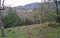
This picture shows the area where Spring Creek begins. This is called the headwaters.
-
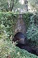
Here is a bridge over Spring Creek. It is located in Doyle Community Park.


