San Mateo–Hayward Bridge facts for kids
Quick facts for kids San Mateo–Hayward Bridge |
|
|---|---|
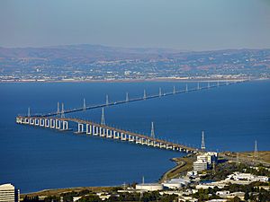
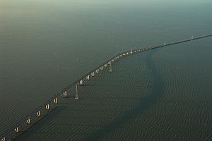
Aerial view of the San Mateo–Hayward Bridge, with Foster City in the foreground
|
|
| Coordinates | 37°36′07″N 122°12′17″W / 37.6019°N 122.2047°W |
| Carries | 6 lanes of |
| Crosses | San Francisco Bay |
| Locale | Foster City and Hayward, California, United States |
| Other name(s) | San Mateo Bridge |
| Owner | State of California |
| Maintained by | Caltrans and BATA |
| ID number | 35 0054 |
| Characteristics | |
| Design |
|
| Total length |
|
| Width | 41 m (135 ft) roadway approach |
| Longest span | 757.2 ft (230.8 m) |
| Number of spans |
|
| Clearance above | 134.5 ft (41.0 m) |
| Clearance below | 134.5 ft (41.0 m) |
| History | |
| Designer | Caltrans, Bay Toll Crossings Division |
| Constructed by |
|
| Fabrication by | Murphy Pacific Corporation, Emeryville |
| Construction cost | $70,000,000 (equivalent to $440 million in 2021 ) |
| Opened |
|
| Statistics | |
| Daily traffic | 93,000 |
| Toll |
|
The San Mateo–Hayward Bridge, often called the San Mateo Bridge, is a very long bridge in California. It crosses the San Francisco Bay, connecting the San Francisco Peninsula with the East Bay. One end is in Foster City, and the other is in Hayward.
This bridge is the longest fixed bridge in California. It is also one of the longest bridges in the world! The state of California owns it, and California Department of Transportation (Caltrans) helps keep it in good shape. The Bay Area Toll Authority (BATA) also helps manage it.
The bridge is part of State Route 92. This road connects Interstate 880 in the East Bay to U.S. Route 101 on the peninsula. It's located between two other famous bridges: the San Francisco–Oakland Bay Bridge and the Dumbarton Bridge.
Contents
History of the San Mateo Bridge
The First Bridge (1929)
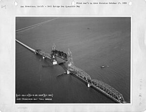
The first San Mateo Bridge opened on March 2, 1929. It was called the San Francisco Bay Toll Bridge. At the time, it was the longest bridge in the world! It was built by a private company.
Most of this old bridge was a flat causeway. But in the middle, it had a special section that could lift up. This "lift span" allowed tall ships to pass underneath. When the lift was down, cars could drive over. When it was up, ships could sail through.
A fun story about the old bridge involves the Stanford Axe. In 1930, Stanford students stole the Axe from Cal students. The Cal students thought the Stanford students would use the bridge to escape. A Stanford student working as the bridge operator heard about the chase. He raised the lift span to stop traffic, hoping to help his fellow Stanford students get away! However, the getaway car took a different route.
The state of California bought the bridge in 1951. By the 1950s, many more cars were using the bridge. The lift span had to open about six times a day for ships, which caused traffic delays.
The Modern Bridge (1967)
As more cars and ships used the bay, a new bridge was needed. Construction on the modern bridge began in 1961. It opened in 1967 and cost about $70 million. This new bridge was designed to be a fixed high-level bridge. This meant it would not have a lift span, so traffic would not stop for ships.
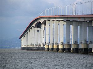
The new bridge won two awards in 1968 for its excellent design. It was designed by the Bay Toll Crossings Division of the California Department of Public Works. A special type of bridge deck, called an orthotropic deck, was used for the western highrise part. This design makes the bridge lighter and stronger.
A huge floating crane called the Marine Boss helped build the bridge. It could lift very heavy parts of the bridge into place. This crane was later sold and used for other big jobs. For example, it helped move the Concorde airplane and the Enterprise onto a museum ship. It also helped lift US Airways Flight 1549 from the Hudson River.
The entire bridge is about 7 miles (11.3 km) long. The western part is a highrise section, and the eastern part is a long, flat trestle. The highrise section goes over the main shipping channel. It is 750 feet (229 m) long and gives 135 feet (41 m) of clearance for ships.
The bridge's steel deck was paved with a special epoxy asphalt concrete. This material was very durable and lasted for almost 40 years before needing to be replaced.
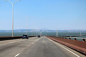
When it first opened, the highrise section had six lanes, but the eastern causeway only had four. This caused traffic jams. In 2002, the causeway was widened to six lanes, making traffic flow much better.
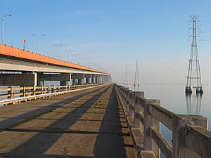
You might notice large power lines running next to the bridge. These lines were built in the 1950s by PG&E. They carry electricity to the peninsula and San Francisco.
Bridge Upgrades and Repairs
Earthquake Safety (1997–2000)
The bridge was closed briefly after the 1989 Loma Prieta earthquake to check for damage. From 1997 to 2000, the bridge underwent a major seismic retrofit. This project made the bridge much stronger and safer in case of another earthquake.
Adding More Lanes (2002–2003)
Before 2002, the bridge was known for its terrible evening traffic. To fix this, a new eastern trestle was built for westbound traffic. This project finished in 2002. The old trestle was then used only for eastbound traffic. This expansion increased the bridge to six lanes, matching the high-rise section. The speed limit was also raised to 65 miles per hour (105 km/h).
Beam Repair (2010–2015)
In 2010, a crack was found in a beam that was part of the earthquake safety upgrades. After a temporary fix, permanent repairs were made in 2012. This required closing the bridge for a weekend.
New Pavement (2015)
After almost 40 years, the bridge's original road surface needed to be replaced. In 2015, the highrise section was repaved with a new type of polyester concrete. This work required closing the bridge for two full weekends in May 2015. The new pavement is expected to last a very long time.
Werder Pier: A Piece of History
After the new bridge was built, most of the old 1929 bridge was taken down. However, the western part of the old bridge was saved. It became the 4,055-foot (1,236 m) Werder Fishing Pier. This pier was a popular spot for fishing, especially for sharks!
The pier was closed to the public in 1996. This was because Caltrans needed to use it as a work area for the seismic upgrades on the new bridge. Also, the pier itself had started to wear down from being in the bay.
Today, the land access to the pier is part of Bridgeview Park in Foster City. The park opened in 2015.
Tolls on the Bridge
Tolls are collected only when you drive westbound towards San Mateo. You can pay using FasTrak (an electronic device) or by license plate. Cash is not accepted.
As of January 1, 2025, the toll for a regular car is $8. If you are in a carpool (with two or more people), drive a clean air vehicle, or ride a motorcycle during weekday rush hours (5:00 am to 10:00 am, and 3:00 pm to 7:00 pm), you can pay a discounted toll of $4 if you use FasTrak.
If you don't have FasTrak or a license plate account, you must pay online within 48 hours of crossing the bridge.
See also
 In Spanish: Puente San Mateo-Hayward para niños
- Southern Crossing (California) - proposed parallel bridge
 | Bessie Coleman |
 | Spann Watson |
 | Jill E. Brown |
 | Sherman W. White |


