
Richmond District, San Francisco facts for kids
Quick facts for kids
Richmond District
Park-Presidio District (1917–2009)
|
|
|---|---|

San Francisco's Richmond District in foreground, with Golden Gate Bridge, Marin Headlands, and the Presidio in background
|
|
| Nickname(s):
The Richmond, The Avenues
|
|

Richmond District
Location in San Francisco County
|
|
| Country | |
| State | |
| City and county | San Francisco |
| Named for | Richmond, Victoria, Australia |
| Area | |
| • Total | 2.705 sq mi (7.01 km2) |
| • Land | 2.705 sq mi (7.01 km2) |
| Population | |
| • Total | 59,297 |
| • Density | 21,920/sq mi (8,460/km2) |
| Time zone | UTC−8 (Pacific) |
| • Summer (DST) | UTC−7 (PDT) |
| ZIP codes |
94118, 94121
|
| Area codes | 415/628 |
The Richmond District is a cool neighborhood in the northwest part of San Francisco, California. It started growing in the late 1800s. People sometimes mix it up with the city of Richmond, which is about 20 miles away. That's why people usually call this neighborhood "the Richmond."
The Richmond is surrounded by awesome places! To the south is Golden Gate Park, and to the west is the Pacific Ocean. To the north, you'll find Lincoln Park, Mountain Lake Park, and the Presidio of San Francisco. These areas are split by the Presidio Greenbelt.
Contents
- Understanding the Name of the Richmond District
- A Look at Richmond District's History
- Where is the Richmond District Located?
- Exploring Richmond District's Sub-neighborhoods
- Navigating the Streets of the Richmond District
- Parks and Fun Places in the Richmond District
- Schools and Libraries in the Richmond District
- Images for kids
Understanding the Name of the Richmond District
The Richmond District got its name from an Australian immigrant and art dealer named George Turner Marsh. He was one of the first people to live in the area. He named his home "the Richmond House" after Richmond, a suburb in Melbourne, Australia.
In 1917, the district was officially renamed "Park-Presidio District." This was done to avoid confusion with the city of Richmond, which is located across the bay. Even with the official change, people in San Francisco kept using the old name. The name "Park-Presidio" stayed official until January 2009. That's when a new local leader, Eric Mar, helped change the name back to the Richmond District.
A Look at Richmond District's History
The Richmond District was once a huge area of rolling sand dunes, known as the Outside Lands. It began to be developed in the late 1800s. Before that, the Yelamu Tribe, part of the Ohlone Nation, often visited the coast here. They even had a village where the neighborhood is now.
In the late 1700s, Spanish explorers arrived. They started building missions to convert and move the Ohlone people, which meant the tribe could no longer use this land. Adolph Sutro was one of the first big developers in the area. In the early 1880s, he bought the Cliff House and built the Sutro Baths nearby, close to Ocean Beach.

After the big 1906 earthquake, more homes were needed, so development really sped up. The last of the sand dunes were covered over to create a neighborhood where people could easily get around by streetcar.
After the Russian Revolution and a civil war, many Orthodox Russian refugees came to the neighborhood. The Russian Orthodox Church Outside Russia even had its main office at Holy Virgin Cathedral for a short time.
In the 1950s, and especially after 1965 when the Chinese Exclusion Act was lifted, many Chinese immigrants moved into the area. They began to replace the Jewish and Irish-American families who lived there before World War II. Today, almost half of the people living in the Richmond District are of Chinese background.
Where is the Richmond District Located?

The Richmond District is located just north of Golden Gate Park. Its borders are roughly Fulton Street to the south and Arguello Boulevard to the east. To the north, you'll find The Presidio, Lincoln Park, and Sea Cliff. To the west is Ocean Beach.
The neighborhood is split into two parts, "Outer Richmond" and "Inner Richmond," by a main road called Park Presidio Boulevard (California State Route 1). Geary Boulevard is another important road that runs east to west through the Richmond and goes all the way to downtown.
It's easy to get to the Richmond District by bus. The 38R (Rapid) or 38 bus takes about 35 minutes from downtown. The 5 bus goes along Fulton Street directly to Golden Gate Park. Other buses like the 31 (Balboa), 2 (Clement), and 1 (California) also serve the area.
Exploring Richmond District's Sub-neighborhoods

The Richmond District is often divided into four popular areas:
Lake Street: A Historic and Affluent Area
Lake Street is located just south of the Presidio of San Francisco and north of the Inner Richmond. This is a wealthy area known for its many beautiful Victorian and Edwardian mansions. Its borders are the Presidio to the north, Arguello Boulevard to the east, California Street to the south, and 25th Avenue to the west. The name comes from its closeness to Mountain Lake, one of the few natural lakes left in San Francisco. Lake Street is also the northernmost east-west road in the neighborhood.
Spanish explorer Juan Bautista de Anza finished his second trip north at this lake, staying for two days in 1776. While there, he found the spot where the Spanish presidio (a military fort) was later built. A special plaque was placed in September 1957 near the spot where he stayed.
Inner Richmond: A Hub of Diverse Cultures
The Inner Richmond is located south of Lake Street. Its borders are California Street to the north, Arguello Boulevard to the east, Fulton Street to the south, and Park Presidio Boulevard to the west. The busiest part of the Inner Richmond is around Geary Boulevard and Clement Street. This area is famous for its amazing Chinese, Thai, Korean, Burmese, and Russian restaurants. The Inner Richmond is a very diverse place with large Chinese and Russian communities.
Central Richmond: Home to Little Russia
Central Richmond is located between the Inner Richmond (to the east) and the Outer Richmond (to the west). It is bordered by Park Presidio Boulevard to the east, California Street to the north, Fulton Street to the south, and 32nd Avenue to the west. The main activity hub is on Geary Boulevard, between Park Presidio Boulevard and 28th Avenue. Within Central Richmond, especially around Geary between 17th and 27th Avenues, you'll find an area sometimes called Little Russia.
Outer Richmond: Coastal Views and Local Shops
The Outer Richmond is located to the west of the Central Richmond. Its borders are Clement Street to the north, 32nd Avenue to the east, Fulton Street to the south, and Ocean Beach to the west. It is right next to Ocean Beach and the Cliff House, which is now a restaurant. Lincoln Manor is a small, special area within the Outer Richmond with larger homes. This area also has a lively shopping street on the western part of Balboa Street, from about 32nd Avenue to 42nd Avenue, known as Balboa Village.
The Richmond District and the nearby Sunset District (which is south of Golden Gate Park) are often called "The Avenues." This is because most of both neighborhoods have numbered north-south avenues. When the city was first planned, the avenues were numbered from 1st to 49th, and the east-west streets were lettered A to X.
In 1909, to make it easier for mail carriers, the east-west streets and 1st and 49th Avenues were renamed. The east-west streets were named after Spanish explorers, going in alphabetical order from south to north. First Avenue became Arguello Boulevard, and 49th Avenue became La Playa Street.
Today, the first numbered avenue is 2nd Avenue, which starts one block west of Arguello Boulevard. The last one is 48th Avenue, near Ocean Beach. The avenue numbers go up one by one, except for what would be 13th Avenue. That street is called Funston Avenue, named after Frederick Funston, a U.S. Army general famous for his actions during the Spanish–American War, the Philippine–American War, and the 1906 earthquake.
Many of the east-west streets are still named after Spanish Conquistadors, but there are some exceptions. When Golden Gate Park was created, it took over the land where streets E through G used to be. The old D Street became Fulton, which is the northern border for most of the park.
North of the park in the Richmond District, the streets are named after explorers like Anza, Balboa, and Cabrillo.
Parks and Fun Places in the Richmond District
The Richmond District has some great parks and recreational spots:
- Lincoln Park and Golf Course is in the Outer Richmond. It's also where you'll find the California Palace of the Legion of Honor art museum.
- The historic Fort Miley Military Reservation at Point Lobos is now part of the Golden Gate National Recreation Area. A section of it is home to the large San Francisco VA Medical Center.
- Mountain Lake Park is built around a small lake that was recently restored. It's near the Park Presidio entrance to the San Francisco Presidio park. Mountain Lake is the only natural lake in the entire 80,000-acre Golden Gate National Recreation Area, and its water feeds the Presidio's Lobos Creek.
- Rochambeau Park is located between 24th and 25th Avenues. It has tennis and basketball courts, plus fun play structures.
- Sutro Heights Park is in the Outer Richmond District, above the Cliff House. It used to be the estate of a wealthy silver businessman named Adolph Sutro.
Schools and Libraries in the Richmond District

The Richmond District is home to many schools from the San Francisco Unified School District, including elementary, middle, and high schools. Each elementary school has its own special attendance area.
- Preschools
- Argonne Early Education School - Inner Richmond
- Elementary schools
- Alamo - Opened in 1926, located in the center of the area.
- Argonne - In Inner Richmond
- Lafayette - In Outer Richmond
- Claire Lilienthal Alternative School (K-2 Madison Campus) - Inner Richmond
- Frank McCoppin Elementary School - Inner Richmond
- George Peabody Elementary School - Inner Richmond
- Sutro Elementary School - Inner Richmond
- Middle schools
- Roosevelt Middle School
- Presidio Middle School - Outer Richmond
George Washington High School is located in the Outer Richmond, at 32nd Avenue and Anza Street.
There are also private schools like Katherine Delmar Burke School, an independent girls' school for kindergarten through eighth grade, and Kittredge School, a small private elementary school.
The Richmond/Senator Milton Marks Branch and the Anza Branch of the San Francisco Public Library serve the Richmond District. In 1930, voters agreed to give more money to the library system so a new library could be built. John Reid, Jr., the architect, designed the new library for $57,117.29. It was built where the old Lafayette School used to be. On April 10, 1932, the Anza Library, which was the 17th city library branch, was officially opened. In May 2009, the library closed for repairs. A rebuilt library opened on June 18, 2011, with lion dancers from the Jing Mo Athletic Association performing at the ceremony.
Images for kids
-
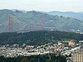
San Francisco's Richmond District in foreground, with Golden Gate Bridge, Marin Headlands, and the Presidio in background
-
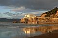
The Cliff House in the Outer Richmond has been rebuilt several times since 1858 and is now a popular restaurant.
-
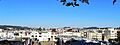
A panorama of the Richmond District seen from the Lincoln Park golf course, looking east.
-
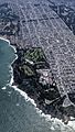
Aerial view looking east of Lands End, Sea Cliff, and the Richmond districts.
-
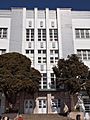
George Washington High School
