Geary Boulevard facts for kids

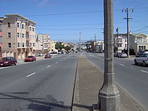
Geary Boulevard, looking eastbound at 36th Avenue, in a residential part of the Richmond District
|
|
| Namesake | John W. Geary |
|---|---|
| Length | 5.8 mi (9.3 km) |
| Location | San Francisco |
| East end | Kearny Street |
| West end | 48th Avenue |
Geary Boulevard is a major street that runs from east to west in San Francisco, California. It's about 5.8 miles (9.3 kilometers) long. The street starts downtown near Market Street and goes all the way to 48th Avenue, close to the Pacific Ocean.
For most of its path, Geary Boulevard goes through the Richmond District. This area is mostly homes, but Geary Boulevard is a busy street with many shops and restaurants. These businesses often serve the different groups of people who live there, like Chinese, Russian, and Irish communities.
The part of the street east of Van Ness Avenue is called Geary Street. Most of Geary Boulevard has traffic going in both directions. However, the section east of Gough Street only allows traffic to go west.
The street was first known as Point Lobos Avenue. It was renamed to honor John W. Geary, who was the first mayor of San Francisco after California became a U.S. state. He also served as governor for both Kansas and Pennsylvania. Geary Boulevard has some of the highest address numbers in San Francisco, with the highest being 8344.
Contents
How Geary Boulevard Began
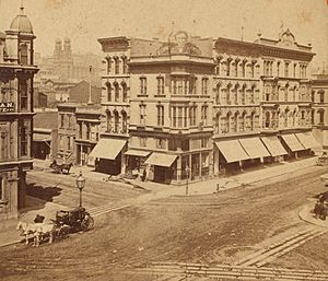
Geary Boulevard started as a simple dirt path for carriages. People used this path to travel to popular spots like the Cliff House and Ocean Beach. Sometimes, horse riders would even race their horses on a flat track next to the road on Sundays.
Cable Cars on Geary Street
From 1880 to 1912, cable cars ran along Geary Street. These special cars were pulled by underground cables. The first cable car line went from Market Street to Central Avenue (now Presidio Avenue). Later, the line was extended to 5th Avenue. Even though it was called the "Geary Street Park & Ocean Railway," it never actually reached the ocean.
Streetcars and Buses
In 1912, the San Francisco Municipal Railway (known as Muni) started its service. Muni ran streetcars on Geary from Market Street all the way to 48th Avenue. These streetcars were a main way for people to get around.
However, in 1956, the streetcar lines were removed. Buses took their place as part of a big city improvement project. Today, the 38 Geary bus line is the busiest bus line in San Francisco. It carries over 50,000 passengers every day!
Modern Roadway Upgrades
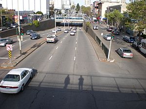
In 1961, a section of Geary Boulevard between Franklin Street and Masonic Avenue was improved. It became an expressway, which is a road designed for faster traffic. This part of the boulevard has many lanes and special bridges or tunnels to separate traffic at major crossings.
Future of Geary Boulevard: Bus Rapid Transit
What is Bus Rapid Transit?
Bus rapid transit (BRT) is a special bus system designed to be faster and more efficient than regular bus lines. It often uses dedicated lanes, so buses don't get stuck in traffic. This helps people travel more quickly.
Plans for Geary BRT
Muni has been studying the idea of adding a BRT line on Geary Boulevard. The plan is to create a BRT corridor between Van Ness Avenue and 33rd Avenue. This new system is expected to be ready around 2022.
The dedicated bus lanes for the BRT are being built so that they could be changed into a streetcar line in the future. This means the city is thinking ahead about how people will travel on Geary Boulevard for many years to come.
 | Sharif Bey |
 | Hale Woodruff |
 | Richmond Barthé |
 | Purvis Young |


