El Jebel, Colorado facts for kids
Quick facts for kids
El Jebel, Colorado
|
|
|---|---|

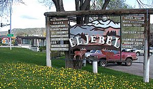
El Jebel sign.
|
|

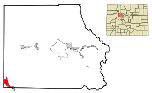
Location of the El Jebel CDP in Eagle County, Colorado.
|
|
| Country | |
| State | |
| County | Eagle County |
| Government | |
| • Type | unincorporated community |
| Area | |
| • Total | 5.359 sq mi (13.880 km2) |
| • Land | 5.305 sq mi (13.739 km2) |
| • Water | 0.054 sq mi (0.141 km2) |
| Elevation | 6,634 ft (2,022 m) |
| Population
(2020)
|
|
| • Total | 4,130 |
| • Density | 770.7/sq mi (297.6/km2) |
| Time zone | UTC-7 (MST) |
| • Summer (DST) | UTC-6 (MDT) |
| ZIP Code |
81623
|
| Area code(s) | 970 |
| GNIS feature | 2408058 |
El Jebel is a small community in Eagle County, Colorado, United States. It's not a city or town with its own government. Instead, it's called an "unincorporated community" and a "census-designated place" (CDP). This means the United States Census Bureau tracks its population. In 2020, about 4,130 people lived there. El Jebel is part of the larger Edwards, CO area. The local post office uses the ZIP Code 81623.
Contents
History of El Jebel
El Jebel grew a lot in the late 1900s. This happened as more people moved to the valley near Aspen. Today, El Jebel has many shops and businesses. These are located right off Colorado State Highway 82. You can find it about 3 miles (4.8 km) northwest of Basalt. There are also several neighborhoods with homes nearby.
What Does "El Jebel" Mean?
The name "El Jebel" comes from the Arabic language. It means "the mountain."
Where is El Jebel Located?
El Jebel is in the Roaring Fork Valley. It sits between the towns of Carbondale and Basalt. You can find it along the north side of Colorado State Highway 82.
The El Jebel area covers about 13.880 square kilometers (5.359 sq mi). A small part of this, about 0.141 square kilometers (0.054 sq mi), is water.
El Jebel's Climate
El Jebel has a subarctic climate. This means winters are long and very cold. Days are short and clear during this time. There isn't much rain, mostly snow. The air is also quite dry.
| Climate data for El Jebel, Colorado | |||||||||||||
|---|---|---|---|---|---|---|---|---|---|---|---|---|---|
| Month | Jan | Feb | Mar | Apr | May | Jun | Jul | Aug | Sep | Oct | Nov | Dec | Year |
| Mean daily maximum °C (°F) | 1 (33) |
4 (39) |
9 (48) |
14 (58) |
21 (69) |
26 (78) |
30 (86) |
28 (83) |
24 (75) |
17 (63) |
8 (47) |
1 (34) |
16 (60) |
| Mean daily minimum °C (°F) | −9 (15) |
−7 (20) |
−3 (27) |
2 (35) |
6 (43) |
10 (50) |
14 (58) |
13 (56) |
9 (48) |
3 (38) |
−3 (27) |
−8 (18) |
2 (36) |
| Average precipitation mm (inches) | 43 (1.7) |
38 (1.5) |
43 (1.7) |
53 (2.1) |
43 (1.7) |
30 (1.2) |
30 (1.2) |
43 (1.7) |
43 (1.7) |
46 (1.8) |
41 (1.6) |
41 (1.6) |
500 (19.5) |
| Source: Weatherbase | |||||||||||||
Population Changes in El Jebel
The United States Census Bureau first counted El Jebel's population in 1990. This is how the number of people living there has changed over the years:
| El Jebel CDP, Colorado | ||
|---|---|---|
| Year | Pop. | ±% |
| 1990 | 2,605 | — |
| 2000 | 4,488 | +72.3% |
| 2010 | 3,801 | −15.3% |
| 2020 | 4,130 | +8.7% |
| Source: United States Census Bureau | ||
See also
 In Spanish: El Jebel para niños
 | John T. Biggers |
 | Thomas Blackshear |
 | Mark Bradford |
 | Beverly Buchanan |


