Eagle, Colorado facts for kids
Quick facts for kids
Eagle, Colorado
|
|
|---|---|

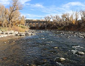
The Eagle River flows through Chambers Park in Eagle
|
|
| Motto(s):
“Classic Colorado”
|
|

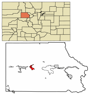
Location of the Town of Eagle in Eagle County, Colorado.
|
|
| Country | |
| State | |
| County | Eagle County seat |
| Incorporated (town) | April 5, 1905 |
| Government | |
| • Type | Home rule municipality |
| Area | |
| • Total | 5.661 sq mi (14.663 km2) |
| • Land | 5.641 sq mi (14.611 km2) |
| • Water | 0.020 sq mi (0.052 km2) |
| Elevation | 6,683 ft (2,037 m) |
| Population
(2020)
|
|
| • Total | 7,511 |
| • Density | 1,331/sq mi (514/km2) |
| • Metro | 55,731 |
| • CSA | 134,774 |
| Time zone | UTC−07:00 (MST) |
| • Summer (DST) | UTC−06:00 (MDT) |
| ZIP code |
81631 (PO Box)
|
| Area code(s) | 970 |
| INCITS place code | 0822200 |
| GNIS feature ID | 2412456 |
| FIPS code | 08-22200 |
Eagle is a town in Colorado, United States. It is the main town of Eagle County, Colorado. In 2020, about 7,511 people lived there. This was a 15% increase from 2010. Eagle is part of a larger area called the Edwards, CO Micropolitan Statistical Area.
The town is known for its many trails. These trails are great for mountain biking, hiking, and trail running.
Contents
History of Eagle
The town of Eagle got its name from Eagle County, Colorado. A post office was opened here in 1891. Eagle officially became a town in 1905.
Geography of Eagle
Eagle is located in the western part of Eagle County, Colorado. It sits in the valley of the Eagle River. This river flows west and joins the Colorado River. The town also extends south along Brush Creek.
U.S. Route 6 goes through the middle of Eagle. Interstate 70 runs along the northern side of the town. You can get to Eagle from Exit 147 on Interstate 70. The town of Vail is about 30 miles (48 km) to the east. Glenwood Springs is about 31 miles (50 km) to the west.
The town covers a total area of about 4.6 square miles (11.9 km2). A small part of this area, about 0.02 square miles (0.05 km2), is water.
Population of Eagle
| Historical population | |||
|---|---|---|---|
| Census | Pop. | %± | |
| 1900 | 124 | — | |
| 1910 | 186 | 50.0% | |
| 1920 | 358 | 92.5% | |
| 1930 | 341 | −4.7% | |
| 1940 | 518 | 51.9% | |
| 1950 | 445 | −14.1% | |
| 1960 | 546 | 22.7% | |
| 1970 | 790 | 44.7% | |
| 1980 | 950 | 20.3% | |
| 1990 | 1,580 | 66.3% | |
| 2000 | 3,032 | 91.9% | |
| 2010 | 6,508 | 114.6% | |
| 2020 | 7,511 | 15.4% | |
| U.S. Decennial Census | |||
In 2010, there were 6,508 people living in Eagle. There were 2,183 households, and 1,666 families. The town had about 1,417.9 inhabitants per square mile (547.5/km2) people per square mile.
Many households had children under 18 living with them. Most families were married couples living together. The average household had about 2.96 people. The average family had about 3.33 people.
The population was spread out by age. About 31.7% of the people were under 18. About 35.8% were between 25 and 44 years old. The average age in Eagle was 33.8 years.
Community Involvement
The people of Eagle are very involved in their community. They often speak up when important decisions need to be made. For example, they have voted on big projects several times.
A referendum is when people vote directly on a law or decision. In Eagle, voters have used referendums to decide on things like:
- A large shopping and entertainment area called Eagle River Station. Voters first said no to a plan in 2010.
- Allowing a special business to stay open in 2012.
- Later in 2012, voters approved a new plan for the Eagle River Station project.
Getting Around Eagle
Eagle has several ways to travel to and from the town.
Air Travel
Eagle County Regional Airport (EGE) is about 5 miles (8 km) west of Eagle. It is located between Eagle and the town of Gypsum. During the ski season, many airlines fly to Eagle from different places. In other months, flights mainly go to Dallas and Denver.
Bus Services
ECO Transit provides local bus service. You can travel from Eagle to nearby towns like Dotsero, Gypsum, Edwards, Avon, and Vail.
Bustang is Colorado's state-run bus service. It connects Eagle to larger cities like Grand Junction and Denver.
Roads
- Interstate 70 (I-70) runs east and west. It connects Eagle to many major cities across the United States.
- U.S. Highway 6 also runs east and west. It goes through Eagle County, parallel to Interstate 70.
Railroad
Union Pacific Railroad tracks go through Eagle. These tracks connect the town to cities like Denver, Grand Junction, and Pueblo. The closest Amtrak train station is in Glenwood Springs. It is about 31 miles (50 km) west of Eagle. The California Zephyr train stops there daily.
Famous People from Eagle
- Benjamin Kunkel (born 1972), a writer and expert in economics.
See also
 In Spanish: Eagle (Colorado) para niños
 | James Van Der Zee |
 | Alma Thomas |
 | Ellis Wilson |
 | Margaret Taylor-Burroughs |


