Burns, Colorado facts for kids
Quick facts for kids
Burns, Colorado
|
|
|---|---|

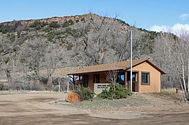
The post office in Burns.
|
|
| Country | |
| State | |
| County | Eagle County |
| Elevation | 6,496 ft (1,980 m) |
| Time zone | UTC-7 (MST) |
| • Summer (DST) | UTC-6 (MDT) |
| Zip code |
80426
|
Burns is a small, quiet place in northern Eagle County, Colorado, United States. It is called an "unincorporated community" because it doesn't have its own local government like a town or city.
Contents
Exploring Burns: A Remote Colorado Community
Burns is located along the Colorado River. This area is quite remote, meaning it's far from big cities. It lies southwest of a town called Kremmling.
Getting to Burns: Roads and Rivers
To reach Burns, you need to travel on dirt and gravel roads. These roads connect to State Highway 131 and Interstate 70. The community sits in a dry creek bed, also known as an arroyo, right by the river. The Union Pacific Railroad also runs through this area. You can see beautiful sandstone canyons all around.
What You'll Find in Burns
Burns is a very small community. It has a U.S. Post Office where people get their mail. The postal code for Burns is 80426. There is also a church in the area. The main way people make a living here is through raising livestock, like cattle, on ranches.
The Story of Burns: A Look at Its Past
Burns got its name from a man named Jack Burns. He was a trapper who built a cabin in this area a long time ago.
When Burns Got Its Post Office
The Post Office in Burns first opened its doors on May 14, 1895. This was an important step for the community, making it easier for people to send and receive letters.
Where in the World is Burns? Geography Facts
Burns is located at specific geographic coordinates: 39 degrees, 52 minutes, 24 seconds North latitude and 106 degrees, 52 minutes, 55 seconds West longitude. This helps pinpoint its exact spot on a map.
 | Stephanie Wilson |
 | Charles Bolden |
 | Ronald McNair |
 | Frederick D. Gregory |


