Moffat County, Colorado facts for kids
Quick facts for kids
Moffat County
|
|
|---|---|

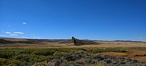
Round Bottom Area in Moffat County, Colorado
|
|

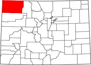
Location within the U.S. state of Colorado
|
|
 Colorado's location within the U.S. |
|
| Country | |
| State | |
| Founded | February 27, 1911 |
| Named for | David H. Moffat |
| Seat | Craig |
| Largest city | Craig |
| Area | |
| • Total | 4,751 sq mi (12,310 km2) |
| • Land | 4,743 sq mi (12,280 km2) |
| • Water | 7.6 sq mi (20 km2) 0.2%% |
| Population
(2020)
|
|
| • Total | 13,292 |
| • Estimate
(2024)
|
13,142 |
| • Density | 2.7977/sq mi (1.08021/km2) |
| Time zone | UTC−7 (Mountain) |
| • Summer (DST) | UTC−6 (MDT) |
| Congressional district | 3rd |
Moffat County is a county located in the state of Colorado, United States. In 2020, about 13,292 people lived here. The main town and county seat is Craig. Moffat County is very large, covering 4,751 square miles. It is the second-biggest county in Colorado by land area.
Contents
History of Moffat County
Early People and Land Changes
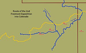
The first people known to live in this part of Colorado were the Ute tribes. In the 1700s, Spanish explorers passed nearby and noted the area. Later, in the early 1800s, trappers like William Henry Ashley explored the Green River area. John C. Frémont led the first organized exploration of the county in 1844.
Even with explorers arriving, treaties in 1868 and 1873 said that northwestern Colorado was part of the Ute Nation. However, in 1879, a U.S. agent named Nathan Meeker tried to change the Ute people's traditional way of life. This led to a conflict where Meeker and his staff were killed. After this event, the U.S. government moved most of the Ute tribes to Utah. This opened up the land for mining, ranching, and new settlers.
How the County Was Formed
In 1861, the Colorado Territory was created, and this area became part of Summit County. Over the years, the land was divided several times. In 1874, Grand County was formed from Summit County. Then, in 1877, Routt County was created from Grand County. Finally, in 1911, Moffat County was created from the western part of Routt County. The county was named after David H. Moffat, a well-known Colorado businessman who passed away in 1911.
Growth and Transportation
David Moffat was important for trying to build a railroad from Denver to Salt Lake City. His railroad, the Denver and Salt Lake Railway, reached Craig in Moffat County in 1913. This railroad helped cattle ranchers in the early days. However, the track never went all the way to Utah.
In the 1920s, U.S. Route 40 was built. This major highway passed through Craig, making it a stop between Denver and Salt Lake City. This helped Craig's economy by bringing in travelers and tourism. Later, the main interstate highways, Interstate 80 and Interstate 70, were built through other areas. This left Moffat County on a secondary highway, not on the main routes.
Moffat County's population stayed around 5,000 people until the 1970s. At that time, three large power plants that used coal were built. These plants brought more people and jobs. However, these power plants are planned to close between 2025 and 2030. This will have a big effect on the county's economy. Besides energy, ranching, farming, and tourism are also important industries in Moffat County.
Geography
Moffat County covers a total area of 4,751 square miles. Most of this is land, with only a small amount of water. It is the second-largest county in Colorado by land area.
Neighboring Counties
- Routt County – east
- Rio Blanco County – south
- Uintah County, Utah – west
- Daggett County, Utah – west
- Sweetwater County, Wyoming – north
- Carbon County, Wyoming – north
Main Roads
 U.S. Highway 40
 State Highway 13
 State Highway 317
 State Highway 318
 State Highway 394
 Wyoming Highway 70
Protected Natural Areas
- Browns Park National Wildlife Refuge
- Dinosaur National Monument
- Routt National Forest
- White River National Forest
- Yampa River State Park
Scenic Drives
- Dinosaur Diamond Prehistoric Highway National Scenic Byway
Population Information
| Historical population | |||
|---|---|---|---|
| Census | Pop. | %± | |
| 1920 | 5,129 | — | |
| 1930 | 4,861 | −5.2% | |
| 1940 | 5,086 | 4.6% | |
| 1950 | 5,946 | 16.9% | |
| 1960 | 7,061 | 18.8% | |
| 1970 | 6,525 | −7.6% | |
| 1980 | 13,133 | 101.3% | |
| 1990 | 11,357 | −13.5% | |
| 2000 | 13,184 | 16.1% | |
| 2010 | 13,795 | 4.6% | |
| 2020 | 13,292 | −3.6% | |
| 2024 (est.) | 13,142 | −4.7% | |
| U.S. Decennial Census 1790–1960 1900–1990 1990–2000 2010–2020 |
|||
In 2000, there were 13,184 people living in Moffat County. About 38% of households had children under 18. The average age of people in the county was 35 years old.
Towns and Communities
Cities and Towns
Other Communities
Politics
Moffat County usually votes for the Republican Party in presidential elections. Since 1964, no Democratic presidential candidate has won the county. In most elections, Republican candidates have received more than half of the votes.
| Year | Republican | Democratic | Third party | |||
|---|---|---|---|---|---|---|
| No. | % | No. | % | No. | % | |
| 2024 | 5,358 | 80.32% | 1,167 | 17.49% | 146 | 2.19% |
| 2020 | 5,670 | 80.70% | 1,203 | 17.12% | 153 | 2.18% |
| 2016 | 5,305 | 81.30% | 874 | 13.39% | 346 | 5.30% |
| 2012 | 4,695 | 76.12% | 1,330 | 21.56% | 143 | 2.32% |
| 2008 | 4,135 | 70.43% | 1,582 | 26.95% | 154 | 2.62% |
| 2004 | 4,247 | 74.18% | 1,355 | 23.67% | 123 | 2.15% |
| 2000 | 3,840 | 71.95% | 1,223 | 22.92% | 274 | 5.13% |
| 1996 | 2,466 | 50.99% | 1,635 | 33.81% | 735 | 15.20% |
| 1992 | 1,809 | 35.51% | 1,386 | 27.20% | 1,900 | 37.29% |
| 1988 | 2,757 | 61.01% | 1,634 | 36.16% | 128 | 2.83% |
| 1984 | 3,630 | 72.88% | 1,228 | 24.65% | 123 | 2.47% |
| 1980 | 3,344 | 67.90% | 1,079 | 21.91% | 502 | 10.19% |
| 1976 | 2,099 | 55.68% | 1,451 | 38.49% | 220 | 5.84% |
| 1972 | 1,928 | 67.70% | 591 | 20.75% | 329 | 11.55% |
| 1968 | 1,785 | 62.09% | 765 | 26.61% | 325 | 11.30% |
| 1964 | 1,438 | 46.34% | 1,657 | 53.40% | 8 | 0.26% |
| 1960 | 1,754 | 59.32% | 1,200 | 40.58% | 3 | 0.10% |
| 1956 | 1,762 | 68.80% | 797 | 31.12% | 2 | 0.08% |
| 1952 | 1,922 | 70.12% | 808 | 29.48% | 11 | 0.40% |
| 1948 | 1,261 | 52.74% | 1,101 | 46.05% | 29 | 1.21% |
| 1944 | 1,445 | 60.87% | 923 | 38.88% | 6 | 0.25% |
| 1940 | 1,556 | 59.23% | 1,056 | 40.20% | 15 | 0.57% |
| 1936 | 954 | 42.14% | 1,090 | 48.14% | 220 | 9.72% |
| 1932 | 880 | 36.56% | 1,388 | 57.67% | 139 | 5.77% |
| 1928 | 1,346 | 64.56% | 710 | 34.05% | 29 | 1.39% |
| 1924 | 1,009 | 50.70% | 647 | 32.51% | 334 | 16.78% |
| 1920 | 1,294 | 65.42% | 589 | 29.78% | 95 | 4.80% |
| 1916 | 512 | 39.72% | 740 | 57.41% | 37 | 2.87% |
| 1912 | 294 | 31.34% | 409 | 43.60% | 235 | 25.05% |
More to Explore
- Bibliography of Colorado
- Geography of Colorado
- History of Colorado
- Index of Colorado-related articles
- List of counties in Colorado
- List of statistical areas in Colorado
- Outline of Colorado
See also
 In Spanish: Condado de Moffat para niños
 | Roy Wilkins |
 | John Lewis |
 | Linda Carol Brown |


