
Steamboat Rock (Colorado) facts for kids
Quick facts for kids Steamboat Rock |
|
|---|---|

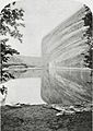
Steamboat Rock, south aspect
|
|
| Highest point | |
| Elevation | 6,074 ft (1,851 m) |
| Prominence | 294 ft (90 m) |
| Isolation | 0.9 mi (1.4 km) |
| Parent peak | Jenny Lind Rock |
| Geography | |

Steamboat Rock
Location in Colorado

Steamboat Rock
Location in the United States
|
|
| Location | Dinosaur National Monument Moffat County, Colorado, US |
| Parent range | Uinta Mountains |
| Topo map | USGS Canyon of Lodore South |
| Geology | |
| Age of rock | Permian-Pennsylvanian |
| Type of rock | Weber Sandstone |
| Climbing | |
| Easiest route | class 5+ climbing |
Steamboat Rock is a tall, impressive rock formation, standing 6,074 feet (1,851 meters) high. You can find it in northwest Colorado, United States, within the Uinta Mountains. It's a famous spot in Dinosaur National Monument, right where the Green River and Yampa River meet. Rain and snow that fall on Steamboat Rock flow into the Green River.
This amazing rock was first called "Echo Rock" by explorer John Wesley Powell in his 1875 book about exploring the Colorado River. The name "Steamboat Rock" first appeared on a map in 1941. The area around it is still known as Echo Park, a name Powell gave it during his 1869 expedition.
What is Steamboat Rock Made Of?
Steamboat Rock is a long, narrow ridge that stretches for about a mile and rises 1,000 feet high. It sits inside a big bend of the Green River. This rock is mostly made of a type of stone called Weber Sandstone. This sandstone formed a very long time ago, during the Permian and Pennsylvanian periods.
At the very top of Steamboat Rock, there's a thin layer of Park City Formation rock. The Green River flows out of Lodore Canyon and then enters Echo Park right where Steamboat Rock is. As the river goes around Steamboat Rock, it drops about 15 feet.
Weather Around Steamboat Rock
The best times to visit Steamboat Rock are in the spring and fall. The area has a semi-arid climate, which means it's pretty dry, like a high desert.
In January, the coldest month, temperatures usually range from 0°F to 30°F (about -18°C to -1°C). In July, the hottest month, temperatures can be anywhere from 50°F to 100°F (about 10°C to 38°C). Summers can get very hot, and winters can be very cold.
Snow often falls, but it usually melts quickly because the climate is sunny and dry. Even though the area gets more than 10 inches of rain each year, it's still considered a desert because the water evaporates so quickly.
| Climate data for Dinosaur National Monument | |||||||||||||
|---|---|---|---|---|---|---|---|---|---|---|---|---|---|
| Month | Jan | Feb | Mar | Apr | May | Jun | Jul | Aug | Sep | Oct | Nov | Dec | Year |
| Mean daily maximum °F (°C) | 33.0 (0.6) |
39.0 (3.9) |
50.4 (10.2) |
60.8 (16.0) |
71.9 (22.2) |
83.2 (28.4) |
90.5 (32.5) |
87.9 (31.1) |
77.7 (25.4) |
63.6 (17.6) |
45.7 (7.6) |
34.2 (1.2) |
61.5 (16.4) |
| Mean daily minimum °F (°C) | 10.8 (−11.8) |
15.2 (−9.3) |
25.0 (−3.9) |
31.8 (−0.1) |
40.5 (4.7) |
48.9 (9.4) |
56.6 (13.7) |
54.7 (12.6) |
45.5 (7.5) |
34.9 (1.6) |
23.3 (−4.8) |
12.7 (−10.7) |
33.3 (0.7) |
| Average precipitation inches (mm) | 0.64 (16) |
0.56 (14) |
0.88 (22) |
1.17 (30) |
1.30 (33) |
1.06 (27) |
1.01 (26) |
0.89 (23) |
1.24 (31) |
1.46 (37) |
0.80 (20) |
0.62 (16) |
11.64 (296) |
| Average snowfall inches (cm) | 9.2 (23) |
6.6 (17) |
5.9 (15) |
3.5 (8.9) |
0.7 (1.8) |
0.2 (0.51) |
0.0 (0.0) |
0.0 (0.0) |
0.2 (0.51) |
1.6 (4.1) |
4.7 (12) |
8.3 (21) |
41.1 (104) |
| Source: The Western Regional Climate Center | |||||||||||||
- Steamboat Rock: Weather forecast
Images for kids
-

Steamboat Rock from the south-southwest
-
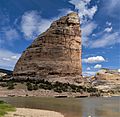
Another view from the south-southwest
-

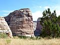
The southern end of Steamboat Rock
-
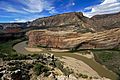
Where the Green and Yampa Rivers meet, below Steamboat Rock's east wall
-
A view from the southwest
-
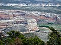
Steamboat Rock seen from the west
-
The oldest known picture of Steamboat Rock, taken in 1871


.jpg)


