
Rabbit Ears Pass facts for kids
Quick facts for kids Rabbit Ears Pass |
|
|---|---|

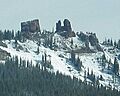
View of Rabbit Ears Peak from the Pass
|
|
| Elevation | 2,873 m (9,426 ft) |
| Traversed by | |
| Location | Grand / Routt counties, Colorado, United States |
| Range | Rocky Mountains |
| Topo map | Terraserver map |

Rabbit Ears Pass is a high mountain pass in the Rocky Mountains of northern Colorado, United States. It sits at an elevation of 9,426 feet (2,873 meters). The pass gets its name from two large rock formations at the top that look like rabbit ears. These unique rocks are made of volcanic material.
Contents
Building the Road Through Rabbit Ears Pass
The area around Rabbit Ears Pass covers about 56 square miles in north-central Colorado. The highway over the pass is a very important road. It connects different parts of the country.
Building this road was a big project. The state of Colorado, along with Routt, Grand, and Jackson counties, and the U.S. Forest Service, worked together. Construction started in 1911 and finished in 1917. Today, workers continue to improve the road. They make curves less sharp and fix the road surface.
The road links Routt County with Jackson and Grand counties. It also provides a direct route to Denver. To reach Denver, you travel through Kremmling and over Berthoud Pass.
Location and Connection
Rabbit Ears Pass is located on the Continental Divide. This is a line that separates rivers flowing to the Atlantic Ocean from those flowing to the Pacific Ocean. The pass is at the southern end of the Park Range.
The name "Rabbit Ears Pass" comes from Rabbit Ears Peak. This mountain is part of the Park Range to the north. You can see it clearly from the east side of the pass on a nice day.
The pass separates two river basins:
- The upper Yampa River basin to the west.
- North Park and the upper North Platte River basin to the east.
U.S. Highway 40 crosses over Rabbit Ears Pass. It connects Steamboat Springs and Kremmling. This highway crosses the Continental Divide in three places:
- Rabbit Ears Pass
- Nearby Muddy Pass to the southeast
- The higher Berthoud Pass closer to Denver
Nature and Wildlife
The climate at Rabbit Ears Pass ranges from dry to humid. The area is mostly covered with pine, spruce, and aspen trees. Sagebrush also grows in some places. The plants here can be very thick.
Trees and Beetles
Like many places in the western U.S., Rabbit Ears Pass has seen a decline in Englemann spruce trees. This is due to outbreaks of the spruce bark beetle. These tiny beetles attack and kill spruce trees.
Major spruce beetle outbreaks have happened many times in this area. Some known outbreaks were in:
- 1716-1750
- 1827-1845
- 1860-1870
- 1940-1960
During these outbreaks, spruce beetles can also attack lodgepole pine trees. Most trees that are attacked do not survive.
Animal Life

Rabbit Ears Pass is home to many different animal species. It provides important areas for animals to live in both winter and summer.
You might see animals like:
- Elk
- Mule deer
- Moose
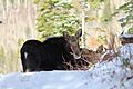
- Black bears
- Foxes
- Long-tailed weasels
- Snowshoe hares
- Many types of birds
In winter, the deep snowpack creates a special habitat. Many burrowing animals that do not hibernate live here. These include voles, lemmings, and shrews. The snow acts like a warm blanket. It creates a subnivean zone underneath. This zone is full of air, which helps keep the animals warm.
Fun Activities at Rabbit Ears Pass

Even though Rabbit Ears Pass is not as high as some other Colorado passes, it gets a lot of snow. Because of heavy winter storms, the pass sometimes closes for short periods. The snow that falls here is a major source of water for nearby communities.
Rabbit Ears Pass is a great place for many outdoor activities.
Winter Sports
In winter, it's a popular spot for:
- Backcountry snowboarding and skiing
- Cross-country skiing
- Snowshoeing
To keep everyone safe, there are rules about where different activities can happen. Some areas are for snowmobiles and other motorized vehicles. Other areas are just for people on foot. These rules help prevent problems between different users. They also protect animal wintering areas.
Motorized recreation is allowed east of the pass. Non-motorized recreation is allowed west of the pass. The U.S. Department of Agriculture (USDA) Forest Service manages the Routt National Forest. They have rules for when the snowmobile season can start. The snow must be at least 12 inches (30 cm) deep. This helps protect the habitat.
Summer Adventures

In the summer, the pass offers many activities:
- Run Rabbit Run: This is a popular 50-mile or 100-mile trail run.
- Camping: There are many places for car camping.
- Hiking: Lots of trails to explore.
- Road Biking: This is one of the most popular summer sports.
Steamboat Springs often hosts a stage of the USA Pro Cycling Tour. This international bike race brings riders over the pass. They descend into Steamboat Springs at the end of a stage. They then climb over the pass at the start of the next stage.
The pass also hosts the "Ride the Divide" Mountain bike race. This race goes from Montana all the way to Mexico every year. The trail over the pass starts at 10,038 feet (3060 meters) at Base Camp Trailhead. It ends at 9,250 feet (2819 meters) in the Medicine Bow National Forest, Wyoming. This trail is 68.1 miles (99.5 km) long. It offers amazing views to the east into North Park and to the west towards Utah. Always be ready for extreme weather when you are out on the trails.
The Road Over the Pass
The highway over Rabbit Ears Pass is a bit unusual. Near the top, it has gentle ups and downs. After crossing the Continental Divide going west, the road dips down. Then it reaches its highest point, about 9,520 feet. After that, it gently goes down to the west summit (9,400 feet). Finally, it drops steeply towards Steamboat Springs. This steep section has a 6.8% grade. It is the 28th steepest pass in Colorado.
Because of the steep drop of 3,000 feet in seven miles, there are many sharp curves. There is also a special runaway truck ramp. This ramp is for truckers whose brakes get too hot while going down the steep hill. The eastern side of the pass is much less steep. It goes down slowly towards Muddy Pass.

The current highway crossing is a newer route. The old highway used to cross the Divide a bit higher up to the north. You can still reach the old Rabbit Ears Pass. Turn north off U.S. 40 towards Dumont Lake. A stone monument marks the old summit. The old highway is now Grand County Road 199. From the old summit, you can easily get to the base of Rabbit Ears Peak using 4x4 trails.
Images for kids
-
View of Rabbit Ears Peak from the Pass
-
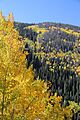
Rabbit Ears Pass in Colorado
-
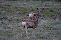
Mule deer are often seen on the pass.
-
A cow and bull moose on Rabbit Ears Pass
-
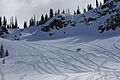
Rabbit Ears Pass is a great place for snowmobiling in Northwest Colorado.
-
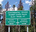
A sign marking the Continental Divide at Rabbit Ears Pass
