Berthoud Pass facts for kids
Quick facts for kids Berthoud Pass |
|
|---|---|
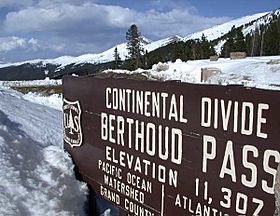
View from the summit of Berthoud Pass
|
|
| Elevation | 11,307 ft (3,446 m) |
| Traversed by | |
| Location | Clear Creek / Grand counties, Colorado, United States |
| Range | Rocky Mountains |
| Coordinates | 39°47′52″N 105°46′37″W / 39.79778°N 105.77694°W |
Berthoud Pass (pronounced BURTH-əd) is a high mountain pass in the middle of Colorado. It's part of the Rocky Mountains in the western United States. This pass is very high up, reaching an elevation of 11,307 ft (3,446 m).
The pass is located west of Denver. It connects the upper Clear Creek Canyon area with the upper valley of the Fraser River. This river is in a place called Middle Park to the north. Berthoud Pass crosses the continental divide at the Front Range. This means it's where waters on one side flow to the Atlantic Ocean and waters on the other side flow to the Pacific Ocean. It sits on the border between Clear Creek County and Grand County.
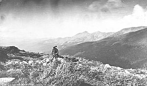
The pass is named after Edward L. Berthoud. He was a main surveyor for the Colorado Central Railroad in the 1870s. Edward Berthoud found the pass in July 1861. He was with Jim Bridger at the time. They were looking for a possible railroad route. Berthoud thought the pass would work for wagons, but not for a train. Later, he was hired to map a wagon route over the pass to Salt Lake City.
Today, U.S. Highway 40 goes over Berthoud Pass. This highway is north of where it meets Interstate 70. The pass offers the quickest way to get to Winter Park. It's also a second way to reach Steamboat Springs from Denver.
However, Berthoud Pass is known for being tough for drivers. It's very high up, and both sides have steep slopes (6.3%). There are also many sharp turns called switchbacks on the southern side. Over 55 paths where avalanches can happen have been found on the pass. Some of these paths cross U.S. Highway 40. In 2015, the CDOT put in a special system. It uses propane to create blasts that help prevent snow from building up and causing avalanches.
Berthoud Pass Ditch: Moving Water
In 1902, something called the Berthoud Pass Ditch was built. This ditch is about 3.5 miles (5.6 km) long. It was made to move water from the Fraser River. The water was sent over the continental divide into the Clear Creek area.
At first, this water was used to help farmers grow crops. But in the mid-1980s, the cities of Northglenn and Golden bought the ditch. The ditch can carry a lot of water, about 53.4 cubic feet per second. In 1999, the ditch was blocked when a tunnel under the parking lot collapsed. But it was fixed the next year. Since then, the ditch usually moves about 500 acre-feet of water each year.
Berthoud Pass Ski Area: A Mountain Playground
Berthoud Pass used to have a ski resort called Berthoud Pass Ski Area. It's not open anymore. But the pass is still a popular spot for people who love to ski, snowboard, and snowshoe in the backcountry. This means they go off the groomed trails. The area has lots of steep and exciting slopes. It also gets a lot of snow, averaging 500 inches each year.
The winding road on both sides of the pass is helpful for skiers. They can use "car shuttles" to get back to the top after skiing down. This means they don't have to hike all the way back up.
The ski resort closed in 2002 because of money problems. There were also issues with getting enough water and sewage services at the top of the pass. In 2003, the ski lifts were taken down. Some people still skied there using special snowcats to get up the mountain.
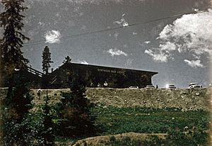
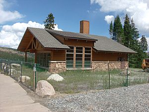
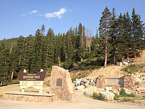
In 2005, the Colorado DOT started a project to return the area to its natural state. One of the first things they did was tear down the old lodge. A new warming hut was opened at the top of the pass in May 2008. There's also a bigger parking area now. Plus, two new spots to enjoy the views and a new sign marking the summit. The old ski lodge had been used since the early 1950s. The new warming hut has modern features like special composting toilets and heated floors.
Some people say Berthoud Ski Resort was the very first resort and ski lift in Colorado. Others claim it was the first resort to openly welcome snowboarders. The summit of Berthoud Pass is located at about 39°47′53.70″N 105°46′36.88″W / 39.7982500°N 105.7769111°W.
Climate: Weather at the Top
Berthoud Pass has a very cold mountain climate. It has short summers with nice days but cold nights. The winters are long and get a huge amount of snow. The average snowfall each year is 391.2 inches or 9.94 metres. From November to May, every month gets at least 37 inches or 0.94 metres of snow.
In one year, from July 1983 to June 1984, the snowfall reached 523.4 inches or 13.29 metres. This included 123 inches or 3.12 metres in December 1983 alone! The snow can pile up very deep, often over 55 inches or 1.40 metres. It has even been more than 110 inches or 2.79 metres deep at times.
| Climate data for Berthoud Pass, Colorado (Elevation 11,313 feet or 3,448 metres) | |||||||||||||
|---|---|---|---|---|---|---|---|---|---|---|---|---|---|
| Month | Jan | Feb | Mar | Apr | May | Jun | Jul | Aug | Sep | Oct | Nov | Dec | Year |
| Record high °F (°C) | 42 (6) |
47 (8) |
50 (10) |
57 (14) |
62 (17) |
70 (21) |
76 (24) |
75 (24) |
73 (23) |
63 (17) |
54 (12) |
47 (8) |
76 (24) |
| Mean daily maximum °F (°C) | 21.2 (−6.0) |
24.2 (−4.3) |
28.7 (−1.8) |
36.2 (2.3) |
45.0 (7.2) |
54.2 (12.3) |
61.9 (16.6) |
59.9 (15.5) |
53.0 (11.7) |
42.4 (5.8) |
30.4 (−0.9) |
23.2 (−4.9) |
40.0 (4.4) |
| Mean daily minimum °F (°C) | 1.4 (−17.0) |
2.0 (−16.7) |
6.2 (−14.3) |
13.6 (−10.2) |
23.1 (−4.9) |
32.0 (0.0) |
39.2 (4.0) |
38.0 (3.3) |
31.0 (−0.6) |
20.9 (−6.2) |
9.8 (−12.3) |
3.2 (−16.0) |
18.4 (−7.6) |
| Record low °F (°C) | −33 (−36) |
−34 (−37) |
−24 (−31) |
−12 (−24) |
−3 (−19) |
11 (−12) |
26 (−3) |
21 (−6) |
4 (−16) |
−5 (−21) |
−28 (−33) |
−30 (−34) |
−34 (−37) |
| Average precipitation inches (mm) | 3.49 (89) |
2.90 (74) |
4.11 (104) |
4.43 (113) |
3.85 (98) |
2.23 (57) |
2.45 (62) |
2.63 (67) |
2.05 (52) |
2.36 (60) |
3.36 (85) |
3.63 (92) |
37.48 (952) |
| Average snowfall inches (cm) | 49.8 (126) |
42.4 (108) |
57.9 (147) |
54.6 (139) |
37.2 (94) |
11.8 (30) |
0 (0) |
0.3 (0.76) |
8.7 (22) |
28.0 (71) |
49.1 (125) |
51.4 (131) |
391.2 (994) |
| Source: The Western Regional Climate Center | |||||||||||||
 | Madam C. J. Walker |
 | Janet Emerson Bashen |
 | Annie Turnbo Malone |
 | Maggie L. Walker |


