Granby, Colorado facts for kids
Quick facts for kids
Granby, Colorado
|
|||
|---|---|---|---|
| Town of Granby | |||

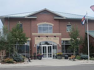
Granby Town Hall
|
|||
|
|||
| Motto(s):
"The heart of something grand"
|
|||

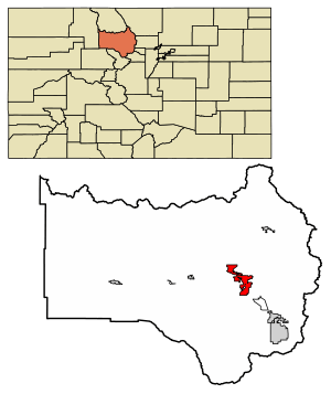
Location of the Town of Granby in Grand County, Colorado.
|
|||
| Country | |||
| State | |||
| County | Grand County | ||
| Founded | 1905 | ||
| Incorporated (town) | December 11, 1905 | ||
| Government | |||
| • Type | Statutory Town | ||
| Area | |||
| • Total | 12.682 sq mi (32.845 km2) | ||
| • Land | 12.682 sq mi (32.845 km2) | ||
| • Water | 0 sq mi (0.000 km2) | ||
| Elevation | 7,993 ft (2,436 m) | ||
| Population
(2020)
|
|||
| • Total | 2,079 | ||
| • Density | 164/sq mi (63/km2) | ||
| • Grand County | 15,717 | ||
| Time zone | UTC−07:00 (MST) | ||
| • Summer (DST) | UTC−06:00 (MDT) | ||
| ZIP code |
80446
|
||
| Area code(s) | 970 | ||
| FIPS code | 08-31605 | ||
| GNIS feature ID | 2412699 | ||
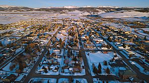
The Town of Granby is a busy town in Grand County, Colorado, United States. It is the largest town in Grand County by population. In 2020, about 2,079 people lived there. Granby is located along U.S. Highway 40 in an area called Middle Park. It is about 85 miles (137 km) northwest of Denver. It is also only 14 miles (23 km) southwest of Rocky Mountain National Park.
Contents
History of Granby
Granby was founded in 1904. It grew up along the Denver, Northwestern & Pacific Railway line. The town was officially made a town (incorporated) one year later in 1905. It was named after Granby Hillyer, a lawyer from Denver. He later became the United States Attorney for Denver's area.
Many people living in Granby today are related to the first settlers. These pioneers arrived before the land was fully mapped out. Early families got land easily through the Homestead Act of 1862. This act allowed people to claim land if they lived on it and made improvements. Some families, like the Hudlers and Cooks, are descendants of these original homesteaders. Their ranch used to be very large, covering about 20,000 acres (81 km²). It was known for its cattle and hay.
The 2004 Granby Incident
On June 4, 2004, a local business owner caused damage in Granby. He used a modified bulldozer to damage several buildings in town. These buildings included a bank, a hardware store, the town hall, and the police department. The event lasted for over two hours. It ended when the bulldozer got stuck. No one else was hurt during this event. However, the damage caused was estimated to be around $7 million.
Geography of Granby
Granby is located high up in the mountains, about 7,935 feet (2,418 meters) above sea level. It sits in the valley of the Fraser River. This river flows into the Colorado River about 2 miles (3 km) east of Granby. The town gets about 12.25 inches (31 cm) of rain each year. It also gets a lot of snow, more than 128 inches (325 cm) annually.
U.S. Route 40 runs through the middle of Granby. It is known as Agate Avenue in town. This highway goes southeast over Berthoud Pass towards Denver. It goes west about 10 miles (16 km) to Hot Sulphur Springs, which is the main town of Grand County. Kremmling is 27 miles (43 km) west on US 40.
U.S. Route 34 meets US 40 on the west side of Granby. This route goes northeast into Rocky Mountain National Park. It crosses the mountains as Trail Ridge Road. It reaches Estes Park about 60 miles (97 km) northeast of Granby.
The United States Census Bureau says that Granby covers a total area of 33.1 square kilometers (12.8 sq mi). All of this area is land.
Granby's Population
| Historical population | |||
|---|---|---|---|
| Census | Pop. | %± | |
| 1910 | 40 | — | |
| 1920 | 32 | −20.0% | |
| 1930 | 90 | 181.3% | |
| 1940 | 251 | 178.9% | |
| 1950 | 463 | 84.5% | |
| 1960 | 503 | 8.6% | |
| 1970 | 554 | 10.1% | |
| 1980 | 963 | 73.8% | |
| 1990 | 966 | 0.3% | |
| 2000 | 1,525 | 57.9% | |
| 2010 | 1,864 | 22.2% | |
| 2020 | 2,079 | 11.5% | |
| U.S. Decennial Census | |||
In 2000, there were 1,525 people living in Granby. There were 579 households and 390 families. The population density was about 856 people per square mile (330/km²). Most of the people living in Granby were White (96.26%). A small percentage were from other racial backgrounds. About 3.61% of the population identified as Hispanic or Latino.
About 37.3% of households had children under 18 years old. Most households (55.3%) were married couples living together. The average household had about 2.59 people. The average family had about 3.05 people.
The median age in Granby was 34 years old. This means half the people were younger than 34 and half were older. About 28.1% of the population was under 18 years old.
Transportation in Granby
Amtrak is the national passenger train system. It offers daily train service to Granby. The California Zephyr train stops here. It travels daily in both directions between Chicago and Emeryville, California. Emeryville is across the bay from San Francisco.
Granby-Grand County Airport (GNB/KGNB) is a small airport. It is located one mile east of town. It is used by small planes for quick stops. It also hosts some local flying activities. Currently, there are no regular passenger flights at this airport. The airport has a runway that is 5,000 feet (1,524 meters) long and 75 feet (23 meters) wide. It provides fuel for different types of aircraft. In the past, in the mid-1970s, an airline called Rocky Mountain Airways offered flights to Denver from this airport.
Notable People from Granby
- Penny Rafferty Hamilton, an educator, writer, and photographer who focuses on aviation.
- Marvin Heemeyer, known for the 2004 Granby incident involving an armored bulldozer.
See also
 In Spanish: Granby (Colorado) para niños
 | Victor J. Glover |
 | Yvonne Cagle |
 | Jeanette Epps |
 | Bernard A. Harris Jr. |


