Rand, Colorado facts for kids
Quick facts for kids
Rand, Colorado
|
|
|---|---|

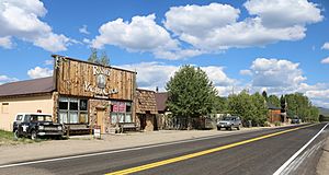
Buildings along Highway 125 in Rand.
|
|
| Country | |
| State | |
| County | Jackson |
| Established | 1881 |
| Elevation | 8,629 ft (2,630 m) |
| Time zone | UTC-7 (MST) |
| • Summer (DST) | UTC-6 (MDT) |
| ZIP code |
80473
|
| Area code(s) | 970 |
| GNIS feature ID | 172876 |
Rand is a small, quiet community in Jackson County, Colorado. It's not a big city with its own mayor, but a place where people live and work. It was first settled in 1881. You can find it in the United States, and it even has its own U.S. Post Office.
Contents
About Rand, Colorado
Rand is a community where many people work in ranching. It's located at the southern end of a large valley called North Park. This area is south of a town called Walden. In Rand, you'll see several homes, a few businesses, the post office, and buildings used for ranching.
Where is Rand Located?
Rand is found near where two roads meet: State Highway 125 and Jackson County Road 27. It sits along a stream called Indian Creek. The community is quite high up, at an elevation of about 8,627 feet (2,629 meters) above sea level. This is higher than many mountains in other parts of the world!
Rand's Post Office and ZIP Code
The post office in Rand is an important part of the community. It was officially opened in 1883. If you wanted to send mail to Rand, you would use the ZIP code 80473.
How Rand Got Its Name
There are a couple of ideas about how Rand got its name. Some people believe it was named after an early settler, Charles Rand. Others think it was named after another pioneer, J. A. Rand. It's a bit of a mystery!
 | Jackie Robinson |
 | Jack Johnson |
 | Althea Gibson |
 | Arthur Ashe |
 | Muhammad Ali |


