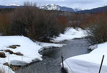
Michigan River facts for kids
Quick facts for kids Michigan River |
|
|---|---|

The Michigan River from SH 14 near Gould
|
|
| Physical characteristics | |
| Main source | Michigan Lakes 11,208 ft (3,416 m) 40°29′03″N 105°52′45″W / 40.48417°N 105.87917°W |
| River mouth | Confluence with North Platte 7,864 ft (2,397 m) 40°52′37″N 106°20′22″W / 40.87694°N 106.33944°W |
| Length | 69 mi (111 km) |
| Basin features | |
| Progression | North Platte—Platte— Missouri—Mississippi |
The Michigan River is a cool river in north central Colorado, United States. It's about 69 miles (111 km) long. This river flows into the North Platte River, which means it's a "tributary" – like a smaller stream feeding into a bigger one. It helps drain a part of eastern North Park in Jackson County.
Where the Michigan River Begins
The Michigan River begins high up in the mountains at Michigan Lakes. These are a group of lakes located at 11,208 feet (3,416 meters) above sea level! This spot is along the continental divide. The continental divide is like a giant mountain ridge. It separates which way water flows across a continent. Water on one side flows to the Pacific Ocean, and water on the other side flows to the Atlantic Ocean.
The River's Journey Downstream
From the lakes, the Michigan River flows north, then west. It passes the south end of Cameron Pass. The river then follows the path of State Highway 14. It flows past a small town called Gould.
After Gould, the river continues northwest. It goes through the ranch country of North Park. Here, the river often spreads out into many smaller streams. This creates a wide river bottom. It passes just east of Walden.
Where the River Meets Other Rivers
Just north of Walden, the Michigan River gets bigger. It receives water from the Illinois River. The Illinois River flows into it from the south. Finally, the Michigan River joins the North Platte River. This meeting point is about 5 miles (8 km) north of where the Illinois River joins.
 | Misty Copeland |
 | Raven Wilkinson |
 | Debra Austin |
 | Aesha Ash |

