Clark Peak (Medicine Bow Mountains) facts for kids
Quick facts for kids Clark Peak |
|
|---|---|

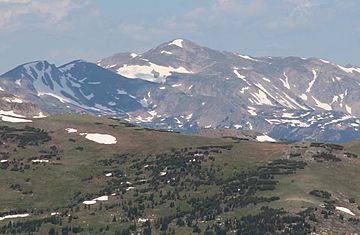
Clark Peak viewed from Rocky Mountain National Park
|
|
| Highest point | |
| Elevation | 12,960 ft (3,950 m) |
| Prominence | 2,771 ft (845 m) |
| Isolation | 16.40 mi (26.39 km) |
| Listing | Colorado county high points 33rd |
| Geography | |
| Location | Larimer County and the high point of Jackson County, Colorado, United States |
| Parent range | Highest summit of the Medicine Bow Mountains |
| Topo map | USGS 7.5' topographic map Clark Peak, Colorado |
Clark Peak is a very tall mountain located in the state of Colorado, United States. It stands as the highest point in the Medicine Bow Mountains, which are a part of the much larger Rocky Mountains in North America.
This impressive peak reaches an elevation of 12,960 feet (about 3,950 meters). It is found within the Rawah Wilderness area of the Routt National Forest. Clark Peak is about 10.1 kilometers (or 6.3 miles) north-northwest of Cameron Pass in Colorado.
The mountain sits right on the border between two counties: Jackson County and Larimer County. Clark Peak is actually the highest point in Jackson County. It is also the highest point in the entire area where water flows into the North Platte River. This area is called a drainage basin.
About Clark Peak
Clark Peak is known for its significant height and its important location. It's a "prominent" peak, which means it stands out clearly from the land around it. This makes it a notable landmark in the region.
Location and Features
Clark Peak is part of the Medicine Bow Mountains, a range that stretches across parts of Colorado and Wyoming. The mountain's position on the county line means it serves as a natural boundary. Its location in the Rawah Wilderness helps protect its natural beauty.
The mountain is also part of the drainage divide between Jackson and Larimer counties. A drainage divide is like a high ridge of land. It separates areas where water flows in different directions. For Clark Peak, water on one side flows towards Jackson County, and water on the other side flows towards Larimer County.
Geological Importance
As part of the Rocky Mountains, Clark Peak was formed over millions of years. This happened through powerful geological processes. These processes include the movement of Earth's plates. They also involve erosion by wind, water, and ice. The rocks that make up Clark Peak tell a long story of Earth's history.
The peak is a popular spot for experienced hikers and climbers. They enjoy the challenge and the amazing views from the summit. From the top, you can see vast stretches of the Rocky Mountains. You can also see the forests and wilderness areas below.
 | Toni Morrison |
 | Barack Obama |
 | Martin Luther King Jr. |
 | Ralph Bunche |


