Medicine Bow Peak facts for kids
Quick facts for kids Medicine Bow Peak |
|
|---|---|

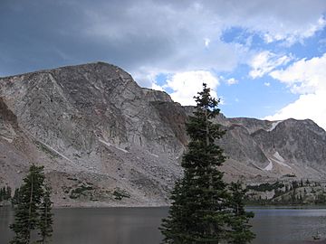
Southern extent of Medicine Bow Peak rising above Lake Marie.
|
|
| Highest point | |
| Elevation | 12,018 ft (3,663 m) |
| Prominence | 3233 |
| Geography | |
| Location | Albany and Carbon counties, Wyoming, U.S. |
| Parent range | Medicine Bow Mountains |
| Topo map | USGS Medicine Bow Peak (WY) |
| Geology | |
| Mountain type | quartzite |
| Climbing | |
| Easiest route | Hike |
Medicine Bow Peak is the tallest mountain in the Snowy Range, located in Wyoming, USA. It reaches a height of 12,018 feet (3,663 meters). This makes it the highest point in southern Wyoming. The peak is about 35 miles west of Laramie, Wyoming.
Most of Medicine Bow Peak is in Albany County. Its lower parts stretch into Carbon County. You can easily see the summit from Snowy Range Pass on Wyoming Highway 130. This road is a scenic byway, offering great views.
Many people enjoy hiking to the top of Medicine Bow Peak. The most common trail is about four miles long. It has switchbacks and some loose rocks. These trails are usually open from early June to mid-October. The mountain is often covered in snow from October until late June. In winter, people can reach the peak by snowshoeing or skiing. Summer weather can be tough, with thunderstorms and hail often happening in the afternoons.
Contents
How Medicine Bow Peak Was Formed
Medicine Bow Peak is part of a very old rock ridge. This ridge is made of a hard rock called quartzite. The mountain was shaped by glaciers a long time ago. Even today, you can find snowfields on its sides all year round.
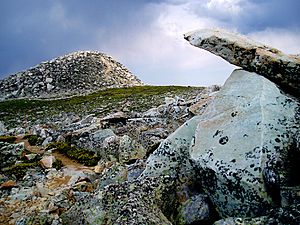
Above the tree line, you might see interesting patterns on the ground. These are called "stone nets" or "periglacial polygons." They are formed by the freezing and thawing of the ground. Several glacial lakes are also found at the bottom of the peak. These lakes were created by the glaciers.
Scientists believe the rocks at Medicine Bow Peak are much older than the surrounding Medicine Bow Mountains. They sometimes call the mountain "Medicine Peak" and its rock "Precambrian Medicine Peak Quartzite." This quartzite sits on even older basement rock. Scientists have looked for signs of ancient life in these rocks. However, the findings might just be natural rock formations, not actual fossils.
History of Medicine Bow Peak
Not much is known about Medicine Bow Peak's early history. This changed after the John C. Frémont expeditions in the 1830s. Before that, Native American tribes lived in the nearby lowlands. Tribes like the Northern Arapaho, Northern Cheyenne, Lakota, Ute, and Eastern Shoshone used the mountain passes for travel.
In 1955, a plane called United Airlines Flight 409 had an accident on the side of the mountain. Parts of the plane can still be seen at the base of the cliff. During the recovery efforts, new paths were made to reach the area. These paths are still used today.
A special memorial stone and plaque were placed near the site in August 2001. This area is sometimes called "Disaster Wall." It serves as a reminder of the event.
Plants and Animals of Medicine Bow Peak
The trails leading to Medicine Bow Peak pass through different types of natural areas. These include alpine meadows, sub-alpine meadows, and taiga forests. You can see small, twisted trees called Krummholtz near the tree line. Many of these are Engelmann spruce trees.
Many beautiful wildflowers grow along the trails. These include Indian paintbrush, blue columbine, gentian, and harebell. The peak is part of a special area known for its unique plants.
Many animals live on and around Medicine Bow Peak. You might spot bighorn sheep climbing the rocky slopes. Other mammals include marmots, pikas, pine martens, mule deer, and tiny dwarf shrews.
Maps
 | George Robert Carruthers |
 | Patricia Bath |
 | Jan Ernst Matzeliger |
 | Alexander Miles |


