Sweetwater River (Wyoming) facts for kids
Quick facts for kids Sweetwater River |
|
|---|---|

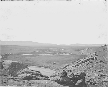
1870 photograph of the Sweetwater River.
|
|

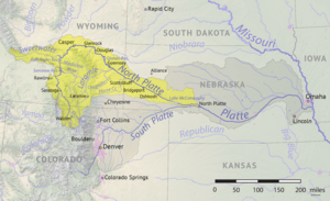
North Platte, Sweetwater Rivers across Wyoming
|
|
| Country | United States |
| State | Wyoming |
| Cities | Sweetwater Station, Jeffrey City |
| Physical characteristics | |
| Main source | Sweetwater Gap Wind River Range, Fremont County 10,200 ft (3,100 m) 42°39′15″N 109°03′25″W / 42.65417°N 109.05694°W |
| River mouth | North Platte River Pathfinder Reservoir, Natrona County 5,853 ft (1,784 m) 42°30′25″N 109°03′25″W / 42.50694°N 109.05694°W |
| Length | 238 mi (383 km) |
| Basin features | |
| Basin size | 2,880 sq mi (7,500 km2) |

The Sweetwater River is a 238-mile (383 km) long river in Wyoming, a state in the United States. It flows into the North Platte River. The North Platte River is part of the larger Mississippi River system. This means the water from the Sweetwater River eventually travels all the way to the Gulf of Mexico.
Contents
River's Journey: Where Sweetwater Flows
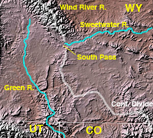
The Sweetwater River begins in the southwestern part of Fremont County. It starts near South Pass, which is a low point on the Continental Divide. The Continental Divide is like a big ridge that separates rivers flowing to the Atlantic Ocean from rivers flowing to the Pacific Ocean. The river's source is on the southern side of the Wind River Range mountains.
The river flows east-northeast, past the Antelope Hills. Then it turns southeast, moving through Fremont County. It passes by the town of Jeffrey City. The river flows between the Granite Mountains to the north and the Green Mountains to the south. This area is mostly used for raising cattle today.
In southern Natrona County, the Sweetwater River passes two famous landmarks: Devil's Gate and Independence Rock. These places were very important for pioneers traveling on the Oregon, California, and Mormon Trails. Finally, the Sweetwater River flows into the North Platte River. It forms an arm of the Pathfinder Reservoir.
Sweetwater's Past: A Historic Pathway
The valley of the Sweetwater River was a very important route for early travelers. It was used by fur trappers and mountain men in the early 1800s. These adventurers traveled to their yearly meetings, called Rocky Mountain Rendezvous, often held along the Green River in Wyoming. The trappers and traders soon made a path for their pack animals along the Sweetwater. Over time, this path became a rough wagon trail leading to the Green River.
Early Explorers and the River
In the fall of 1823, two famous trappers, Jedediah Smith and Thomas Fitzpatrick, led their group south from the Yellowstone River. They were looking for a safe place to spend the winter. Smith thought that since the Sweetwater River flowed east, it must eventually connect to the Missouri River.
They tried to float their valuable collection of furs down the Sweetwater and North Platte Rivers. But after a dangerous canoe accident, they realized the rivers in Wyoming were too fast and rough for boats. So, on July 4, 1824, they hid their furs under a large rock formation. They named this spot Independence Rock. Then, they began a long walk to the Missouri River. They followed the Sweetwater, North Platte, and Platte River valleys.
When they reached a settled area on the Missouri River, they bought horses. They returned to get their furs. They had rediscovered a route that Robert Stuart had taken 11 years earlier in 1813. Thomas Fitzpatrick later became a guide for many groups. Jedediah Smith was killed by Native Americans around 1831.
The Sweetwater and Pioneer Trails
By 1843, the Sweetwater River valley was a regular wagon trail. It provided the water, grass, and wood that pioneers needed on their journey across Wyoming. The Sweetwater offered a nearly direct path from the Platte and North Platte Rivers to the wide South Pass. South Pass was the easiest way to cross the Continental Divide between the Atlantic and Pacific Ocean river systems.
Pioneer wagons usually crossed the winding Sweetwater River about nine times. Their journey along the Sweetwater River took about 10 to 20 days before they reached South Pass. The Sweetwater River's connection to the California Trail is special for members of the Phi Gamma Delta fraternity. Two early members met there by chance, which was very rare at that time. This meeting was so lucky that it became part of the fraternity's history.
See also
 In Spanish: Río Sweetwater para niños
 | Jackie Robinson |
 | Jack Johnson |
 | Althea Gibson |
 | Arthur Ashe |
 | Muhammad Ali |

