
Sweetwater River (California) facts for kids
Quick facts for kids Sweetwater River |
|
|---|---|

The river's upper reaches near State Route 79
|
|

Map of the river basin
|
|
| Other name(s) | Agua Dulce |
| Country | United States |
| State | California |
| Region | San Diego County |
| Cities | Descanso, La Presa, Bonita, National City, Chula Vista |
| Physical characteristics | |
| Main source | Upper Green Valley Cuyamaca Mountains 4,809 ft (1,466 m) 32°59′03″N 116°32′04″W / 32.98417°N 116.53444°W |
| River mouth | Sweetwater Marsh Between National City and Chula Vista 13 ft (4.0 m) 32°38′34″N 117°06′53″W / 32.64278°N 117.11472°W |
| Length | 55 mi (89 km) |
| Basin features | |
| Basin size | 230 sq mi (600 km2) |
| Tributaries |
|
The Sweetwater River is a 55-mile (89 km) long stream in San Diego County, California. It starts high in the Cuyamaca Mountains. The river then flows southwest through wild areas. Later, it enters busy cities before reaching San Diego Bay.
The river's water is known for tasting good. This is why it's called "Sweetwater." The Spanish explorers called it "Agua Dulce," which also means "sweet water." This name was given to any clear, good-tasting water they found.
Contents
Journey of the Sweetwater River
The Sweetwater River begins as a small stream in Upper Green Valley. This area is deep in the Cuyamaca Mountains. It flows south and southwest. Along the way, it gets water from smaller streams like Harper Creek and Stonewall Creek. It then passes through the small town of Descanso.
River's Path Through Dams
As the river enters the Cleveland National Forest, it goes through a rocky gorge. It also flows under a tall bridge of Interstate 8. Soon after leaving the forest, the river reaches Loveland Reservoir. This lake is formed by Loveland Dam, one of two main dams on the Sweetwater.
The river continues west past Rancho San Diego. It then flows into Sweetwater Reservoir. This larger lake is created by the Sweetwater Dam. Below this dam, the river flows through Sweetwater Regional Park. It passes the city of Bonita.
Reaching San Diego Bay
The river then turns northwest. It enters a special channel built to control floods. It flows between National City and Chula Vista. The part of the river affected by ocean tides is called the Sweetwater Marsh. The river finally empties into San Diego Bay. This is about 7.5 miles (12.1 km) southeast of downtown San Diego.
Sweetwater River's Drainage Area

The Sweetwater River drains a long, narrow area of about 230 square miles (600 km2). This area is in southern California. The river's mouth is less than 20 miles (32 km) north of the U.S.-Mexico border. Much of this area is mountainous. The highest point is Stonewall Peak, which is 5,730 feet (1,746 m) high. A large part of the river's drainage area is within the Cleveland National Forest. The Sweetwater is the biggest river flowing into San Diego Bay.
Most of the land, about 64 percent, is wilderness or parks. However, about 30% is developed with cities and towns. Native American reservations also use some of the land. Over 300,000 people live in this area. Most live in cities like Chula Vista, National City, La Presa, Bonita, and Rancho San Diego. These cities are in the flatter western part of the river basin.
The eastern edge of the Sweetwater's drainage area is in the Cuyamaca Mountains. This ridge separates rivers flowing to the Pacific Ocean from those flowing to the Salton Sea. To the north, the Sweetwater basin is next to the San Diego River basin. To the south, it borders the Otay River and Tijuana River areas.
Before reaching San Diego Bay, the river flows into the 316-acre (1.28 km2) Sweetwater Marsh. This marsh is part of the San Diego National Wildlife Refuge. Next to the marsh is the Chula Vista Nature Center. It offers nature walks and has an aviary with local birds.
History of the Sweetwater River
Long ago, the Sweetwater River was a small stream that flowed all year. Its banks were covered with forests and marshes. People are thought to have arrived in the San Diego Bay area thousands of years ago. The Kumeyaay people called this river "Ah-ha-ooo-mulk," meaning "water sweet." They had villages along the river.
The first European to visit was Juan Rodríguez Cabrillo in 1542. His visit helped Spain claim the area. Spanish settlers arrived in the 1760s. They called the river "Agua Dulce." Later, the land became part of large ranches.
After California became part of the United States, many new settlers arrived. They built farms along the Sweetwater River. The Sweetwater Dam was built in 1888. It helped store water for farms and towns. By the late 1800s, much of the river's water was used for irrigation. This meant less water flowed freely in the river.
Dams on the Sweetwater River

The Sweetwater River has three dams along its path.
- Palo Verde Dam: This is a small dam near Alpine. It is used for fun activities and to help control floods.
- Loveland Dam: This is a much larger dam. It creates Loveland Reservoir.
- Sweetwater Dam: This is the last and largest dam. It forms Sweetwater Reservoir. This lake is about 8 miles (13 km) from the river's mouth.
The Sweetwater Authority operates Loveland and Sweetwater Dams. Loveland Dam mainly helps with flood control. Sweetwater Dam stores water for cities like San Diego, National City, and Chula Vista. It also receives water from the San Diego Aqueduct.
Animals and Plants of the Sweetwater River
The Sweetwater River area is home to many interesting animals and plants.
- Western Pond Turtle: This endangered turtle has been found in a stream that flows into the Sweetwater River. This was an exciting discovery for wildlife experts.
- Endangered Birds: The nearby San Diego National Wildlife Refuge protects birds like the least Bell’s vireo and California gnatcatcher.
- Rare Butterfly: The rare Quino checkerspot butterfly also lives here.
Beaver in the Sweetwater Area
It was once debated if beavers lived in San Diego County. However, a report from 1866 mentioned beavers in the area. There is also a creek called Beaver Hollow that flows into the Sweetwater River. This creek was named on a map in 1903. This was before beavers were brought back to California by wildlife groups. This suggests beavers were naturally present here.
Fish in the River
The upper parts of the Sweetwater River have wild rainbow trout. These fish can be found in several small streams that feed the river. These include Cold Springs Creek, Harper Creek, and Stonewall Creek.
Fun Activities at Sweetwater River
There are many ways to enjoy the Sweetwater River area.
- Sweetwater County Park and Regional Park: These parks are located near Sweetwater Reservoir. They have trails for hiking, biking, and horseback riding. You can see palm trees, cottonwoods, and eucalyptus trees. You might also spot desert barrel and teddy-bear cholla cacti.
- Sweetwater Marsh National Wildlife Refuge: This refuge is closer to the ocean.
- Chula Vista Nature Center: Inside the refuge, this center is great for kids. It has tanks with animals and outdoor areas with injured birds.
- Exploring the Refuge: You can take a bus to the refuge entrance. Inside, there are well-kept trails leading to the bay. You might see birds like great egrets, ospreys, and mallards.
Rivers and Streams Joining the Sweetwater
Many smaller rivers and streams flow into the Sweetwater River. Here are some of them:
- Rice Canyon
- Long Canyon
- Spring Creek (San Diego County)
- Dehesa Creek
- Harbison Canyon
- North Fork Sweetwater River
- Beaver Hollow Creek
- Lawson Creek (San Diego)
- Taylor Creek (California)
- Viejas Creek
- Samagatuma Creek
- Descanso Creek
- Juaquapin Creek
- Japacho Creek
- Cold Stream (San Diego)
- Harper Creek
- Stonewall Creek
Images for kids
-
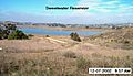
Sweetwater Reservoir
-
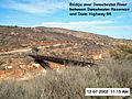
Bridge upstream from Sweetwater Reservoir
-
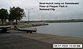
Boat launch ramp near mouth
-
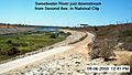
Near Second Ave. in National City
-
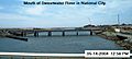
Mouth of river
-
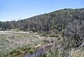
Near State Highway 79
-
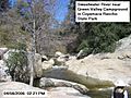
Near Green Valley Campground
-
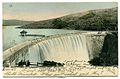
Sweetwater Dam, about 1907


