Cuyamaca Mountains facts for kids
Quick facts for kids Cuyamaca Mountains |
|
|---|---|
| Highest point | |
| Peak | Cuyamaca Peak |
| Elevation | 1,985 m (6,512 ft) |
| Geography | |
| Country | United States |
| State | California |
| District | San Diego County |
| Range coordinates | 32°56′31.174″N 116°36′14.070″W / 32.94199278°N 116.60390833°W |
| Topo map | USGS Cuyamaca Peak |
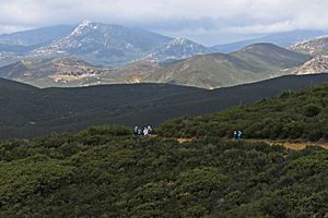
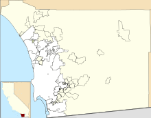
The Cuyamaca Mountains, also known as the Cuyamacas, are a mountain range in San Diego County, southern California. They are part of the larger Peninsular Ranges System. These mountains stretch from the northwest to the southeast. The Laguna Mountains are right next to them on the east.
Most of the Cuyamaca Mountains are covered in thick oak forests and chaparral, which is a type of shrubland. You can also find pine forests and green areas with year-round creeks and waterfalls. The San Diego River and Sweetwater River both start in these mountains. These rivers flow for over 50 miles to the ocean. In 2003, a big wildfire called the Cedar Fire burned many pine forests and large areas of chaparral and oak woodlands. Since then, the plants have been slowly growing back.
Because the mountains are high up, they get snow during the winter months. Cuyamaca Peak is the second highest point in San Diego County, standing at about 6,512 feet (1,985 meters) tall. Only Hot Springs Mountain is taller.
Exploring the Cuyamaca Mountains
The highest points in the Cuyamaca Mountains include Cuyamaca Peak at 6,512 feet (1,985 meters), North Peak at 5,993 feet (1,827 meters), Middle Peak at 5,883 feet (1,793 meters), and Stonewall Peak at 5,700 feet (1,737 meters). Both the San Diego River and the Sweetwater River begin their journey in these mountains. The Cuyamaca Reservoir is located next to the eastern side of the range.
Much of the mountains are protected within the Cleveland National Forest. Cuyamaca Rancho State Park is also found here, known for its beautiful California oak woodlands.
The historic mining town of Julian is in the northern part of the mountains. Other towns like Descanso, Pine Valley, and Guatay are in the southern area. Alpine, a larger town, is just west of the range.
Interstate 8 goes through the southern part of the Cuyamaca Mountains. California State Route 79, also called the Cuyamaca Highway, runs north and south along the eastern side of the mountains.
A Rush for Gold

In 1870, gold was found in the Cuyamaca Mountains, leading to a "gold rush." Many towns and camps quickly appeared to support the miners. These included Coleman City, Branson City, Eastwood, Julian, and Banner.
One important mining area was first called Stonewall (from 1873 to 1876). Later, it became a company town called Stratton (1887–1888), then renamed Cuyamaca City (1888–1906). At its busiest, about 500 people lived there, working at the Stonewall Mine. The town was left empty after the mining stopped, and today, very little of it remains. The site is now part of Cuyamaca Rancho State Park.
The town of Julian also supported many gold mines. Julian still celebrates its mining past with an annual event called Gold Rush Days. The Eagle-High Peak Mine, which no longer produces gold, is now a museum. You can take daily tours there to learn about the history of gold mining.
Fun Things to Do
The Cuyamaca Mountains offer many fun activities. At Lake Cuyamaca, you can find camping spots for tents and areas for motorhomes. The lake is also great for fishing and boating.
There are many trails throughout the mountains for hiking, biking, and horseback riding. The town of Julian is at the north end of the range. It hosts various events and shares its 19th-century history. Near Julian, you can visit the California Wolf Center. This center works to protect wolves, educate people, and conduct research to help wolves in the wild.
 | Audre Lorde |
 | John Berry Meachum |
 | Ferdinand Lee Barnett |


