
Cuyamaca Peak facts for kids
Quick facts for kids Cuyamaca Peak |
|
|---|---|

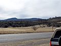
Cuyamaca Peak from the South
|
|
| Highest point | |
| Elevation | 6,515 ft (1,986 m) NAVD 88 |
| Prominence | 2,855 ft (870 m) |
| Listing | Hundred Peaks Section |
| Geography | |
| Location | San Diego County, California, U.S. |
| Parent range | Cuyamaca Mountains |
| Topo map | USGS Cuyamaca Peak |
| Climbing | |
| Easiest route | Hike, class 1 |
Cuyamaca Peak is a tall mountain in the Cuyamaca Mountains range. You can find it in San Diego County, which is in Southern California. It's a popular spot for hikers and nature lovers.
Contents
Exploring Cuyamaca Peak: A Tall Mountain in San Diego
Cuyamaca Peak is the second highest point in San Diego County. Its top reaches about 6,512 feet (1,985 m) into the sky. That's pretty high!
This mountain is located inside Cuyamaca Rancho State Park. It's about 40 miles (64 km) away from the Pacific Ocean. The peak is east of the city of San Diego. It's also southwest of a small town called Julian.
Many people enjoy hiking to the top of Cuyamaca Peak. There's a popular trail that is about 3.5-mile (5.6 km) long. The hike starts at the Paso Picacho Campground. This campground is already at about 5,000 feet (1,500 m) elevation. You can hike this trail all year round.
Nature and Wildlife on Cuyamaca Peak
The area around Cuyamaca Peak gets snow in winter. Snow is common above 5,000 feet (1,500 m) in Cuyamaca Rancho State Park. In the summer, the mountain meadows are full of plants. You can see Bracken Ferns and many kinds of wildflowers. Native bunchgrasses also grow on the forest floor. Before a big fire, Black oaks used to light up the mountain with their colors.
The Cedar Fire's Impact on the Forest
In October 2003, a huge fire happened. It was called the Cedar Fire. This fire was the largest in California's recorded history. It burned many trees that once covered the mountain. These trees included White Firs, Incense Cedars, Jeffrey Pines, Coulter Pines, Sugar Pines, and Black oaks.
But nature is amazing at recovering! Within a year of the Cedar Fire, small seedlings started to grow. These were new White fir, Sugar Pine, Coulter Pine, Jeffrey Pine, and Incense Cedar trees. By 2007, they were growing well as young trees. This shows how nature can heal itself, which is part of fire ecology.
Weather and Rain on the Mountain
Cuyamaca Peak is very tall compared to the land around it. This means it easily catches moisture from the Pacific Ocean. Clouds form and are forced to release their moisture as rain or snow. The mountain gets between 20 and 32 inches of rain each year.
Most of this rain, about 70%, falls during fall and winter storms. Summer thunderstorms bring the rest of the moisture. In winter, snow can fall on the peak. You might also see hoar frost on the highest parts of the mountain.
Amazing Views from the Summit

On a clear day, the views from the top of Cuyamaca Peak are incredible. You can see for 60–100 miles (97–161 km) in almost every direction.
Looking west, you can see the Pacific Ocean. You might even spot the Coronado Islands of Mexico. The coastline of San Diego County is also visible. You can also see Viejas Mountain and El Cajon Mountain.
To the north, you can see Palomar Mountain, which is about 6,140-foot (1,870 m) tall. On very clear days, you might see even taller peaks. These include 8,716-foot (2,657 m) Toro Peak in the Santa Rosas. The San Jacintos are also sometimes visible. Closer to the northeast is Volcan Mountain. The old gold rush town of Julian lies in front of it. Directly north are Middle and North Peaks, which are the closest summits.
To the east, you can see the Anza Borrego Desert. The Laguna Mountains, including Whale Peak, are also there. Far beyond, you can spot the Salton Sea. To the south, you'll see Lyons Peak and Lawson Peak. Further south and to the southeast are Mexican border mountains. These include Table Top Mountain and the Sierra de Juárez.
Images for kids
-
View of Cuyamaca Peak from the east.
-
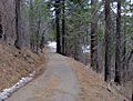
Just down from the Cuyamaca summit.
-
Burned forest on the lower slopes of Cuyamaca.
-
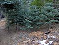
Forest nearing the summit.
-
White Firs near Cuyamaca's summit, with deceased Bracken Ferns.
-
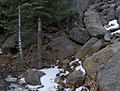
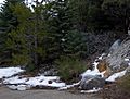
A typical scene on Cuyamaca: White Firs, Granite rocks, and January snow.
-
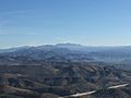
View of Cuyamaca Peak from North Fortuna Mountain in San Diego.
-
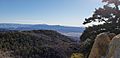
Cuyamaca Peak from Hot Springs Mountain


See also
 In Spanish: Pico Cuyamaca para niños
