Otay River facts for kids
Quick facts for kids Otay River |
|
|---|---|

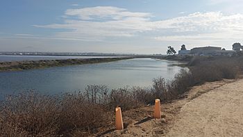
The river as it flows at the northern extreme of Imperial Beach, California
|
|
| Country | United States |
| State | California |
| Region | San Diego County |
| Physical characteristics | |
| Main source | Outlet of Lower Otay Reservoir Otay County Open Space Preserve 392 ft (119 m) 32°36′39″N 117°06′59″W / 32.61083°N 117.11639°W |
| River mouth | San Diego Bay Imperial Beach 0 ft (0 m) 32°36′23″N 116°55′29″W / 32.60639°N 116.92472°W |
| Length | 25 mi (40 km) |
| Basin features | |
| Basin size | 160 sq mi (410 km2) |
| Tributaries |
|
The Otay River is a river located in the southern part of San Diego County, California. This river is about 25 miles (40 kilometers) long. It starts near San Miguel Mountain and flows through two important reservoirs, the Upper and Lower Otay Reservoirs. The river then continues its journey between the city of Chula Vista and the Otay Mesa West area of San Diego. Finally, it reaches its end, or river mouth, at San Diego Bay.
Contents
About the Otay River
The Otay River is part of a large area of land called a watershed. A watershed is all the land where water drains into a specific river or body of water. The Otay River's watershed covers about 160 square miles (414 square kilometers).
The River's Surroundings
To the north of the Otay River's watershed is the watershed of the Sweetwater River. To the south, you'll find the watershed of the Tijuana River.
Between two major highways, Interstate 5 and Interstate 805, is the Otay Valley Regional Park. This park is a great place for outdoor activities and enjoying nature. As of 2016, there were plans to bring back a natural marshy area, called an estuary, that existed along the river before the time of Mexican rule in California. This area is currently used by the South Bay Salt Works.
Otay River Reservoirs
The Otay River is very important because it helps supply drinking water to parts of southern San Diego County. It does this through two main reservoirs.
Lower Otay Reservoir
The Lower Otay Reservoir was created by the Savage Dam, which was finished in 1921. This reservoir is quite large and can hold a lot of water, about 49,510 acre-feet. This water is used to provide drinking water to nearby communities. The reservoir is also where Pipeline 3 of the Second San Diego Aqueduct ends. This pipeline brings water all the way from the Colorado River using the Colorado River Aqueduct.
A Dam's History
Before the Savage Dam, there was an older dam called the Lower Otay Dam. It was built in 1897 but unfortunately broke in 1916 after very heavy rains.
Upper Otay Reservoir
The Upper Otay Reservoir was formed by the Upper Otay Dam, which was built in 1901. This reservoir has a special history with fish.
Fish and Fishing
In 1959, the Upper Otay Reservoir became a special place, like a "hatchery," for introducing a type of fish called Florida-strain largemouth bass. To prepare the reservoir for these new fish, it was cleaned out first to make sure only the new fish would thrive. In 1996, the reservoir was opened for fishing. However, there's a rule: all fish caught must be released back into the water. This is called "catch and release" fishing.
Why No Swimming?
Since the water in both the Lower and Upper Otay Reservoirs is used for drinking water, people are not allowed to swim or have direct contact with the water. This helps keep the water clean and safe for everyone to drink.
A Bit of History
Early Flight Tests
Did you know that the Otay River area played a small part in the history of flight? In the late 1800s, a famous aviator named John J. Montgomery conducted some of his early tests of manned gliders in this region. He was one of the pioneers of aviation!
 | Selma Burke |
 | Pauline Powell Burns |
 | Frederick J. Brown |
 | Robert Blackburn |

