
Wind River Range facts for kids
Quick facts for kids Wind River Range |
|
|---|---|

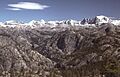
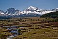
Wind River Range highcountry
|
|
| Highest point | |
| Peak | Gannett Peak |
| Elevation | 13,804 ft (4,207 m) |
| Dimensions | |
| Length | 100 mi (160 km) NW/SE |
| Width | 30 mi (48 km) SW/NE |
| Area | 2,800 sq mi (7,300 km2) |
| Geography | |

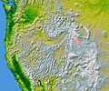
The Wind River Range highlighted in pink
|
|
| Country | United States |
| State | Wyoming |
| Parent range | Rocky Mountains |


The Wind River Range, often called the "Winds," is a large mountain range in the Rocky Mountains. It is located in western Wyoming in the United States. This range stretches about 160 kilometers (100 miles) from northwest to southeast.
The Continental Divide runs along the top of the Wind River Range. This means that rivers on one side flow to the Pacific Ocean, and rivers on the other side flow to the Atlantic Ocean. The range is home to Gannett Peak, which is Wyoming's highest mountain at 4,207 meters (13,804 feet). Fremont Peak, the state's third highest peak, is also here. More than 40 other peaks in the Winds are over 3,962 meters (13,000 feet) tall.
Most of the Wind River Range is protected by two large national forests. These are the Shoshone National Forest on the east and the Bridger-Teton National Forest on the west. These forests are part of the bigger Greater Yellowstone Ecosystem. Some parts of the eastern side of the range are also within the Wind River Indian Reservation.
Contents
History of the Wind River Range
Indigenous peoples of the Great Basin, like the Shoshone and Absaroka (Crow) tribes, lived in the Wind River Range thousands of years ago. They were here between 7,000 and 9,000 years ago. Archaeologists have found ancient villages high up in the mountains. Some of these villages, dating from 700 to 2000 BC, were used by the Sheepeater Shoshone. They came to these villages to gather pine nuts. One village, called "High Rise," has 60 lodges and covers 26 acres. It is now on the National Register of Historic Places.
Early Explorers and Settlers
John Colter, a member of the Lewis and Clark Expedition, might have been the first European American to see the range around 1807. However, not much is known about his exact travels there. In 1812, a group led by Wilson Price Hunt was the first to cross South Pass. This pass is at the southern end of the range and marks the Continental Divide. It later became a very important part of the Oregon Trail.
Mountain Climbing Adventures
People started climbing in the Wind River Range in the mid-1800s. Early climbers like John C. Frémont often climbed to survey the land. Later, in the 1920s, people began climbing just for fun. Gannett Peak was first climbed in 1922 by Arthur Tate and Floyd Stahlnaker. Many early climbs happened around the Titcomb Basin. Today, the Titcomb Basin and the Cirque of the Towers are still very popular for climbers and hikers.
Protecting the Wilderness
Much of the Wind River Range became federally protected in the 1930s. Today, three wilderness areas protect most of the range. These are the Bridger Wilderness (created in 1964) on the west side, and the Fitzpatrick Wilderness (1976) and Popo Agie Wilderness (1984) on the east side. Together, these areas cover over 728,020 acres. This makes the Wind River Range one of the largest areas in the United States without roads.
Geology and Glaciers
The Wind River Range is mostly made of a type of rock called granite. This granite formed deep inside the Earth over a billion years ago. Over millions of years, the rocks above it wore away. As the land rose during the Laramide orogeny (a period of mountain building), more erosion happened. This left behind the granite rocks we see today.
The ice ages, which started about 500,000 years ago, shaped these rocks. Glaciers carved out many lakes and circular valleys called cirques. The Cirque of the Towers is a famous example of a cirque in the southern part of the range. The Shoshone National Forest has 156 glaciers on its eastern side. The Bridger-Teton National Forest has 27 more on the western slopes. Some of these are the largest glaciers in the U.S. Rocky Mountains. Gannett Glacier, on Gannett Peak, is the biggest single glacier in the U.S. Rockies.
Waterways and Lakes
Many important rivers start in the Wind River Range. The Green River and Big Sandy River flow south from the west side. The Wind River flows east into the Wind River Basin. The Green River is a main branch of the Colorado River. The Wind River later becomes the Bighorn River, which is a main branch of the Yellowstone River. The range also has deep canyons, like Silas Canyon and Sinks Canyon, on its eastern side.
The Bridger Wilderness alone has over 1,300 lakes. These lakes vary in size, from small ponds to large lakes over 200 acres. Historically, many of these alpine lakes did not have fish. Fish were first brought to the area in 1907. Between 1924 and 1935, many fish, like Colorado River cutthroat trout, were added to the lakes and streams.
Wildlife and Plants


The Wind River Range is home to many animals. A small population of grizzly bears lives here, mostly in the northern areas. Other mammals include black bears, moose, mule deer, pronghorn, bighorn sheep, mountain lions, and wolverines. Over 300 species of birds live in the region, including bald eagles, falcons, and hawks.
The streams and lakes are full of fish like Yellowstone cutthroat, rainbow, brook, brown, lake, and golden trout. During the Great Depression, a local explorer named Finis Mitchell and his wife stocked about 2.5 million fish here. The forests are mainly made up of lodgepole pine, whitebark pine, subalpine fir, and Engelmann spruce.
The Wind River Range is important for animal migration routes. It has several key passes. South Pass, at 2,301 meters (7,550 feet), is at the southern end. It was a vital pass on the Oregon Trail. No roads cross the mountains between South Pass and Union Pass, which is at the northern end of the range.
Recreation and Activities
The Winds are a very popular place for outdoor fun. The huge wilderness areas attract hikers, climbers, and skiers. Many backcountry areas are used a lot, even though they are remote. Two popular places for backpacking are the Titcomb Basin and the Cirque of the Towers.
The exposed granite rocks at higher elevations are great for climbing. Areas like the Cirque of the Towers are so popular that they are facing overuse issues. The Wind River Range also has one ski area, White Pine. It is the only place in the range with lift-accessible skiing and snowboarding. Located near Pinedale, it is the oldest ski area in Wyoming.
Popular Trails for Exploration
The Wind River Range has many trailheads for backpackers to explore. These include:
- Big Sandy (elevation 2,768 m or 9,080 ft)
- Boulder Lake (elevation 2,371 m or 7,780 ft)
- Burnt Lake (elevation 2,438 m or 8,000 ft)
- Elkhart Park (elevation 2,829 m or 9,280 ft)
- Green River Lake (elevation 2,450 m or 8,040 ft)
- Half Moon Lake (elevation 2,316 m or 7,600 ft)
- Meadow Lake (elevation 2,450 m or 8,040 ft)
- New Fork (elevation 2,405 m or 7,890 ft)
- Scab Creek (elevation 2,400 m or 7,870 ft)
- Spring Creek Park (elevation 2,585 m or 8,480 ft)
The Wind River Range is a favorite spot for outdoor enthusiasts. It also hosts many wilderness and outdoor education programs. Its many trails and varied terrain make it a perfect place for learning and adventure.
Safety in the Wilderness
When visiting the Wind River Range, it's important to be aware of potential dangers. Encountering bears is a concern, especially grizzly bears in the northern areas. Other things to watch out for include bugs, wildfires, difficult snow conditions, and very cold temperatures at night.
There have been serious incidents in the past, including unfortunate accidents from falls from steep cliffs and falling rocks. These incidents have occurred over the years, including in 1993, 2007, 2015, and 2018. It's crucial to be careful in this challenging terrain. In 2005, a seriously injured backpacker was airlifted near Squaretop Mountain. In 2006, a hiker died from an apparent accidental fall, leading to a state search and rescue effort. The United States Forest Service does not provide official records on the total number of fatalities in the Wind River Range.
Images for kids
-
Wind River Range highcountry
-
The Wind River Range highlighted in pink
-
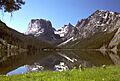
Green River Lakes and Squaretop Mountain
-
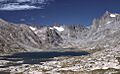
Titcomb Lakes
-
Looking across the Bonneville Basin to Mount Bonneville and Raid Peak.
-
Lake d'Amalia, late 19th century
-
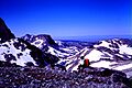
Wind River Range - looking southwest from near the top of Fremont Peak - during a backpacking trip.
See also
 In Spanish: Cordillera Wind River para niños
