
Union Pass facts for kids
Quick facts for kids Union Pass |
|
|---|---|
 |
|
| Elevation | 9,212 ft (2,808 m) |
| Traversed by | Prehistoric |
| Location | Fremont County, Wyoming, US |
| Range | Wind River Range |
| Coordinates | 43°28′53″N 109°52′36″W / 43.48139°N 109.87667°W |
| Topo map | USGS Fish Creek Park (WY) |
|
Union Pass
|
|
| Location | Wind River Range |
|---|---|
| Nearest city | Dubois, Wyoming |
| NRHP reference No. | 69000367 |
| Added to NRHP | April 4, 1969 |
Union Pass is a high mountain pass located in the Wind River Range in Fremont County, western Wyoming. A mountain pass is like a low spot or gap between mountains. It makes it easier to travel from one side to the other.
This pass sits on the Continental Divide. This is a line that separates which ocean water flows to. Water on one side goes to the Pacific Ocean. Water on the other side goes to the Atlantic Ocean.
Union Pass is special because it's near a "triple divide." This means water from this spot can flow to three different major river systems: the Mississippi River, the Columbia River, or the Colorado River.
Native Americans used this pass for a very long time. Later, early American explorers and fur traders, called mountain men, also used it. The Astor Expedition crossed it in 1811. On their way back, they found another important pass, South Pass.
U.S. Army Captain William F. Raynolds named Union Pass in 1860. He was exploring the Yellowstone area. A famous mountain man named Jim Bridger guided his group over the pass.
Location of Union Pass
Union Pass is found in the mountains of northwestern Wyoming. It is about 9,210 feet (2,807 meters) high. Think of it as a central point where three Wyoming mountain ranges meet.
These ranges spread out in different directions. The Wind River Range goes southeast. Its highest point is Gannett Peak, at 13,804 feet (4,207 meters). The Gros Ventre Range is to the west. Its highest point is Doubletop Peak, at 11,720 feet (3,572 meters). The Absaroka Range is to the north. Its highest point is Francs Peak, at 13,153 feet (4,009 meters).
Union Pass is about 4,000 feet (1,219 meters) lower than the mountains around it. This makes it a good pathway. It connects the beginnings of three big river systems: the Colorado River, the Columbia River, and the Missouri River.
Today, a dirt road crosses the pass. This road connects U.S. Route 287 near Dubois to U.S. Route 189 in Pinedale.
Native American History
Long before European explorers arrived, Native American tribes used Union Pass. Fur trappers who first explored these mountains heard about these trails. Tribes like the Shoshone, Bannack, Arapaho, Gros Ventre, Bitterroot Salish, Nez Perce, and Crow used the pass.
The pass gave them access to three major river areas. An east-west route went up the Wind River valley. From there, travelers could go west along the Gros Ventre or Hoback Rivers. This led them to the Snake River valley in Jackson's Hole.
To go south, people would follow the Green River. The Union Pass route was also part of a north-south trail. This trail went up the Valley of the Yellowstone. It passed west of the Absaroka Mountains and south of Yellowstone Lake.
Travelers would follow the North Fork of the Yellowstone. After crossing Two Ocean Pass, the trail split. It went east and west around Terrace Mountain into the Wind River Valley. From Union Pass, travelers going south could use the Green River Valley. This connected them east to South Pass or west toward the Snake River.
The Astorians in 1811
Some historians think John Colter might have been the first non-Native American to see the pass in 1807. But this is not certain. The first clear record of Union Pass comes from the Astorians.
The Astorians were a group of explorers led by Wilson Price Hunt. They were traveling overland to the mouth of the Columbia River. They reported crossing Union Pass on September 15, 1811. This was the first time the pass was officially recorded.
Their guides were Edward Robinson, John Hoback, and Jacob Rizner. These guides had been on another expedition in 1809. They had explored the source of the Missouri River. They returned by way of the Green River. It is believed that these three guides had traveled through Union Pass in 1810.
Images for kids
-
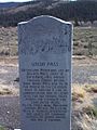
Historical marker describing first crossings.
-
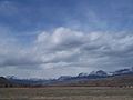
View of Union Pass
-
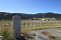
Near the historic marker for Union Pass on U.S. 26 & U.S. 287 in DuNoir, with the Wind River Mountains in the background.


