
Jackson Hole facts for kids

Jackson Hole is a beautiful valley located in the state of Wyoming, near the border with Idaho. It sits between two large mountain ranges: the Gros Ventre Range and the Teton Range. Early explorers, called "mountain men," used the word "hole" to describe a big valley surrounded by mountains. These valleys were great places for animals like beavers to live because they had rivers and streams.
Jackson Hole is about 55 miles (89 km) long and 6 to 13 miles (10 to 21 km) wide. It's a special type of valley called a graben, which means it formed when the land dropped down between two faults. The valley is quite high up, with an average elevation of 6,800 ft (2,100 m).
Contents
History of Jackson Hole
Long ago, Native Americans used the Jackson Hole valley for hunting and special ceremonies. People didn't live there all year round until the 1870s.
The first European-American to see the valley was John Colter in 1807. He had been part of the famous Lewis and Clark Expedition. After that, he explored the Rocky Mountains and discovered this amazing valley.
The town of Jackson got its name in 1893 from Margaret Simpson. She named it so people in the eastern United States could send mail there. The town was officially formed in 1914. It was named after David Edward "Davy" Jackson, who was a fur trapper. He trapped beavers in the area in the late 1820s. Davy Jackson was one of the first European-Americans to spend a whole winter in the valley.
The soil in Jackson Hole isn't great for growing crops. So, people used the valley for raising cattle. Soon, tourism became very popular, especially with the creation of dude ranches, where visitors could experience ranch life.
Towns and Communities
The only official town in the valley is Jackson, which is located at the southern end. Other smaller communities in Jackson Hole include Hoback, Kelly, Moose, Moran Junction, Teton Village, and Wilson.
West of Jackson, Teton Pass crosses the southern part of the Teton Mountains. This pass leads to Alta on the other side of the Tetons, and also to towns in Idaho like Victor and Driggs. This area was once called Pierre's Hole and was a meeting spot for fur trappers in 1832.
Many elk come to the valley to graze during the winter. Tourists can even take fun sleigh rides to see them! Jackson Hole is a popular place for visitors all year. People love to ski at places like Jackson Hole Mountain Resort, Snow King, and Grand Targhee Resort. The nearby Grand Teton National Park and Yellowstone National Park are also huge attractions.
Geography of the Valley

The valley is surrounded by mountains: the Teton Range to the west and the Gros Ventre Range to the east. A big part of the valley, including much of the Teton Range and Jackson Lake, is inside Grand Teton National Park.
The city of Jackson is at the southern end of the valley. Between Jackson and the park, you can find the "Glacier View Turnout" on U.S. Route 26. This spot offers a great view of Teton Glacier on the north side of Grand Teton. You'll also find the National Elk Refuge here, which is home to the largest elk herd in the world!
The Snake River flows through the entire valley. It starts in Yellowstone National Park in the north and exits through the Snake River Canyon at the southern tip. Blacktail Butte is a noticeable hill that rises from the valley floor. The valley's average elevation is over 6,500 ft (2,000 m) above sea level.
Because it's so high up and surrounded by steep mountains, winter nights in the valley can get very cold. Cold air from the snow-covered ground sinks down into the valley. In 1993, the temperature dropped to an incredible −56 °F (−49 °C)! The coldest temperature ever recorded in Wyoming was also in this valley, at Moran, reaching −66 °F (−54 °C) in 1933. Summers, however, are warm and pleasant because of the surrounding mountains.
Economy and Tourism
Jackson Hole Airport is the biggest and busiest commercial airport in Wyoming. It's also the only airport in the United States located inside a National Park! The airport follows strict rules to keep noise down and its buildings are low to the ground. This helps it fit in with Grand Teton National Park. Flying in winter can sometimes be tricky due to weather. Major airlines offer flights to the valley, some of which are only available in summer and winter.
In 2016, the Jackson Hole Tourism website set up 20 live webcams of Jackson's town square. This helped boost tourism, and now thousands of people watch these live streams at any given time. In 2017, Jackson Hole was even named the best campsite in Wyoming by MSN.com.
The community also hosts the Jackson Hole Economic Symposium each year. This is a meeting where important bankers, government officials, and experts from around the world come together. They discuss big economic issues and ideas.
Jackson Hole in Popular Culture
Jackson Hole has been featured in many movies! Some films set or filmed here include 3 Bad Men (1926), The Big Sky (1952), Shane (1953), Spencer's Mountain (1963), Any Which Way You Can (1980), The Mountain Men (1980), Rocky IV (1985), Dances with Wolves (1990), and Django Unchained (2012).
It's also a major location in the video games The Last of Us (2013) and The Last of Us Part II (2020). In these games, the town of Jackson is home to a large group of people surviving in a world after a big disaster.
The famous rapper Kanye West recorded his album Ye (2018) while living in Jackson Hole. The album cover even shows a picture of the Teton mountains that he took with his iPhone! Other albums recorded here by Kanye West and other artists include Kids See Ghosts (with Kid Cudi), Nas's Nasir, Pusha T's Daytona, and Teyana Taylor's K.T.S.E.. These albums are often called the "Wyoming Sessions."
Famous People Who Live Here
Jackson Hole has become a second home for many celebrities. This is partly because Wyoming has certain tax benefits. Some famous people who have homes here include Sandra Bullock, RuPaul Charles, Kanye West and Kim Kardashian, Nikki Sixx, and Harrison Ford.
Gallery
-
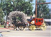
Jackson Square
-
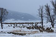
National Elk Refuge
-
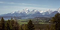
Teton Range
-
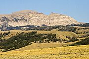
The "Sleeping Indian" series of rock formations on Sheep Mountain
-
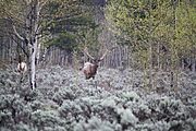
Elk in the wild

.jpg)


See also
 In Spanish: Jackson Hole para niños
