
Yellowstone Lake facts for kids
Quick facts for kids Yellowstone Lake |
|
|---|---|

Yellowstone Lake as seen from space
|
|

Yellowstone Lake
Location in Wyoming

Yellowstone Lake
Location in the United States
|
|
| Location | Yellowstone National Park Teton County, Wyoming, U.S. |
| Coordinates | 44°28′N 110°22′W / 44.467°N 110.367°W |
| Primary inflows | Yellowstone River |
| Primary outflows | Yellowstone River |
| Basin countries | U.S. |
| Max. length | 20 mi (32 km) |
| Max. width | 15 mi (24 km) |
| Surface area | 136 sq mi (350 km2) |
| Average depth | 139 ft (42 m) |
| Max. depth | 394 ft (120 m) |
| Shore length1 | 110 mi (180 km) |
| Surface elevation | 7,732 ft (2,357 m) |
| Islands | 6 |
| 1 Shore length is not a well-defined measure. | |
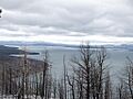
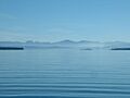
Yellowstone Lake is the biggest body of water in Yellowstone National Park. It sits high up, about 7,732 feet (2,357 m) above sea level. The lake covers a large area of 136 square miles (350 km2) and has 110 miles (180 km) of shoreline.
The lake is quite deep, with an average depth of 139 feet (42 m). Its deepest point is at least 394 feet (120 m). Yellowstone Lake is the largest freshwater lake in North America that is over 7,000 feet (2,100 m) high.
In winter, the lake usually freezes over by early December. The ice can be nearly 3 feet (0.91 m) thick. It often stays frozen until late May or early June. Some shallow areas with hot springs might not freeze completely.
Contents
Discovering Yellowstone Lake
The areas around Yellowstone Lake were home to Native Americans for a very long time. The first European person to see the lake was a trapper named John Colter in the early 1800s. Many fur traders likely visited the lake between 1820 and 1840.
In 1836, a trapper named Osborne Russell wrote about his visit. He described the lake as being about 100 miles around. He noted tall pine trees, many elk and deer, and hot springs. He also mentioned a steam vent that made a loud noise.
How the Lake Got Its Name
Over time, Yellowstone Lake has been called by different names. Early maps and journals show names like Yellow Stone and Yellow Stone Lake. Explorers William Clark and David Thompson used these names.
Some maps also called it Eustis Lake or Sublette's Lake. The name Yellowstone Lake officially appeared on maps in 1839. This was thanks to U.S. Army engineer Captain Washington Hood. The name has stayed the same ever since.
Early Explorations of the Lake
Before Yellowstone became a national park, several groups explored the lake. These expeditions helped people learn more about this amazing place.
In 1869, the Cook–Folsom–Peterson Expedition explored the lake. They described it as being about 10 miles wide and 16 miles long. They also noted two arms extending south. They saw many birds like ducks, geese, and swans.

The Washburn–Langford–Doane Expedition explored the lake in 1870. They were the first to describe the eastern and southern parts of the shoreline. Lieutenant Gustavus Cheyney Doane wrote about the lake's clear, deep blue water. He noted its high elevation of over 7,700 feet. He also mentioned that the lake was full of trout.

The Hayden Geological Survey of 1871 gave the most detailed scientific descriptions. They launched the Annie, the first European boat on the lake. They explored the islands and shoreline. This expedition also took the first photographs of the lake. These were taken by William Henry Jackson.
Dr. Ferdinand Vandeveer Hayden, the leader, wrote about their work. They used a special tool to measure distances. They also took soundings to map the lake's depth.
Plans to Build Dams
Between 1920 and 1937, there were ideas to build dams on the Yellowstone Lake outlet. Politicians and engineers wanted dams for flood control or to move water to other rivers. However, all these plans were eventually stopped.
Geology of Yellowstone Lake

The West Thumb area of the lake is famous for its hot springs. You can find geysers, fumaroles, and hot springs both on the shore and in the lake itself.
Since 2004, the ground under the lake has been rising. This shows that there is more geological activity happening. Scientists have found a "bulge" about 2,000 feet (610 m) long and 100 feet (30 m) high under the lake. This area has many faults and hot springs.
Yellowstone Lake sits in a large caldera. This caldera formed 640,000 years ago after a huge volcanic eruption. The original lake was about 200 feet (61 m) higher than it is today. It used to stretch north into Hayden Valley.
It is believed that Yellowstone Lake once drained south into the Pacific Ocean through the Snake River. Today, the lake drains north through the Yellowstone River. This river then flows over the famous upper and lower falls.
In the 1990s, scientists found that two volcanic areas, called "resurgent domes," are rising again. These domes can rise or fall each year. The rising of the Sour Creek dome is causing the lake to "tilt" southward. This means the north shore has more sandy beaches, and the southern parts of the lake are getting flooded.
Hayden Valley was once part of Yellowstone Lake. It has fine lake sediments covered by glacial till. This mix of soil makes the valley marshy. That is why not many trees grow there.
Fishing and Boating

Angling (fishing) for Yellowstone cutthroat trout has always been popular. Early explorers and tourists enjoyed fishing here. In the late 1800s, people tried to put other fish like Atlantic Salmon into the lake. But these new fish did not survive.
Today, only native cutthroat trout and non-native Lake trout live in the lake. Fishing is allowed from June 15 to the first Sunday in November. All cutthroat trout caught must be released back into the water.
Non-native Lake trout were found in Yellowstone Lake in 1994. They are believed to have been introduced around 1989. These Lake trout have caused the cutthroat trout population to drop. The National Park Service has a program to remove Lake trout from the lake. Any Lake trout caught by anglers must be killed.
Boating has been allowed on the lake since 1890. Today, you can use powerboats, sailboats, canoes, and kayaks. You need a Yellowstone Boating Permit. There is a marina at Bridge Bay and a boat ramp at Grant Village.
Some areas in the southern parts of the lake have speed limits or are no-motor zones. This helps protect wildlife. Access to some islands is also restricted. You can rent boats at Bridge Bay Marina. Many backcountry campsites along the southern shore can only be reached by boat. There are also hiking trails that lead to the lake shore.
Images for kids
-
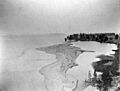
Yellowstone Lake's outlet (1871)
-
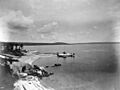
The southwest arm of Yellowstone Lake looking north (1871)
-
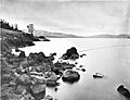
The eastern shoreline of Yellowstone Lake (1878)
-
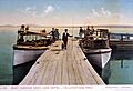
A photo of boats on Yellowstone Lake by F. Jay Haynes
-
A scenic photo of Yellowstone Lake by Ansel Adams (1942)
-
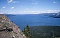
Yellowstone Lake as seen from Two Ocean Plateau looking north (1963)
-
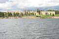
Yellowstone Lake Hotel as seen from Yellowstone Lake
-
A rainbow hanging over Yellowstone Lake
-
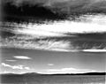
Yellowstone Lake on a stormy day
-
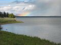
Yellowstone Lake at dawn


See also
 In Spanish: Lago Yellowstone para niños
