
Yellowstone Falls facts for kids
Quick facts for kids Upper Yellowstone Falls |
|
|---|---|
.jpg) |
|
| Lua error in Module:Infobox_mapframe at line 185: attempt to index field 'wikibase' (a nil value). | |
| Location | Yellowstone National Park, Park County, Wyoming, United States |
| Coordinates | 44°42′46″N 110°29′59″W / 44.71278°N 110.49972°W |
| Total height | 109 feet (33 m) |
| Watercourse | Yellowstone River |
| Lower Yellowstone Falls | |
|---|---|
 |
|
| Lua error in Module:Infobox_mapframe at line 185: attempt to index field 'wikibase' (a nil value). | |
| Location | Yellowstone National Park |
| Coordinates | 44°43′05″N 110°29′46″W / 44.71806°N 110.49611°W |
| Total height | 308 feet (94 m) |
| Watercourse | Yellowstone River |
The Yellowstone Falls are two amazing waterfalls found on the Yellowstone River. They are located inside Yellowstone National Park in Wyoming, United States. As the Yellowstone River flows north from Yellowstone Lake, it first drops over the Upper Yellowstone Falls. Just a short distance downstream, about 400 meters (a quarter mile), it plunges over the Lower Yellowstone Falls. After these falls, the river enters the incredible Grand Canyon of the Yellowstone, which can be as deep as 304 meters (1,000 feet)!
Contents
Discover Upper Yellowstone Falls
The Upper Yellowstone Falls (44°42′46″N 110°29′59″W / 44.71278°N 110.49972°W) are about 33 meters (109 feet) tall. This is like a 10-story building! The top edge of these falls shows where two different types of lava meet. There's a strong, hard lava flow called rhyolite and a weaker, glass-like lava that has worn away more easily over time.
Explore Lower Yellowstone Falls
The Lower Yellowstone Falls are the biggest waterfalls by water volume in the Rocky Mountains of the United States. These falls (44°43′05″N 110°29′46″W / 44.71806°N 110.49611°W) are a huge 94 meters (308 feet) high. That's almost twice as tall as Niagara Falls!
How Big is Lower Yellowstone Falls?
The amount of water rushing over the Lower Yellowstone Falls changes with the seasons. In autumn, about 19 cubic meters (680 cubic feet) of water flow over the falls every second. But in late spring, when snow melts, this can jump to an amazing 238 cubic meters (8,400 cubic feet) per second! Even though a lot of water flows, it's still less than Niagara Falls. The Yellowstone River is only about 21 meters (70 feet) wide at the Lower Falls. In comparison, the Niagara River is about 792 meters (2,600 feet) wide where it goes over Horseshoe Falls.
A History of Discovery
People have known about the Yellowstone Falls for a very long time. Native American tribes likely knew about them for centuries. The first European to probably see the falls was a French fur trapper named Baptise Ducharme. He said he saw them in 1824, 1826, and 1839.
Early Explorers and Maps
Later, in 1846, explorer Jim Bridger and his friend James Gremmell also claimed to have visited the falls. In 1851, Bridger even drew a map for a missionary, Father Pierre-Jean De Smet, showing where the falls were. A private group of three explorers, the Cook–Folsom–Peterson Expedition, officially named the falls in 1869.
Documenting the Falls
The very first pictures of the falls were drawings made by Private Charles Moore in 1870. He was part of the Washburn-Langford-Doane Expedition. Then, during the Hayden Expedition in 1871, the falls were captured in photographs by William Henry Jackson. Later, they were painted by the famous artist Thomas Moran. In 1887, Frank Jay Haynes took the first winter photos of the Lower Falls.
Over the years, people had different ideas about how tall the Lower Falls were. In 1851, Jim Bridger thought it was 250 feet high. One newspaper even claimed it was "thousands of feet" tall! A map from 1869 first called it "Lower Falls" and estimated its height at 350 feet. Today, we know the Lower Falls are 308 feet tall.
How to See the Falls Today
Today, it's easy to see these incredible waterfalls from many different spots! A road called the Canyon loop road runs along the west side of the canyon. There are several places to park your car and enjoy the views.
Best Viewing Spots
One trail leads right down to the edge of the Lower Falls. It's a steep walk, about 600 meters (a third of a mile). Another famous path is Uncle Tom's Trail, which goes down from the east side. It uses a series of stairs built into the cliffs, giving you amazing views.
The Lower Falls area is located just south and east of Canyon Village in Yellowstone National Park. You can take a one-way loop drive starting south from Canyon Junction. This drive takes you to the edge of the Grand Canyon of the Yellowstone and offers four different viewpoints. The first stop is the trail that leads to the very top of the Lower Falls. The drive continues east and north past the other viewpoints, eventually rejoining the main Grand Loop road.
Images for kids
-
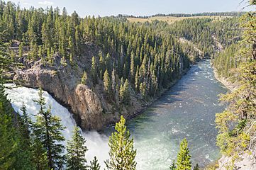
Upper Falls and downstream view
-
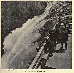
Brink of Upper Falls, 1916
-
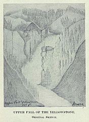
Upper Falls by Private Moore, 1870
-
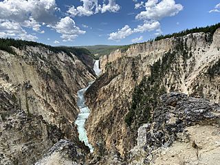
Lower Falls in Grand Canyon of Yellow Stone from Artist Point
-
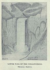
Lower Falls by Private Moore, 1870
-
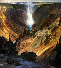
Lower Falls by Thomas Moran, 1871
-
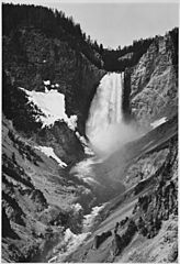
Lower Falls by Ansel Adams, 1941


