
Wind River Indian Reservation facts for kids
Quick facts for kids
Wind River Indian Reservation
|
|||
|---|---|---|---|
.jpg)
Wind River Range
|
|||
|
|||

Location in Wyoming
|
|||
| Tribes | Eastern Shoshone Northern Arapaho |
||
| Country | United States | ||
| State | Wyoming | ||
| Counties | Fremont Hot Springs |
||
| Headquarters | Fort Washakie | ||
| Government | |||
| • Body | Business Councils | ||
| Area | |||
| • Total | 3,532.010 sq mi (9,147.86 km2) | ||
| • Land | 3,473.272 sq mi (8,995.73 km2) | ||
| Population
(2017)
|
|||
| • Total | 27,088 | ||
| • Density | 7.66929/sq mi (2.96113/km2) | ||
| Website | |||


The Wind River Indian Reservation is a special area in west-central Wyoming. It is home to two Native American tribes: the Eastern Shoshone and the Northern Arapaho. This reservation stretches about 60 miles (97 km) east to west and 50 miles (80 km) north to south. It is located in the Wind River Basin and includes parts of the Wind River Range, Owl Creek Mountains, and Absaroka Range.
The Wind River Indian Reservation is the seventh-largest reservation in the United States by land size. It is also the fifth-largest by population. The total area, including land and water, is about 3,532 square miles (9,148 km²). This reservation makes up over one-third of Fremont County and more than one-fifth of Hot Springs County.
In 2010, about 26,490 people lived on the reservation. Around 15,000 of these residents are non-Native Americans living on lands that were given up by the tribes, including the town of Riverton. The main offices for the tribes are in Fort Washakie. The Shoshone Rose Casino and the Wind River Hotel and Casino are the only casinos in Wyoming.
Contents
Ancient History of the Wind River Area
The Shoshone people have lived in this area for a very long time. Scientists who study old cultures have found tools and items from the Tukudika Mountain Shoshone, also known as the Sheepeater tribe. These items, like soapstone bowls, were used here from the early 1800s, going back thousands of years. People who are descendants of the Mountain Shoshone still live on the Wind River Indian Reservation today.
The unique Dinwoody petroglyph style comes from central Wyoming, including the Wind River Basin. Petroglyphs are ancient rock carvings. Experts believe these carvings were made by the ancestors of the Tukudika or Mountain Shoshone Sheepeaters. Some figures in these carvings match characters from Shoshone stories, like Pa waip, a water spirit woman.
Tribal Life Before the Reservation
The Wind River Indian Reservation is located where the Great Basin culture of the Shoshone met the Great Plains tribal cultures. For many centuries, different tribes used this area for hunting and sometimes for raids.
After 1800, historical records show that the Shoshone, Crow, Cheyenne, Arapaho, Blackfeet, and Lakota tribes were all in the Wind River Basin. These tribes came to the area for various reasons, including finding food. Old trapper records describe huge herds of bison in the Wind River Basin, so many that they would raise massive clouds of dust.
In the 1700s, the Shoshone largely controlled much of what is now western Wyoming. This was because they were among the first northern tribes to get horses from Spanish traders in the Southwest. The Shoshone's power in western Wyoming lessened as other tribes also got horses. However, in the 1820s, the Shoshone started to become powerful again by trading for firearms.
The Shoshone often used the Wind River Basin as a place to stay in winter. They also used it as a path to hunting grounds further east. Other tribes, like the Crow, Cheyenne, and Arapaho, also moved into the Great Plains and sometimes into Shoshone territory. By the mid-1800s, many of these tribes would enter the Wind River valley, which became a contested area.
The Crow tribe was very strong in the Wind River Valley in the mid-1800s. They used the area for winter and fought with Shoshones who came there. However, the Crow's power in the Wind River Valley ended when Washakie, the Shoshone Chief, defeated a Crow chief in a one-on-one fight. This happened at Crowheart Butte sometime in the late 1850s or early 1860s.
The Fort Bridger Treaty Council of 1868 officially made the Wind River Valley the exclusive territory of the Shoshone. This agreement replaced the Crow's earlier claims from the 1851 Fort Laramie treaty.
The Reservation Era Begins
The Wind River Indian Reservation was first called the Shoshone Indian Reservation. It was created by an agreement between the United States and the Eastern Shoshone Nation at the Fort Bridger Treaty Council of 1868. This agreement greatly reduced the Shoshone's land, which used to be over 44 million acres (178,000 km²). Later, after a court case called United States v. Shoshone Tribe of Indians, the Arapaho tribe also gained legal rights to the reservation. It was then renamed the Wind River Indian Reservation.

The Shoshone leader Washakie liked this area and had fought the Crow tribe to keep it. In 1867, gold was found at South Pass. The U.S. government wanted to stop tribes from attacking mining camps. So, they placed the Shoshone reservation in the Wind River Valley to act as a buffer. The U.S. hoped that tribes like the Crow and Arapaho would attack the Shoshone instead of the miners.
There were several conflicts between tribes in the Wind River region in the 1860s and 1870s. For example, in June 1874, Shoshones and U.S. cavalry attacked the Arapaho at the Bates Battlefield.
A military post called Camp Augur was set up near what is now Lander in 1869. Its name was changed to Camp Brown in 1870. In 1871, the post moved to the current site of Fort Washakie. The name was changed again in 1878 to honor Chief Washakie, who was an ally of the United States. The fort was used by the military until 1909.
Sacagawea, a famous guide for the Lewis and Clark Expedition, was later buried here. Her son, Jean Baptiste Charbonneau, who was a child on the expedition, has a memorial stone in Fort Washakie.
A government school and hospital operated for many years east of Fort Washakie. Arapaho children often stayed here during the school year. The village of Arapahoe was first set up to give supplies to the Arapaho tribe. Irrigation systems were built to help with farming and ranching in the dry area.
In 1904, the Eastern Shoshone and Northern Arapaho tribes sold a part of the reservation north of the Wind River to the United States. This land was then opened for white settlement. The city of Riverton was developed on some of this land. Later, because large parts of this land were not settled, the sold portion of the reservation was given back to the Eastern Shoshone and Northern Arapaho tribes.
Arapaho Settlement on Wind River
In the winter of 1878-79, the U.S. Army brought the Northern Arapaho to the Shoshone's Fort Washakie Agency. This decision to place the Arapaho near their historic enemies, the Shoshone, had big effects on their history and politics.

The Arapaho did not want to live permanently on a reservation shared by the Sioux. They wanted their own reservation. Arapaho leaders hoped for a home closer to the Rocky Mountains, as their way of life included hunting in the mountains.
To gain favor with the U.S. Army, Arapaho leaders like Chief Black Coal helped the Army as scouts against other tribes. Army officers supported the idea of an Arapaho reservation in eastern Wyoming. However, the U.S. government had mostly stopped making treaties for new reservations after 1868.
In 1878, the U.S. Army decided to place the Arapaho at Fort Washakie Agency as a temporary solution. This was because the Arapaho were hungry and poor, and did not want to live near the Sioux. Even though the Shoshone had treaty rights to decide which tribes could live on their reservation, the Arapaho were placed there.
This "temporary" placement of the Arapaho at Fort Washakie became permanent. The U.S. government never moved the tribe again. The Arapaho hoped for their own reservation until 1890. In later land deals, the government treated the Arapaho as if they were part-owners of the reservation. This was despite the Shoshone's protests that the Arapaho had no legal claim.
It wasn't until a 1938 U.S. Supreme Court case, United States v. Shoshone Tribe of Indians, that the government admitted it had wrongly given Shoshone land to the Arapaho. After this, a new land deal officially made the Arapaho half-owners of the tribal lands and resources. The Shoshone Indian Reservation was then officially renamed the Wind River Indian Reservation.
This complex history of how the Arapaho came to the reservation still affects how the two tribes interact today. Over time, people from both tribes have married each other, building connections. However, both tribes still work to keep their own separate identities and governments strong.
Modern Times and Conservation
In the 1970s and 1980s, some oil and gas companies were found to be stealing oil from the Eastern Shoshone and Northern Arapaho tribes. This led to changes in how these companies operated.
In 2011, there were 3,737 Shoshone people and 8,177 Arapaho people living on the reservation. The reservation has about 1.8 million acres (7,300 km²) of tribal land, with 180,387 acres (730 km²) set aside as wilderness.
Land and Wildlife Conservation
The Wind River Indian Reservation created a 180,000-acre (730 km²) roadless area in the Wind River Range in the 1930s. This was many decades before the national Wilderness Act of 1964 was passed.

The tribes have successfully brought back populations of large animals, known as big game. These include moose, elk, mule deer, whitetail deer, bighorn sheep, and pronghorn antelope. They have also created hunting rules to protect these animals. In November 2016, the Shoshone brought ten bison back to the reservation. The plan is to grow this herd to 1,000 bison. These were the first bison seen on the Wind River Reservation since 1885. The Northern Arapaho also started their own bison herd in 2019.
Visiting the Reservation
Places to Stay and Learn
For visitors, there are hotels at the Wind River Casino and the Shoshone Rose Casino. You can learn about the cultures at the Eastern Shoshone Cultural Center and library in Fort Washakie. The Northern Arapaho Experience Room at the Wind River Hotel and Casino also offers cultural displays. The Museum of the Rockies in Lander has weekly powwow dancing shows during the summer.
Outdoor Activities
Visitors can go fishing and hiking on the Wind River Indian Reservation. You need to buy a tribal fishing license from local stores. This license lets you access fishing areas on the southern part of the reservation, including a roadless area in the beautiful Wind River Range. If you want to hike or climb closer to Gannett Peak, you can hire a guide. The reservation also licenses companies in Thermopolis that offer whitewater rafting and fishing trips in the amazing Wind River Canyon.
Powwows and Celebrations
The Wind River Country offers chances for visitors to see and join in important cultural events.
You can attend public powwows. There are three main celebrations each year: the Eastern Shoshone Powwow in June, the Ethete Celebration in July, and the Northern Arapaho Powwow in September. These ceremonies begin on Friday nights and include feasting, singing, and dancing. Festivities continue on Saturdays and Sundays.
A key part of the powwow is seeing the dancers' special clothing, called regalia. Each piece is unique and handmade, often with feathers, shells, bones, and beadwork. The dances and music are traditional and special to each tribe. The drumbeat is considered sacred, representing the heartbeat of the tribe. Powwows usually have free admission.
Current Topics
Life on the Wind River Indian Reservation has a complicated history. The community shows strong cultural survival and adaptation. However, it also faces challenges from past events, like losing land and forced cultural changes.
Health Services
There are two health clinics on the reservation. One is in Arapahoe, and the other is in Fort Washakie. These clinics offer many services, including mental health support, dental care, and medical services.
Environmental Concerns
Some residents of the Wind River Reservation are concerned about environmental issues. They believe that a former uranium mill and contamination nearby might be linked to health problems. The mill processed uranium from 1958 to 1963. Even though it closed, waste materials were left behind. In 1988, the Department of Energy (DOE) found that the soil and water were contaminated. The DOE believes the land will clean itself naturally over time. However, in 2010, contamination levels were recorded as much higher than allowed for drinking water. Tribal officials are worried about their water sources.
Relationship with Arapahoe High School
In 1993, the Northern Arapaho Tribe on the Wind River Reservation started a special relationship with a high school in Centennial, Colorado. This was to help people understand the two different cultures. The school's mascot is the "Arapahoe Warrior," and the tribe approved this mascot. The image of the mascot was drawn by Northern Arapaho artist Wilbur Antelope. This agreement created a lasting bond between the school and the tribe. It reminds everyone of Elder Anthony Sitting Eagle's words: "Always take care of one another."
As part of this agreement, Arapahoe High School and the Arapaho Nation visit each other every year. When the Arapaho tribe visits the school, they hold a special assembly. Students from the school join the visitors in the gymnasium, which is named after Arapaho Elder Anthony Sitting Eagle. The Arapaho tribe performs traditional dances, and tribal leaders speak to the students. When the students visit the Wind River Reservation, they learn more about the Arapaho Nation's culture. This tradition continues today and helps students learn a lot.
Images for kids
-
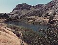
The Wind River at the Wind River Indian Reservation, Wyoming
-
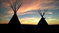
Sunset with tepees on the Wind River Indian Reservation
-
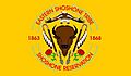
Flag of the Eastern Shoshone tribe
-
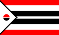
Flag of the Northern Arapaho tribe


Communities
- Arapahoe
- Boulder Flats
- Crowheart
- Embar
- Ethete
- Fort Washakie
- Hudson (part, population 72)
- Johnstown
- Kinnear
- Midvale
- Pavillion
- Riverton
- Willow Creek
