Dallas County, Iowa facts for kids
Quick facts for kids
Dallas County
|
|
|---|---|

|
|

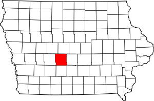
Location within the U.S. state of Iowa
|
|
 Iowa's location within the U.S. |
|
| Country | |
| State | |
| Founded | January 13, 1846 |
| Named for | George M. Dallas |
| Seat | Adel |
| Largest city | Waukee |
| Area | |
| • Total | 592 sq mi (1,530 km2) |
| • Land | 588 sq mi (1,520 km2) |
| • Water | 3.3 sq mi (9 km2) 0.5% |
| Population
(2020)
|
|
| • Total | 99,678 |
| • Density | 168.38/sq mi (65.01/km2) |
| Time zone | UTC−6 (Central) |
| • Summer (DST) | UTC−5 (CDT) |
| Congressional district | 3rd |
Dallas County is a county found in the state of Iowa in the United States. In 2020, about 99,678 people lived there. This makes it the seventh-biggest county in Iowa by population.
Between 2010 and 2020, Dallas County grew faster than almost any other county in Iowa. It was also one of the fastest-growing counties in the whole country. The main town, or county seat, is Adel. The biggest city in the county is Waukee.
The county got its name from George M. Dallas. He was the Vice President of the United States under President James K. Polk. The nearby Polk County is named after President Polk. Dallas County is part of the larger Des Moines metropolitan area.
Contents
History of Dallas County
The land that is now Dallas County used to belong to the Sac and Fox people. They gave this land to the United States in a special agreement signed on October 11, 1842.
On January 13, 1846, the government of the Iowa Territory decided to create twelve new counties. They also set their borders. Dallas County was named after George M. Dallas, who was the Vice President from 1845 to 1849.
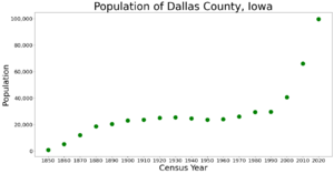
In 1847, the people living in the county voted. They chose a town called Penoch to be the county seat. The name of this town was changed to Adel in 1849. Many people moved to Dallas County to start new homes and farms. By 1870, the number of people living there had grown to more than 12,000.
Geography and Roads
According to official records, Dallas County covers a total area of about 592 square miles. Most of this area, about 588 square miles, is land. The rest, about 3.3 square miles, is water.
Main Roads in Dallas County
Many important roads run through Dallas County. They help people travel around the county and to other places.
 Interstate 80 goes east-northeast through the southern part of the county. It passes through towns like Dexter and De Soto on its way to Des Moines.
 U.S. Highway 6 starts in Adel. It then goes east through the middle of the county towards Des Moines.
 U.S. Highway 169 runs north and south through the center of the county. It connects towns like Bouton, Adel, and De Soto.
 Iowa Highway 17 starts near Granger. It runs north along the eastern edge of the county into Boone County.
 Iowa Highway 44 goes east and west through the middle of the county. It passes through Dallas Center.
 Iowa Highway 141 runs east across the northern part of the county. It goes through Dawson, Perry, Bouton, and Woodward. Then it turns southeast into Polk County at Granger.
 Iowa Highway 144 starts near Perry. It goes north into Boone County.
 Iowa Highway 210 starts where it meets Iowa 141. It goes north to Woodward and continues into Boone County.
Neighboring Counties
Dallas County shares its borders with several other counties:
- Adair County to the southwest
- Boone County to the north
- Greene County to the north and northwest
- Guthrie County to the west
- Madison County to the south
- Polk County to the east
- Warren County to the southeast
Population Changes Over Time
| Historical population | |||
|---|---|---|---|
| Census | Pop. | %± | |
| 1850 | 854 | — | |
| 1860 | 5,244 | 514.1% | |
| 1870 | 12,019 | 129.2% | |
| 1880 | 18,746 | 56.0% | |
| 1890 | 20,479 | 9.2% | |
| 1900 | 23,058 | 12.6% | |
| 1910 | 23,628 | 2.5% | |
| 1920 | 25,120 | 6.3% | |
| 1930 | 25,493 | 1.5% | |
| 1940 | 24,649 | −3.3% | |
| 1950 | 23,661 | −4.0% | |
| 1960 | 24,123 | 2.0% | |
| 1970 | 26,085 | 8.1% | |
| 1980 | 29,513 | 13.1% | |
| 1990 | 29,755 | 0.8% | |
| 2000 | 40,750 | 37.0% | |
| 2010 | 66,135 | 62.3% | |
| 2020 | 99,678 | 50.7% | |
| 2023 (est.) | 111,092 | 68.0% | |
| U.S. Decennial Census 1790-1960 1900-1990 1990-2000 2010-2018 |
|||
What the 2020 Census Shows
The 2020 census counted 99,678 people living in Dallas County. This means there were about 169 people for every square mile. Most people, about 94.19%, said they belonged to one race. There were 41,125 homes in the county, and 38,291 of them were lived in.
| Race | Number of People | Percentage |
|---|---|---|
| White (not Hispanic) | 81,708 | 82% |
| Black or African American (not Hispanic) | 2,657 | 2.7% |
| Native American (not Hispanic) | 137 | 0.14% |
| Asian (not Hispanic) | 4,987 | 5% |
| Pacific Islander (not Hispanic) | 32 | 0.03% |
| Other/Mixed (not Hispanic) | 3,642 | 3.7% |
| Hispanic or Latino | 6,515 | 6.54% |
Towns and Communities
Dallas County has many different towns and communities. Some of these are cities, and some are smaller, unincorporated areas.
Cities in Dallas County
- ‡ These cities are partly in Polk County too.
Unincorporated Communities
These are smaller communities that are not officially organized as cities:
Townships
A township is a small area of land within a county. Dallas County is divided into several townships:
- Adams
- Adel
- Beaver
- Boone
- Colfax
- Dallas
- Des Moines
- Grant
- Lincoln
- Linn
- Spring Valley
- Sugar Grove
- Union
- Van Meter
- Walnut
- Washington
How Cities Rank by Population
This table shows the cities and towns in Dallas County, ranked by how many people lived there in 2020.
† This symbol means it is the county seat, or main town.
| Rank | City/Town | Type | Population (2020 Census) |
|---|---|---|---|
| 1 | West Des Moines (mostly in Polk County) | City | 68,723 |
| 2 | Urbandale (partially in Polk County) | City | 45,580 |
| 3 | Waukee | City | 23,940 |
| 4 | Clive (partially in Polk County) | City | 18,601 |
| 5 | Grimes (mostly in Polk County) | City | 15,392 |
| 6 | Perry | City | 7,836 |
| 7 | † Adel | City | 6,153 |
| 8 | Dallas Center | City | 1,901 |
| 9 | Granger (partially in Polk County) | City | 1,654 |
| 10 | Van Meter | City | 1,484 |
| 11 | Woodward | City | 1,346 |
| 12 | De Soto | City | 915 |
| 13 | Redfield | City | 731 |
| 14 | Dexter | City | 640 |
| 15 | Minburn | City | 325 |
| 16 | Linden | City | 200 |
| 17 | Dawson | City | 116 |
| 18 | Bouton | City | 127 |
Images for kids
See also
 In Spanish: Condado de Dallas (Iowa) para niños
 | Chris Smalls |
 | Fred Hampton |
 | Ralph Abernathy |


