Woodward, Iowa facts for kids
Quick facts for kids
Woodward, Iowa
|
|
|---|---|

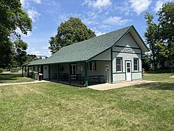
Railroad depot
|
|

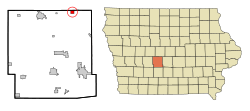
Location of Woodward, Iowa
|
|
| Country | |
| State | |
| County | Dallas |
| Area | |
| • Total | 3.65 sq mi (9.46 km2) |
| • Land | 3.65 sq mi (9.46 km2) |
| • Water | 0.00 sq mi (0.00 km2) |
| Elevation | 1,060 ft (320 m) |
| Population
(2020)
|
|
| • Total | 1,346 |
| • Density | 368.36/sq mi (142.24/km2) |
| Time zone | UTC-6 (Central (CST)) |
| • Summer (DST) | UTC-5 (CDT) |
| ZIP code |
50276
|
| Area code(s) | 515 |
| FIPS code | 19-86970 |
| GNIS feature ID | 2397375 |
Woodward is a city located in Dallas County, Iowa, in the United States. In 2020, about 1,346 people lived there. Woodward is part of the larger Des Moines metropolitan area. It is also home to the middle school and high school for the Woodward-Granger Community School District. The elementary school for the district is in Granger, a nearby town.
Contents
History of Woodward
Woodward began as a town when the Chicago, Milwaukee, and St. Paul Railway Company built its train lines through the area. The first name chosen for the town was Colton. However, another town already had that name. So, the name was changed to Woodward. The city officially became a city in August 1883. The first city council meeting happened on December 18, 1883. Mayor W.S. Craft led this first meeting.
Tornado in 2005
On November 12, 2005, a strong tornado hit Woodward. It also affected the city of Ames and other small towns in Iowa. This tornado caused a lot of damage to homes in the southeast and east parts of Woodward. Luckily, no one died in Woodward from this storm. The Discovery Channel show Destroyed In Seconds even featured this natural disaster in one of its episodes.
Geography and Location
Woodward is a city that covers about 3.65 square miles (9.46 square kilometers) of land. The entire area is land, with no water.
Population and People
The number of people living in Woodward has changed over time. Here's a quick look at how the population has grown:
| Historical populations | ||
|---|---|---|
| Year | Pop. | ±% |
| 1890 | 328 | — |
| 1900 | 550 | +67.7% |
| 1910 | 712 | +29.5% |
| 1920 | 868 | +21.9% |
| 1930 | 901 | +3.8% |
| 1940 | 895 | −0.7% |
| 1950 | 908 | +1.5% |
| 1960 | 967 | +6.5% |
| 1970 | 1,010 | +4.4% |
| 1980 | 1,212 | +20.0% |
| 1990 | 1,197 | −1.2% |
| 2000 | 1,200 | +0.3% |
| 2010 | 1,024 | −14.7% |
| 2020 | 1,346 | +31.4% |
| Source: and Iowa Data Center Source: |
||
What the 2020 Census Shows
In 2020, the census counted 1,346 people living in Woodward. There were 439 households and 265 families. The city had about 368 people per square mile. Most of the people living in Woodward were White (83.5%). Other groups included Black or African American (6.1%), Native American (0.6%), and Asian (0.7%). About 6.2% of the population was Hispanic or Latino.
The average age of people in Woodward was 34.9 years. About 32.9% of residents were under 20 years old. Also, 14.9% were 65 years old or older. The population was 57.4% male and 42.6% female.
What the 2010 Census Showed
The 2010 census reported 1,024 people in Woodward. There were 455 households. The population density was about 416 people per square mile. Most residents were White (95.3%). About 2.2% of the population was Hispanic or Latino.
The average age in 2010 was 40.4 years. About 22.8% of residents were under 18 years old. Also, 13.1% were 65 years or older. The city's population was 47.4% male and 52.6% female.
Education in Woodward
The Woodward-Granger Community School District is in charge of the public schools in Woodward. This district helps students get a good education.
Organizations in the Area
- The Woodward State Resource Center is located in Woodward.
- Woodward Academy is also in Woodward. It is a special program for teenage boys.
See also
 In Spanish: Woodward (Iowa) para niños
 | Kyle Baker |
 | Joseph Yoakum |
 | Laura Wheeler Waring |
 | Henry Ossawa Tanner |

