
De Soto, Iowa facts for kids
Quick facts for kids
De Soto, Iowa
|
|
|---|---|

De Soto water tower along Interstate 80
|
|

Location of De Soto, Iowa
|
|
| Country | |
| State | |
| County | Dallas |
| Area | |
| • Total | 1.75 sq mi (4.53 km2) |
| • Land | 1.75 sq mi (4.52 km2) |
| • Water | 0.00 sq mi (0.01 km2) |
| Elevation | 971 ft (296 m) |
| Population
(2020)
|
|
| • Total | 915 |
| • Density | 524.05/sq mi (202.28/km2) |
| Time zone | UTC-6 (Central (CST)) |
| • Summer (DST) | UTC-5 (CDT) |
| ZIP code |
50069
|
| Area code(s) | 515 |
| FIPS code | 19-21045 |
| GNIS feature ID | 2394474 |
| Website | http://desoto-ia.org/ |
De Soto is a small city in Dallas County, Iowa, United States. In 2020, about 915 people lived there. It is part of the larger Des Moines area.
Contents
A Look Back at De Soto's History
De Soto began in 1868. This was after the Chicago, Rock Island and Pacific Railroad built its tracks through the area. The city was named after a railroad official.
Where is De Soto?
De Soto is located in Iowa. The United States Census Bureau says the city covers about 1.52 square miles (3.94 square kilometers) of land.
Who Lives in De Soto?
| Historical populations | ||
|---|---|---|
| Year | Pop. | ±% |
| 1880 | 347 | — |
| 1890 | 328 | −5.5% |
| 1900 | 345 | +5.2% |
| 1910 | 356 | +3.2% |
| 1920 | 261 | −26.7% |
| 1930 | 319 | +22.2% |
| 1940 | 274 | −14.1% |
| 1950 | 280 | +2.2% |
| 1960 | 273 | −2.5% |
| 1970 | 369 | +35.2% |
| 1980 | 1,035 | +180.5% |
| 1990 | 1,033 | −0.2% |
| 2000 | 1,009 | −2.3% |
| 2010 | 1,050 | +4.1% |
| 2020 | 915 | −12.9% |
| Source: and Iowa Data Center Source: |
||
De Soto's Population in 2020
In 2020, the city had 915 people living in 354 households. There were 255 families. About 524 people lived in each square mile.
Most people (about 91.4%) were White. Other groups included Black or African American, Native American, Asian, and Pacific Islander. Some people were from two or more races. About 1.7% of the population was Hispanic or Latino.
In De Soto, 38.7% of households had children under 18. Many households (52.5%) were married couples. The average age in the city was 36.1 years. About 28.7% of residents were under 20 years old.
Education in De Soto
Students in De Soto attend schools in the Adel–De Soto–Minburn Community School District. This school district was created in 1993. It formed when the Adel–De Soto and Central Dallas school districts joined together.
Images for kids
-
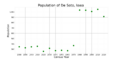
The population of De Soto, Iowa, from US census data

See also
 In Spanish: De Soto (Iowa) para niños
