Earlham, Iowa facts for kids
Quick facts for kids
Earlham, Iowa
|
|
|---|---|
| Motto(s):
"Plant roots. See them grow."
|
|

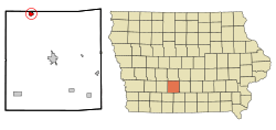
Location of Earlham, Iowa
|
|
| Country | |
| State | |
| County | Madison |
| Area | |
| • Total | 0.94 sq mi (2.45 km2) |
| • Land | 0.94 sq mi (2.45 km2) |
| • Water | 0.00 sq mi (0.00 km2) |
| Elevation | 1,102 ft (336 m) |
| Population
(2020)
|
|
| • Total | 1,410 |
| • Density | 1,492.06/sq mi (576.37/km2) |
| Time zone | UTC-6 (Central (CST)) |
| • Summer (DST) | UTC-5 (CDT) |
| ZIP code |
50072
|
| Area code(s) | 515 |
| FIPS code | 19-23340 |
| GNIS feature ID | 0456104 |
Earlham is a small city in Madison County, Iowa, in the United States. It's a part of the larger Des Moines area. In 2020, about 1,410 people lived there.
Contents
History of Earlham
Earlham started thanks to a man named David Hockett. In 1865, David, his wife Mary Jane, and their three children moved to the area. They traveled by ox team and wagon. They settled on 200 acres of land, which is where Earlham is today.
David Hockett helped the town grow by giving land to the Chicago, Rock Island and Pacific Railroad. He also sold some of his land for new buildings. Earlham officially became a town on April 26, 1870. The city was named after Earlham College, a Quaker school in Indiana.
Where is Earlham?
Earlham is located in Iowa at these coordinates: 41.493137 degrees North and 94.123661 degrees West.
The city covers a total area of about 0.97 square miles (2.45 square kilometers). All of this area is land, with no large bodies of water inside the city limits.
People of Earlham
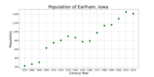
| Historical populations | ||
|---|---|---|
| Year | Pop. | ±% |
| 1870 | 222 | — |
| 1880 | 260 | +17.1% |
| 1890 | 302 | +16.2% |
| 1900 | 630 | +108.6% |
| 1910 | 749 | +18.9% |
| 1920 | 803 | +7.2% |
| 1930 | 897 | +11.7% |
| 1940 | 865 | −3.6% |
| 1950 | 771 | −10.9% |
| 1960 | 788 | +2.2% |
| 1970 | 974 | +23.6% |
| 1980 | 1,140 | +17.0% |
| 1990 | 1,157 | +1.5% |
| 2000 | 1,298 | +12.2% |
| 2010 | 1,450 | +11.7% |
| 2020 | 1,410 | −2.8% |
| Source: and Iowa Data Center Source: |
||
Every ten years, the United States counts its population. This is called a census. The census helps us understand how many people live in a place and what they are like.
Earlham's Population in 2020
In 2020, the census showed that 1,410 people lived in Earlham. There were 548 households, which are groups of people living in one home. About 384 of these households were families.
The city had about 1,492 people per square mile. Many homes had children under 18 living there. The average age of people in Earlham was about 39.5 years old.
- About 31% of residents were under 20 years old.
- About 16% were 65 years old or older.
- The number of males and females in the city was almost equal.
Education in Earlham
Students in Earlham attend schools that are part of the Earlham Community School District. This district provides education for children living in the city and the surrounding area.
See also
 In Spanish: Earlham (Iowa) para niños
 | Jackie Robinson |
 | Jack Johnson |
 | Althea Gibson |
 | Arthur Ashe |
 | Muhammad Ali |


