Sheldahl, Iowa facts for kids
Quick facts for kids
Sheldahl, Iowa
|
|
|---|---|

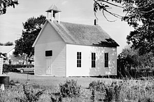
Sheldahl First Norwegian Evangelical Lutheran Church is listed on the National Register of Historic Places
|
|

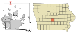
Location of Sheldahl, Iowa
|
|
| Country | |
| State | |
| Counties | Story, Polk, Boone |
| Area | |
| • Total | 0.80 sq mi (2.08 km2) |
| • Land | 0.80 sq mi (2.08 km2) |
| • Water | 0.00 sq mi (0.00 km2) |
| Elevation | 1,030 ft (310 m) |
| Population
(2020)
|
|
| • Total | 297 |
| • Density | 370.32/sq mi (142.93/km2) |
| Time zone | UTC-6 (Central (CST)) |
| • Summer (DST) | UTC-5 (CDT) |
| ZIP code |
50243
|
| Area code(s) | 515 |
| FIPS code | 19-72345 |
| GNIS feature ID | 2395867 |
Sheldahl is a small city in the state of Iowa, United States. It is unique because it is located in three different counties: Polk, Boone, and Story. In 2020, the city had a population of 297 people.
Sheldahl is part of a few larger areas. The part in Boone County is linked to the Boone area. The Story County part is connected to the Ames area. These two together form a larger combined area. The small section of Sheldahl in Polk County is part of the Des Moines metropolitan area.
Contents
History of Sheldahl
Early Settlement and City Status
The Sheldahl area was first settled on June 7, 1855. About 120 Norwegian immigrants moved there from Lisbon, Illinois. Among them were Osmond and Anna Sheldahl and their five children. The city of Sheldahl officially became a city on January 18, 1882.
Railroads and the High Trestle Trail
In the 1880s, the Chicago and Northwestern Railway built a train line through Sheldahl. Another railway, the Chicago, Milwaukee, St. Paul, and Pacific Railroad, connected to this line nearby.
Years later, in 2005, the Union Pacific Railroad sold a 25-mile section of this old railway. This section included the line that went through Sheldahl. The Iowa Natural Heritage Foundation bought it. This allowed for the creation of the High Trestle Trail. This trail is a popular place for walking and biking. Sheldahl has a special access point to the trail, with parking and restrooms.
Geography of Sheldahl
Sheldahl covers a total area of about 0.80 square miles (2.08 square kilometers). All of this area is land, meaning there are no lakes or large rivers within the city limits.
Population and People
| Historical populations | ||
|---|---|---|
| Year | Pop. | ±% |
| 1900 | 179 | — |
| 1910 | 202 | +12.8% |
| 1920 | 175 | −13.4% |
| 1930 | 209 | +19.4% |
| 1940 | 206 | −1.4% |
| 1950 | 211 | +2.4% |
| 1960 | 279 | +32.2% |
| 1970 | 285 | +2.2% |
| 1980 | 315 | +10.5% |
| 1990 | 315 | +0.0% |
| 2000 | 336 | +6.7% |
| 2010 | 319 | −5.1% |
| 2020 | 297 | −6.9% |
| Source: and Iowa Data Center Source: |
||
Sheldahl's Population in 2020
According to the 2020 census, 297 people lived in Sheldahl. There were 125 households and 97 families. The city had about 370 people per square mile.
Most of the people living in Sheldahl were White (91.2%). A small number were Black or African American (0.7%), Native American (0.3%), or Asian (0.7%). About 1% of the population was Hispanic or Latino.
About 31% of the households had children under 18 living with them. Most households (59.2%) were married couples. The average age of people in Sheldahl was 43.2 years old. About 24% of residents were under 20 years old.
Education in Sheldahl
Students in Sheldahl attend schools within the North Polk Community School District.
Notable People from Sheldahl
- Robert J. Hermann - He was the ninth Director of the National Reconnaissance Office. This office is part of the United States government and deals with spy satellites.
See also
 In Spanish: Sheldahl (Iowa) para niños
 | John T. Biggers |
 | Thomas Blackshear |
 | Mark Bradford |
 | Beverly Buchanan |

