
Marion County, Iowa facts for kids
Quick facts for kids
Marion County
|
|
|---|---|

Marion County Courthouse in Knoxville
|
|

Location within the U.S. state of Iowa
|
|
 Iowa's location within the U.S. |
|
| Country | |
| State | |
| Founded | 1845 |
| Named for | Francis Marion |
| Seat | Knoxville |
| Largest city | Pella |
| Area | |
| • Total | 571 sq mi (1,480 km2) |
| • Land | 555 sq mi (1,440 km2) |
| • Water | 16 sq mi (40 km2) 2.8% |
| Population
(2020)
|
|
| • Total | 33,414 |
| • Estimate
(2023)
|
33,770 |
| • Density | 58.52/sq mi (22.594/km2) |
| Time zone | UTC−6 (Central) |
| • Summer (DST) | UTC−5 (CDT) |
| Congressional district | 2nd |
Marion County is a county located in the state of Iowa in the United States. In 2020, about 33,414 people lived here. The main town, or county seat, is Knoxville.
The county is named after Francis Marion. He was a brave general from South Carolina. He fought in the American Revolutionary War, which was when America became independent.
Contents
Exploring Marion County's Land
According to the U.S. Census Bureau, Marion County covers a total area of about 571 square miles. Most of this area, about 555 square miles, is land. The rest, about 16 square miles, is water. This means about 2.8% of the county is covered by water.
Main Roads in Marion County
These are some of the important roads that go through Marion County:
 Iowa Highway 5
 Iowa Highway 14
 Iowa Highway 92
 Iowa Highway 163
 Iowa Highway 316
Neighboring Counties
Marion County shares its borders with several other counties:
- Jasper County to the north
- Mahaska County to the east
- Monroe County to the southeast
- Lucas County to the southwest
- Warren County to the west
Who Lives in Marion County?

The number of people living in Marion County has changed over many years. You can see how the population has grown or shrunk in the table below.
| Historical population | |||
|---|---|---|---|
| Census | Pop. | %± | |
| 1850 | 5,482 | — | |
| 1860 | 16,813 | 206.7% | |
| 1870 | 24,436 | 45.3% | |
| 1880 | 25,111 | 2.8% | |
| 1890 | 23,058 | −8.2% | |
| 1900 | 24,159 | 4.8% | |
| 1910 | 22,995 | −4.8% | |
| 1920 | 24,957 | 8.5% | |
| 1930 | 25,727 | 3.1% | |
| 1940 | 27,019 | 5.0% | |
| 1950 | 25,930 | −4.0% | |
| 1960 | 25,886 | −0.2% | |
| 1970 | 26,352 | 1.8% | |
| 1980 | 29,669 | 12.6% | |
| 1990 | 30,001 | 1.1% | |
| 2000 | 32,052 | 6.8% | |
| 2010 | 33,309 | 3.9% | |
| 2020 | 33,414 | 0.3% | |
| 2023 (est.) | 33,770 | 1.4% | |
| U.S. Decennial Census 1790-1960 1900-1990 1990-2000 2010-2018 |
|||
Looking at the 2020 Census

In 2020, the census counted 33,414 people in Marion County. This means there were about 58 people living in each square mile. Most people (96.24%) said they belonged to one race. About 91.15% were non-Hispanic White. Other groups included Black (0.87%), Hispanic (2.09%), Native American (0.21%), and Asian (1.20%). A small number were Native Hawaiian or Pacific Islander (0.06%). About 4.41% were of another race or more than one race.
There were 14,073 places where people could live (housing units). Out of these, 13,145 were being lived in.
Looking at the 2010 Census
The 2010 census showed that 33,309 people lived in Marion County. There were about 60 people per square mile. At that time, there were 13,914 housing units. Of these, 12,723 were occupied.
Towns and Communities
Marion County has several cities and smaller communities.
Cities in Marion County
Smaller Communities (Unincorporated)
These places are not officially cities or towns, but they are communities where people live:
Township Areas
Counties are often divided into smaller areas called townships. Here are the townships in Marion County:
- Clay
- Dallas
- Franklin
- Indiana
- Knoxville
- Lake Prairie
- Liberty
- Pleasant Grove
- Red Rock
- Summit
- Union
- Washington
How Big Are the Communities?

This table shows the population of the cities and towns in Marion County, based on the 2020 census. The largest city is at the top.
† This symbol means it's the county seat (the main town).
| Rank | City/Town/etc. | Type | Population (2020 Census) |
|---|---|---|---|
| 1 | Pella | City | 10,464 |
| 2 | † Knoxville | City | 7,595 |
| 3 | Pleasantville | City | 1,676 |
| 4 | Melcher-Dallas | City | 1,195 |
| 5 | Bussey | City | 387 |
| 6 | Harvey | City | 236 |
| 7 | Hamilton | City | 119 |
| 8 | Swan | City | 76 |
| 9 | Marysville | City | 44 |
Images for kids
-
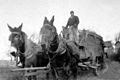
A farmer in Marion County with a wagon pulled by mules, around 1926.
-
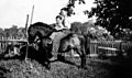
Two farm boys in Iowa riding a pony, around 1937.
-
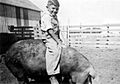
An Iowa farm boy riding a hog, around 1941.
-
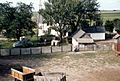
A farm house and barn yard near Pleasantville, 1957.
-
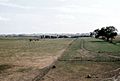
Cows grazing in a farm pasture, 1957.
-
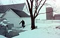
A farmer collecting coal in December 1957.
-
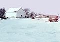
A farm barnyard in December 1957.
-
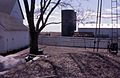
A farm barnyard with a silo, 1960.


See also
 In Spanish: Condado de Marion (Iowa) para niños
