
Ankeny, Iowa facts for kids
Quick facts for kids
Ankeny, Iowa
|
||
|---|---|---|
|
City
|
||

Ankeny City Hall
|
||
|
||
| Motto(s):
"Bringing it all together"
|
||

Location within Polk County and Iowa
|
||
| Country | ||
| State | ||
| County | Polk | |
| Incorporated | February 28, 1903 | |
| Government | ||
| • Type | Mayor-Council-Manager Government | |
| Area | ||
| • Total | 30.47 sq mi (78.92 km2) | |
| • Land | 30.47 sq mi (78.92 km2) | |
| • Water | 0.00 sq mi (0.00 km2) | |
| Elevation | 988 ft (301 m) | |
| Population
(2020)
|
||
| • Total | 67,887 | |
| • Estimate
(2023)
|
74,458 | |
| • Rank | 7th in Iowa | |
| • Density | 2,227.92/sq mi (860.21/km2) | |
| Time zone | UTC−6 (CST) | |
| • Summer (DST) | UTC−5 (CDT) | |
| ZIP codes |
50023, 50021, 50015
|
|
| Area code(s) | 515 | |
| FIPS code | 19-02305 | |
| GNIS feature ID | 2393960 | |
| Public Transit | ||

Ankeny is a city in Polk County, Iowa, United States. It is a suburb of Des Moines, which is the state capital. Ankeny is part of the larger Des Moines metropolitan area.
In 2020, Ankeny had a population of 67,887 people. This makes it the seventh largest city in Iowa. Ankeny is also one of the fastest-growing cities in the state. The city covers about 29 square miles.
Contents
History of Ankeny
Ankeny was started as a farming community on April 22, 1875. It was founded by John Fletcher Ankeny and Sarah "Sally" Ankeny. They bought 80 acres of land in 1874 for $1,600. The town officially became a city on February 28, 1903.
In 1881, the town of Ankeny had seven houses, a church, a train station, a store/post office, a stable, a blacksmith shop, a rooming house, a machine shop, and a school. Mail was not delivered to homes yet. Newspapers arrived by train every Friday.
A railroad line was built from Des Moines to Ames through Ankeny. This railroad was finished in 1874. Passenger train service started on July 11, 1880. In the 1800s, Ankeny's main industries were farming. They grew sorghum and raised pigs. Sorghum was processed at a local mill. Pigs were taken to market in Keokuk, Iowa.
Ankeny in the 20th Century
The local newspaper, Ankeny Times, first came out on May 17, 1902. Telephone service began in 1903. Electricity was available in some parts of the city by 1907. Most homes got electricity in 1919. This happened after the Central Light and Power Company built a power plant.
Ankeny's first volunteer fire department started in 1907. Four big fires damaged the downtown area between 1932 and 1940. But businesses were rebuilt each time.
In the early 1900s, coal mining became very important. Many companies opened mines near Ankeny. The Enterprise Coal Company used Ankeny as a company town. In 1914, it produced over 100,000 tons of coal. This made it one of the top coal producers in Iowa. In 1912, many people in Ankeny worked in coal mines.
World War II and After
Before the 1930s, most of Ankeny's land was used for farming. But manufacturing grew more important. During World War II, the U.S. government bought farms in 1941. They built a military ordnance plant there. The plant made ammunition from 1942 until 1945.
After World War II, Deere & Company bought the factory in 1947. They started making farm equipment there. It was renamed John Deere Des Moines Works. Iowa State University bought the land around the plant for farming research.
In 1958, mail delivery to homes began. Another local newspaper, the Ankeny Press-Citizen, started that same year. In 1961, Ankeny's status was changed from a town to a city. The Ankeny Times newspaper stopped publishing in 1966.
Later 20th Century Changes
In 1967, Des Moines Area Community College (DMACC) bought land in Ankeny. They started building a new main campus there in 1968. Construction continued through the 1970s. Also in 1967, Faith Baptist Bible College and Theological Seminary moved to Ankeny. It had been in Omaha, Nebraska.
An F4 tornado hit Ankeny in June 1974. It also affected Des Moines and other nearby towns. Two people died and 50 were injured. Local stores in Ankeny offered discounts after the tornado.
In 1989, people started planning for a local airport. The Ankeny Regional Airport opened in February 1994. The first flight was a small plane called a Cessna 182 Skylane.
Ankeny in the 21st Century
In 2003, a new state law allowed Iowa State University to sell its research land near Ankeny. The city bought it in June 2005 for $23.6 million. In 2004, the city asked for ideas to create a new area called Prairie Trail on this land. In September 2005, the city sold the land to Dennis Albaugh. His company had the winning idea for the new district. The city agreed to invest up to $20 million for basic things like roads. Albaugh's company agreed to match that amount. This money would be used for public buildings.
In 2008, Family Circle magazine named Ankeny one of the top ten towns for families. In 2009, MONEY Magazine ranked Ankeny No. 62 on its list of the top 100 places to live.
In May 2017, people voted to approve an $8.5 million bond. This money would help build a new, modern library. The total cost for the project was $25 million. Construction started on July 1, 2018. The old Kirkendall Public Library was used since 1996. It was about 26,000 square feet. The new library is much bigger, with 55,000 square feet of space. The new Kirkendall Public Library opened in February 2020.
Geography and Climate
Ankeny is in the north-central part of Polk County. Interstate 35 borders it on the east. U.S. Route 69 runs through the middle of the city. Most of Ankeny's area is dry land. It has a few park ponds and streams. The city covers about 29.33 square miles.
Ankeny is located in an area called the Des Moines Lobe. This area was shaped by glaciers long ago. It has a mostly flat landscape. The soil in Ankeny is a mix of silt, sand, gravel, and loam.
Ankeny's Climate
Ankeny has a hot-summer humid continental climate. This means it has warm, humid summers and cold winters.
| Climate data for Ankeny, Iowa, 1991–2020 normals, extremes 1950–present | |||||||||||||
|---|---|---|---|---|---|---|---|---|---|---|---|---|---|
| Month | Jan | Feb | Mar | Apr | May | Jun | Jul | Aug | Sep | Oct | Nov | Dec | Year |
| Record high °F (°C) | 67 (19) |
74 (23) |
90 (32) |
93 (34) |
99 (37) |
102 (39) |
105 (41) |
106 (41) |
100 (38) |
94 (34) |
83 (28) |
70 (21) |
106 (41) |
| Mean maximum °F (°C) | 52.7 (11.5) |
58.3 (14.6) |
73.1 (22.8) |
83.0 (28.3) |
88.8 (31.6) |
93.5 (34.2) |
96.1 (35.6) |
94.8 (34.9) |
91.2 (32.9) |
84.6 (29.2) |
70.3 (21.3) |
57.0 (13.9) |
97.1 (36.2) |
| Mean daily maximum °F (°C) | 29.5 (−1.4) |
34.2 (1.2) |
47.4 (8.6) |
61.0 (16.1) |
71.9 (22.2) |
81.8 (27.7) |
85.7 (29.8) |
83.7 (28.7) |
77.1 (25.1) |
63.6 (17.6) |
47.8 (8.8) |
34.7 (1.5) |
59.9 (15.5) |
| Daily mean °F (°C) | 20.6 (−6.3) |
25.1 (−3.8) |
37.4 (3.0) |
49.5 (9.7) |
61.1 (16.2) |
71.3 (21.8) |
75.2 (24.0) |
72.7 (22.6) |
65.0 (18.3) |
52.0 (11.1) |
38.4 (3.6) |
26.3 (−3.2) |
49.5 (9.7) |
| Mean daily minimum °F (°C) | 11.7 (−11.3) |
16.0 (−8.9) |
27.4 (−2.6) |
38.1 (3.4) |
50.3 (10.2) |
60.8 (16.0) |
64.7 (18.2) |
61.7 (16.5) |
52.9 (11.6) |
40.5 (4.7) |
28.9 (−1.7) |
18.0 (−7.8) |
39.2 (4.0) |
| Mean minimum °F (°C) | −9.6 (−23.1) |
−6.3 (−21.3) |
7.0 (−13.9) |
22.0 (−5.6) |
35.1 (1.7) |
46.9 (8.3) |
52.2 (11.2) |
50.6 (10.3) |
36.7 (2.6) |
22.9 (−5.1) |
10.4 (−12.0) |
−3.0 (−19.4) |
−13.1 (−25.1) |
| Record low °F (°C) | −28 (−33) |
−34 (−37) |
−23 (−31) |
8 (−13) |
26 (−3) |
40 (4) |
42 (6) |
39 (4) |
22 (−6) |
5 (−15) |
−7 (−22) |
−25 (−32) |
−34 (−37) |
| Average precipitation inches (mm) | 0.97 (25) |
0.99 (25) |
2.01 (51) |
4.00 (102) |
5.26 (134) |
5.37 (136) |
4.19 (106) |
4.72 (120) |
3.62 (92) |
2.67 (68) |
1.86 (47) |
1.39 (35) |
37.05 (941) |
| Average snowfall inches (cm) | 6.2 (16) |
8.0 (20) |
3.7 (9.4) |
0.7 (1.8) |
0.0 (0.0) |
0.0 (0.0) |
0.0 (0.0) |
0.0 (0.0) |
0.0 (0.0) |
0.6 (1.5) |
1.0 (2.5) |
4.5 (11) |
24.7 (62.2) |
| Average precipitation days (≥ 0.01 in) | 6.1 | 5.9 | 7.5 | 10.6 | 12.2 | 10.9 | 9.1 | 9.9 | 8.3 | 8.0 | 6.7 | 7.0 | 102.2 |
| Average snowy days (≥ 0.1 in) | 4.1 | 4.2 | 1.7 | 0.6 | 0.0 | 0.0 | 0.0 | 0.0 | 0.0 | 0.3 | 0.7 | 3.6 | 15.2 |
| Source 1: NOAA | |||||||||||||
| Source 2: National Weather Service | |||||||||||||
Ankeny's Growing Population
| Historical population | |||
|---|---|---|---|
| Census | Pop. | %± | |
| 1910 | 445 | — | |
| 1920 | 648 | 45.6% | |
| 1930 | 632 | −2.5% | |
| 1940 | 779 | 23.3% | |
| 1950 | 1,229 | 57.8% | |
| 1960 | 2,964 | 141.2% | |
| 1970 | 9,151 | 208.7% | |
| 1980 | 15,429 | 68.6% | |
| 1990 | 18,482 | 19.8% | |
| 2000 | 27,117 | 46.7% | |
| 2010 | 45,582 | 68.1% | |
| 2020 | 67,887 | 48.9% | |
| 2023 (est.) | 74,458 | 63.3% | |
| U.S. Decennial Census | |||

Ankeny has grown a lot since its first census in 1910, when it had 445 people. By 2020, the population reached 67,887. This was a 48% increase from the 2010 census.
The Census Bureau has noted Ankeny's fast growth many times. It was the fourth fastest-growing city from 2016 to 2017. It was the tenth fastest-growing from 2017 to 2018. To keep up with this growth, the city has asked for a special census every ten years since the 1970s.
This rapid growth has caused some challenges for the city's services and roads.
What the 2020 Census Shows
In 2020, Ankeny had 67,887 people and 24,532 households.
- About 93.4% of the people were White.
- About 1.4% were African American.
- About 2.3% were Asian.
- About 2.8% of the population was Hispanic or Latino.
The average household had 2.61 people. About 27.3% of households had children under 18 living with them. The average income for a household was $89,484.
Ankeny's Economy

Ankeny's economy is strong. In 2020, the city's budget showed high property values. The median home value was $197,500. In 2018, Ankeny had one of its best years for new construction. Commercial buildings were valued at $71 million. New homes were valued at $173 million.
There were 5,089 businesses in Ankeny that year. They had $972 million in sales that could be taxed.
Top Businesses and Employers
The largest businesses in Ankeny by value include:
- Deere & Company
- DRA Properties, LC
- Mid-American Energy
- Casey's General Stores
- B&G Foods North America
- Perishable Distributors of Iowa, Ltd. (a Hy-Vee company)
The largest employers (companies with the most workers) in Ankeny are:
- Ankeny Community Schools (1,965 employees)
- Deere & Company (1,900 employees)
- Casey's General Stores (1,260 employees)
- The City of Ankeny (786 employees)
- Perishable Distributors of Iowa, Ltd. (687 employees)
- Des Moines Area Community College (611 employees)
Most jobs in Ankeny are in:
- Education and healthcare services (23.34%)
- Finance, insurance, and real estate (14.07%)
- Retail (11.99%)
- Professional services (9.03%)
- Entertainment and recreation (7.81%)
- Manufacturing (7.77%)
Parks and Fun Things to Do
Ankeny has many parks and fun activities. There are "60 parks covering over 800 acres." These parks have:
- Sports fields
- Playgrounds
- Green spaces
- Picnic areas
- Two water parks (aquatic centers)
- Two community centers
- A dog park
- A skate park
- A disc golf course
Ankeny also has over 100 miles of trails for walking and biking. The city has two sports complexes. The Prairie Ridge Sports Complex is large, with 124 acres. It has well-kept fields for many ball sports. Over 6,500 young athletes use this complex. The Hawkeye Park Sports Complex is smaller. It is used for adult sports leagues and individual play. Ankeny also has a public golf course called Otter Creek Golf Course.
The city offers many programs all year. These include sports teams, activities for senior citizens, holiday events, and arts and crafts. There are also groups for art and culture, like the Ankeny Area Historical Society and the Ankeny Art Center.
Miracle Park is a special playground designed for kids with special needs. It is 14,000 square feet. It is next to the Ankeny Miracle League baseball field. This field is for a local baseball league for kids with special needs.
In 2019, about 160,000 people visited the two aquatic centers in the summer. Over 14,000 sports events were held at the sports complexes.
Education in Ankeny
Ankeny has both public and private schools for students of all ages.
Public Schools
Ankeny Community School District
The Ankeny Community School District is the sixth largest in Iowa. It has a budget of about $190 million each year. It teaches nearly 12,000 students and employs over 1,500 people. The district has 16 school buildings. In 2013, the district split into two high school systems. Before this, the mascot for all Ankeny schools was the Hawk. With the new system, Ankeny Centennial High School introduced the Jaguar mascot.
Other Public Schools
Some parts of southern Ankeny are in the Saydel Community School District. A growing part of northern Ankeny is in the North Polk Community School District. This district is located in Alleman.
Private Schools
Ankeny Christian Academy (ACA) is a private Christian school. It offers elementary and high school education, plus preschool. The school started in 1992 and opened in 1993.
St. Luke the Evangelist Catholic School opened in August 2015. It is on the west side of the city. The school started with students from kindergarten to 3rd grade. Each year, a new grade was added. By 2020, it served students from kindergarten to 8th grade. The Catholic high school for this area is Dowling Catholic High School in West Des Moines.
Colleges and Universities
Ankeny also has several colleges and universities.
- Public
Des Moines Area Community College (DMACC) has been in Ankeny since 1967. Its Ankeny Campus teaches over 15,000 students. It offers many different programs. The college has been adding new buildings and making improvements since it started.
- Private
Faith Baptist Bible College and Theological Seminary is the oldest private college in Ankeny. It has been in the city since 1967. It was first founded in 1921 in Omaha, Nebraska. It moved to Ankeny in 1967.
Upper Iowa University, which is based in Fayette, Iowa, has a branch campus in Ankeny.
City Services and Transportation
In 2018, the city of Ankeny had 543 miles of road. It also had 6,238 street lights and 72 traffic signals.
The Ankeny Regional Airport is a public airport that serves Ankeny. It opened in 1994. It is the third-busiest airport in Iowa. It is used for business, personal flights, and cargo. It also helps reduce traffic at Des Moines International Airport.
Des Moines Area Regional Transit (DART) is a public bus service. It runs an express bus route between Ankeny and Des Moines. This route stops at the DMACC Ankeny Campus. DART also offers on-call shuttle services within Ankeny.
Notable People from Ankeny
- Dennis Albaugh (born 1949) – Owner and CEO of Albaugh Inc.
- Carmine Boal (born 1956) – Former Republican Iowa State Representative.
- Chris Fehn (born 1972) – Musician, member of the band Slipknot.
- Jeff Lamberti (born 1962) – Former Republican Iowa Senator and State Representative.
- Joel Lanning – Former football player.
- Riley Moss – Professional football player for the Denver Broncos.
- Larry Noble – Former Republican Iowa Senator.
- Justin Phongsavanh – F54 Paralympic javelin thrower.
- Paul Rhoads (born 1967) – College football coach.
- James Root (born 1971) – Musician, guitarist for Slipknot and Stone Sour.
- Connie Yori (born 1963) – Former head coach of the Nebraska Cornhuskers women's basketball team.
Images for kids
-
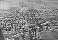
Aerial photo of Ankeny around 1958

See also
 In Spanish: Ankeny para niños
