
Geography of Iowa facts for kids
The geography of Iowa is all about the land, rocks, rivers, and even the history of the Earth in the state of Iowa. Iowa covers a large area, about 56,272 square miles (145,746 square kilometers).
Contents
Bedrock Features
The bedrock in Iowa is like the deep layer of solid rock under the soil. The age of this bedrock generally gets older as you go from west to east. In western Iowa, the rocks are about 74 million years old. But in eastern Iowa, they can be as old as 500 million years!
Meteor Impact Structures
Manson Impact Structure
About 74 million years ago, a huge asteroid crashed into what is now southeast Pocahontas County. This created a giant hole called the Manson crater. It was nearly 22 miles wide! This impact was so big it could have killed most animals within 650 miles. That's like from Denver to Detroit today!
People once thought this crash might have caused the dinosaur extinction. But scientists later found it happened about 12 million years before the dinosaurs disappeared. Today, you can't see any sign of this impact on the surface. That's because glaciers have covered it up over time. But the rocks deep underground are still unique because of it.
Decorah Crater

Another, much older, meteorite hit Iowa about 470 million years ago. This created the Decorah crater. It's estimated to be about 3.5 miles (5.6 km) wide. This crater is also hidden, covered by more than 50 feet of rock and soil. You can't see it from the surface.
This impact was very powerful, like 1,000 megatons of TNT! It pushed down the older rocks deep below. Scientists think this might have been one of several meteors that fell around the same time. This event is called the Ordovician meteor event.
Midcontinent Rift

Deep inside Iowa's bedrock is something called the Midcontinent Rift System. This is like a giant, ancient scar in the Earth's crust. It formed a billion years ago when the Earth's plates tried to pull apart but stopped. You can see it clearly on special magnetic maps of Iowa. This rift stretches from Kansas all the way to Lake Superior. Don't worry, it's not active anymore, so it won't cause earthquakes.
Earthquakes in Iowa
Iowa is one of the safest states when it comes to earthquakes. There are no major active fault lines here. Most of the time, Iowa doesn't feel any shaking.
Sometimes, small earthquakes happen near Fremont County in the southwest. The Sioux City area can also feel tiny tremors now and then. Very large earthquakes from the New Madrid Fault in southern Illinois and Missouri can sometimes be felt in eastern Iowa. Recently, earthquakes from Oklahoma have also been felt in Iowa. But none of these have caused any damage or injuries in Iowa.
Fossil Fuels

Long ago, Iowa was a big producer of coal. Many mines were found along the Des Moines River valley. Places like Boone and What Cheer were important in the late 1800s. Later, mines moved south to areas like Albia and Oskaloosa.
However, Iowa's coal has too much sulfur for today's uses. The last commercial coal mine closed in 1994. Iowa also has very little natural gas and oil.
Sioux Quartzite
In the far northwest corner of Iowa, in Lyon County, you can find a very old and hard rock called Sioux quartzite. This rock is a reddish-pink color. It's used a lot in the region for building roads and railroad beds. Sioux quartzite is incredibly old, formed between 1.64 and 1.76 billion years ago.
Geodes

Geodes are special rocks found in southeast Iowa. They are even the official state rock! Geodes look like ordinary grey or pink stones on the outside. But if you cut or break them open, you'll find a hollow space filled with sparkling crystals inside. They are very common around Geode State Park in Henry County.
Landforms and Topography


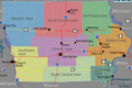
Even though many people think Iowa is flat, it's actually not! Most of the state has rolling hills. Geologists divide Iowa into eight main landforms. These are based on how glaciers shaped the land, the types of soils, and how rivers drain the area.
Paleozoic Plateau
This area is also called the Driftless Area. It has beautiful landscapes with high hills and deep, V-shaped valleys. You can find caves, springs, and sinkholes here. The layers of glacial dirt and fine soil (called loess) are very thin or missing in this region.
Des Moines Lobe

This area is often called the Prairie Pothole Region. Glaciers covered it until about 12,000 years ago. The land here has rolling hills and ridges. Long ago, this area had many small, connected swamps. Most of these were drained to create farmland. The Iowa Great Lakes are found on the western edge of this region.
Southern Iowa Drift Plain

This landform covers most of the southern half of Iowa. If you've driven on Interstate 80 through Iowa, you've probably seen this landscape. It's the classic Iowa view: rolling hills covered with rich soil. This area has some of the best farmland in the United States.
Mississippi Alluvial Plain

These are generally flat areas found along the wide Mississippi River valley. They include old river channels, wetlands, and oxbow lakes. These are lakes shaped like a U or C, formed when a river changes its course.
Loess Hills

The Loess Hills are found in far western Iowa. They are made of very thick layers of fine, wind-blown soil called loess. This soil was deposited during ancient ice ages. Over time, erosion has shaped these hills into unique, beautiful "golden hills."
Iowan Surface
Northeast Iowa has rolling hills made of old glacial deposits. It also has some loess, often forming long, low ridges called paha ridges. The hills are generally gentle, except near river valleys where they can be steeper. These scenic hills have been painted by famous artists like Grant Wood.
Northwest Iowa Plains
Like the Iowan Surface, the Northwest Iowa Plains have rolling hills. These are made of eroded soils that formed after ancient glaciers. This area also has a lot of loess.
Missouri Alluvial Plain
This is probably the only truly flat part of Iowa. The Missouri Alluvial Plain is found along the Missouri River. It has flat areas, wetlands, and oxbow lakes. The river channel here is narrower than the Mississippi River's. In Iowa, the eastern edge of the Missouri Plains meets the steep, rounded bluffs of the Loess Hills.
Climate

Iowa has a humid continental climate. This means it has very hot summers and very cold winters. The average yearly temperature in Des Moines is about 50°F (10°C). In the north, like Mason City, it's colder, around 45°F (7°C). In the southeast, like Keokuk, it's warmer, averaging 52°F (11°C).
Snowfall is common in winter. Des Moines gets about 26 days of snow each year.
Spring brings the start of severe weather. Iowa has about 50 days of thunderstorms each year. On average, Iowa sees about 47 tornadoes annually. In 2008, 12 people died from tornadoes in Iowa. This was the deadliest year since 1968. That year also had 105 tornadoes, matching the record from 2001.
Iowa summers are known for being hot and humid. Daytime temperatures can reach 90°F (32°C) and sometimes even over 100°F (38°C). Winters can be very cold, often dropping below 0°F (-18°C). Iowa's hottest temperature ever was 118°F (48°C) in Keokuk on July 20, 1934. The coldest temperature ever was -47°F (-44°C) in Washta on January 12, 1912.
Rainfall varies across Iowa. The southeast gets more rain, over 38 inches (97 cm) annually. The northwest gets less, under 28 inches (71 cm). Most rain falls in the summer months. January or February are usually the driest months. June is the wettest month because of frequent showers and thunderstorms. These storms can bring hail, strong winds, or tornadoes. In Des Moines, about two-thirds of the yearly rain falls from April through September. About half falls from May through August, with June being the peak.
Climate Data
| City | Jan | Feb | Mar | Apr | May | Jun | Jul | Aug | Sep | Oct | Nov | Dec |
|---|---|---|---|---|---|---|---|---|---|---|---|---|
| Davenport | 30/13 | 36/19 | 48/29 | 61/41 | 72/52 | 81/63 | 85/68 | 83/66 | 76/57 | 65/45 | 48/32 | 35/20 |
| Des Moines | 31/14 | 36/19 | 49/30 | 62/41 | 72/52 | 82/62 | 86/67 | 84/65 | 76/55 | 63/43 | 48/31 | 34/18 |
| Keokuk | 34/17 | 39/21 | 50/30 | 63/42 | 73/52 | 83/62 | 87/67 | 85/65 | 78/56 | 66/44 | 51/33 | 33/21 |
| Mason City | 24/6 | 29/12 | 41/23 | 57/35 | 69/46 | 79/57 | 82/61 | 80/58 | 73/49 | 60/37 | 43/25 | 28/11 |
| Sioux City | 31/10 | 35/15 | 47/26 | 62/37 | 73/49 | 82/59 | 86/63 | 83/63 | 76/51 | 63/38 | 46/25 | 32/13 |
| Climate data for Des Moines International Airport, Iowa (1981–2010 normals, extremes 1878–present ) | |||||||||||||
|---|---|---|---|---|---|---|---|---|---|---|---|---|---|
| Month | Jan | Feb | Mar | Apr | May | Jun | Jul | Aug | Sep | Oct | Nov | Dec | Year |
| Record high °F (°C) | 67 (19) |
78 (26) |
91 (33) |
93 (34) |
105 (41) |
103 (39) |
110 (43) |
110 (43) |
101 (38) |
95 (35) |
82 (28) |
69 (21) |
110 (43) |
| Mean maximum °F (°C) | 53.1 (11.7) |
59.1 (15.1) |
75.0 (23.9) |
84.0 (28.9) |
87.6 (30.9) |
93.2 (34.0) |
96.3 (35.7) |
95.2 (35.1) |
90.4 (32.4) |
82.4 (28.0) |
69.1 (20.6) |
55.8 (13.2) |
97.8 (36.6) |
| Mean daily maximum °F (°C) | 31.0 (−0.6) |
36.1 (2.3) |
49.0 (9.4) |
62.3 (16.8) |
72.4 (22.4) |
81.6 (27.6) |
85.7 (29.8) |
83.8 (28.8) |
76.1 (24.5) |
63.1 (17.3) |
47.9 (8.8) |
34.0 (1.1) |
60.4 (15.8) |
| Mean daily minimum °F (°C) | 14.3 (−9.8) |
18.8 (−7.3) |
29.7 (−1.3) |
41.1 (5.1) |
52.2 (11.2) |
62.0 (16.7) |
66.8 (19.3) |
64.8 (18.2) |
55.2 (12.9) |
43.0 (6.1) |
30.5 (−0.8) |
18.0 (−7.8) |
41.5 (5.3) |
| Mean minimum °F (°C) | −7.8 (−22.1) |
−4.1 (−20.1) |
9.5 (−12.5) |
23.7 (−4.6) |
37.6 (3.1) |
49.1 (9.5) |
56.3 (13.5) |
53.5 (11.9) |
38.0 (3.3) |
26.2 (−3.2) |
12.4 (−10.9) |
−3.6 (−19.8) |
−12.8 (−24.9) |
| Record low °F (°C) | −30 (−34) |
−26 (−32) |
−22 (−30) |
9 (−13) |
26 (−3) |
37 (3) |
47 (8) |
40 (4) |
26 (−3) |
7 (−14) |
−10 (−23) |
−22 (−30) |
−30 (−34) |
| Average precipitation inches (mm) | 1.00 (25) |
1.28 (33) |
2.30 (58) |
3.86 (98) |
4.74 (120) |
4.94 (125) |
4.47 (114) |
4.13 (105) |
3.05 (77) |
2.64 (67) |
2.19 (56) |
1.42 (36) |
36.02 (915) |
| Average snowfall inches (cm) | 8.5 (22) |
7.9 (20) |
5.2 (13) |
1.8 (4.6) |
0 (0) |
0 (0) |
0 (0) |
0 (0) |
0 (0) |
0.4 (1.0) |
2.5 (6.4) |
9.0 (23) |
35.3 (90) |
| Average precipitation days (≥ 0.01 in) | 7.5 | 7.8 | 9.7 | 11.2 | 12.5 | 11.5 | 10.1 | 9.1 | 8.4 | 8.9 | 8.3 | 8.4 | 113.4 |
| Average snowy days (≥ 0.1 in) | 6.5 | 5.6 | 3.2 | 1.0 | 0 | 0 | 0 | 0 | 0 | 0.3 | 2.0 | 6.2 | 24.8 |
| Average relative humidity (%) | 71.0 | 71.3 | 67.9 | 63.2 | 63.0 | 64.8 | 67.7 | 70.0 | 70.9 | 66.5 | 71.0 | 74.6 | 68.5 |
| Mean monthly sunshine hours | 157.7 | 163.3 | 206.0 | 222.2 | 276.0 | 312.1 | 337.8 | 297.9 | 239.8 | 210.0 | 138.5 | 129.2 | 2,690.5 |
| Percent possible sunshine | 53 | 55 | 56 | 56 | 61 | 69 | 73 | 70 | 64 | 61 | 47 | 45 | 60 |
| Source: NOAA (relative humidity and sun 1961−1990) | |||||||||||||
Water


In Iowa, like most places, you should never drink surface water without treating it first. Water from rivers and streams can have pollution from farms. This includes things like nitrates, chemicals, and animal waste. The Clean Water Act has helped improve water quality.
City water supplies are usually treated with chlorine. This chlorine, along with high nitrate levels, can sometimes make tap water smell strong. Also, because much of the state has limestone bedrock, the water is often "hard." Some cities use extra filters to make the water taste better. Des Moines, for example, has a very good water treatment system. Its water quality is ranked among the best in the country.
Jordan Aquifer
The Jordan Aquifer is a huge underground water source in Iowa. It stretches from northeast to south-central Iowa. This aquifer provides much of the water for farming and industries.
However, this important water source is facing problems. It's threatened by pollution and by being used too much. Farms use a lot of water for irrigation. Also, making ethanol uses a lot of water. When fields are tilled a lot, less rainwater soaks into the ground to refill the aquifer. Since the 1800s, the water level in the aquifer has dropped by as much as 300 feet. This has caused some wells to dry up and natural springs to disappear. It also affects water quality.
Soils
Iowa has 23 different types of soil regions. Generally, the soils in southern, eastern, and western Iowa come from loess (fine, wind-blown silt). The soils in northern and central Iowa come from till (materials left by glaciers). Most flat areas in Iowa have soils that are excellent for farming. This makes Iowa one of the most productive farming regions in the world.
Radon

Radon is a natural gas that can be a problem in Iowa, like in many states in the Midwest. It's especially common in areas with clay-rich soils. Radon levels are highest in the southern and western parts of Iowa.
Paleontology
Paleontology is the study of ancient life, like fossils.
Devonian Fossil Gorge
In 1993, big floods washed away soil and loose rock near the Coralville Lake Dam in Johnson County. This uncovered a rich collection of Devonian-age fossils. This area is now a visitor center where people can explore the ancient rock layers. Sadly, some people have illegally taken fossils from the site. The floods in 2008 actually made the fossil bed even bigger and exposed more fossils.
Dinosaurs
Rocks from the Jurassic and Cretaceous periods in western Iowa could potentially hold dinosaur remains. In nearby Nebraska, parts of "duck-billed" dinosaurs (called Hadrosaurids) have been found in similar rocks. However, thick layers of loess cover much of western Iowa. This makes it hard to find dinosaurs unless there are mining or quarrying operations.
Ancient Animals
Scientists have found many fossils of ancient animals in Iowa. These include animals from the Pleistocene and Holocene periods. These fossils help us understand what the environment was like in the Midwest long ago. Some of the first studies of ancient climates in the central U.S. were done using fossils found in Iowa.
For example, a giant sloth fossil is being dug up near Shenandoah, Iowa. So far, three individuals of Megalonyx jeffersonii, or Jefferson's Ground Sloth, have been found. This includes an adult and two younger sloths.
Notable Iowa Geologists
- Samuel Calvin (1840–1911) was Iowa's first systematic geologist. He helped create the first maps of Iowa's bedrock and landforms. Calvin Hall at the University of Iowa is named after him.
- Clair Cameron Patterson (1922–1995) was a scientist who figured out the age of the Earth. He calculated it to be 4.55 billion years old. This number was much more accurate than previous estimates and is still used today.
- Charles Rollin Keyes was another early Iowa geologist. He helped map the soils and bedrock in southeast Iowa. He also helped start the Iowa Geological Survey with Samuel Calvin.
Images for kids
-
Simplified map of Iowa
-
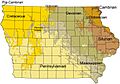
Bedrock formations of Iowa


