Paha (landform) facts for kids
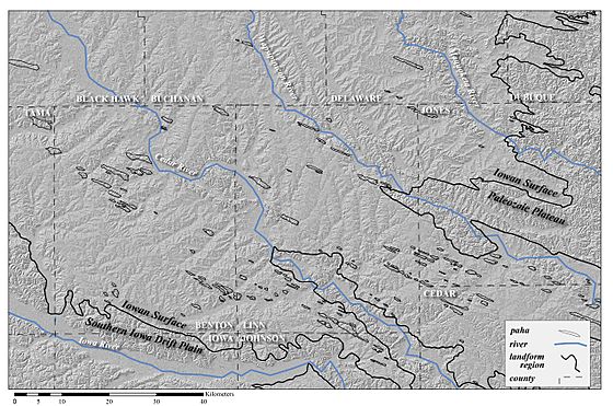
Paha (pronounced PAH-hah) are special hills found in places like Iowa. They are long, raised areas made mostly of loess (a type of fine, wind-blown dust) or a mix of loess and till (rocky soil left by glaciers). In Iowa, these hills usually point from northwest to southeast. They were formed when a lot of land was worn away by erosion, leaving these hills standing tall. Because they often have old, buried soils inside them, paha are like natural time capsules, showing what the land was like long ago. They usually rise more than 6.1 metres (20 ft) above the flat land around them. The word paha comes from the Dakota Sioux people and simply means "hill." Some well-known paha include the hill where the town of Mount Vernon, Iowa is built, Casey's Paha in Tama County, and the Kirkwood Paha, which is home to Kirkwood Community College. You can find similar hills in other parts of the United States and in Europe, where they are called greda.
Contents
How Paha Hills Formed
Paha hills were created during the last major Ice Age, known as the Wisconsinan period in North America. During this time, huge glaciers covered much of the land. As the glaciers melted, they released a lot of water and sediment, forming wide outwash areas along rivers. These outwash plains were a big source of fine dust, or loess, which was picked up and carried by strong winds.
The landscapes where paha are found were often gently rolling. This made it easy for wind-blown sediment to travel across the area, much like how sand moves in places like the Nebraska Sandhills. As wind carried sand, it would "saltate" (bounce and skip) across the ground. This bouncing sand would wear away the loess on the higher parts of the land. However, if there was something blocking the wind, like a steep river valley or a tall rock outcrop, the loess behind it would be protected.
This protection allowed loess to build up in certain spots, forming the beginnings of paha. As a paha grew taller, it changed how the wind blew around it. The hill would create swirling air currents, called eddies, on its downwind side. These eddies would slow the wind, causing even more loess to settle and build up behind the hill. This is why you often see several paha lined up in a row, downwind from a single natural barrier. In Iowa, it's thought that the rapid build-up of loess and the wearing away of the land happened at the same time during the Late Wisconsinan period. After the climate got warmer and the glaciers melted away, the landscape became more stable.
Paha Today
Paha in Iowa
In Iowa, the soils on paha hills are often forest soils or alfisols, which are good for growing trees. The land around the paha, however, usually has prairie soils or mollisols, which are rich and dark, perfect for grasslands. Today, most paha are still covered with trees or used for grazing animals. The flat land around them is often used for modern farming, growing crops like corn and soybeans.
Where to Find Paha
In the United States
You can find a clear line of paha hills between Mount Vernon and Martelle, Iowa. Iowa Highway 1 crosses right through this area. Most of these hills are in Benton, Linn, Johnson, and Jones counties.
Casey's Paha State Preserve in Hickory Hills County Park, Tama County, Iowa, protects the end of a paha that is about 2-mile (3.2 km) long.
Paha-like ridges have also been found in Kansas and in western Illinois. Similar ridge shapes appear in the dry, windy parts of the Palouse region in Washington. Outside the Midwest, some scientists use the term greda for these features, which are very similar to paha ridges.
In Europe
Hills similar to Iowa's paha are found in Europe, where they are called greda. For example, near Heidelberg, Germany, there are greda that form ridges along the River Rhine. These European greda have been dated to be between 40,000 and 34,000 years old.
 | Mary Eliza Mahoney |
 | Susie King Taylor |
 | Ida Gray |
 | Eliza Ann Grier |


