Tama County, Iowa facts for kids
Quick facts for kids
Tama County
|
|
|---|---|
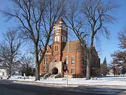
Tama County Courthouse in Toledo
|
|
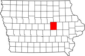
Location within the U.S. state of Iowa
|
|
 Iowa's location within the U.S. |
|
| Country | |
| State | |
| Founded | 1843 |
| Named for | Taimah |
| Seat | Toledo |
| Largest city | Tama |
| Area | |
| • Total | 722 sq mi (1,870 km2) |
| • Land | 721 sq mi (1,870 km2) |
| • Water | 1.1 sq mi (3 km2) 0.1% |
| Population
(2020)
|
|
| • Total | 17,135 |
| • Density | 23.733/sq mi (9.163/km2) |
| Time zone | UTC−6 (Central) |
| • Summer (DST) | UTC−5 (CDT) |
| Congressional district | 1st |
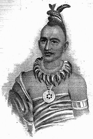
Tama County is a county in the state of Iowa, USA. As of 2020, about 17,135 people live there. The main town, or county seat, is Toledo. Tama County was created on February 17, 1843. It was named after Taimah, an important leader of the Meskwaki people.
Contents
Geography of Tama County
Tama County covers a total area of about 722 square miles. Most of this area, about 721 square miles, is land. Only a small part, about 1.1 square miles, is water.
Main Roads in Tama County
These are the most important roads that go through Tama County:
Neighboring Counties
Tama County shares its borders with these other counties:
- Grundy County (to the northwest)
- Black Hawk County (to the northeast)
- Benton County (to the east)
- Poweshiek County (to the south)
- Marshall County (to the west)
- Iowa County (to the southeast)
- Jasper County (to the southwest)
Population and People
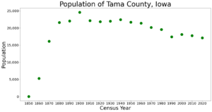
| Historical population | |||
|---|---|---|---|
| Census | Pop. | %± | |
| 1850 | 8 | — | |
| 1860 | 5,285 | 65,962.5% | |
| 1870 | 16,131 | 205.2% | |
| 1880 | 21,585 | 33.8% | |
| 1890 | 22,052 | 2.2% | |
| 1900 | 24,585 | 11.5% | |
| 1910 | 22,156 | −9.9% | |
| 1920 | 21,861 | −1.3% | |
| 1930 | 21,987 | 0.6% | |
| 1940 | 22,428 | 2.0% | |
| 1950 | 21,688 | −3.3% | |
| 1960 | 21,413 | −1.3% | |
| 1970 | 20,147 | −5.9% | |
| 1980 | 19,533 | −3.0% | |
| 1990 | 17,419 | −10.8% | |
| 2000 | 18,103 | 3.9% | |
| 2010 | 17,767 | −1.9% | |
| 2020 | 17,135 | −3.6% | |
| 2023 (est.) | 16,833 | −5.3% | |
| U.S. Decennial Census 1790-1960 1900-1990 1990-2000 2010-2018 |
|||
2020 Census Information
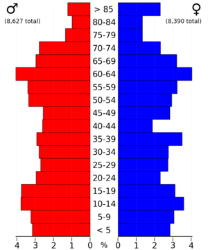
In 2020, the census counted 17,135 people living in Tama County. This means there were about 24 people for every square mile. Most people, about 93.80%, said they belonged to one race. There were 7,575 homes in the county, and 6,784 of them were lived in.
Here's a look at the different groups of people in Tama County in 2020:
| Group | Number of People | Percentage |
|---|---|---|
| White | 13,284 | 77.52% |
| Native American | 1,258 | 7.34% |
| Hispanic or Latino | 1,804 | 10.53% |
| Other groups (Black, Asian, Pacific Islander, Mixed) | 709 | 4.61% |
2010 Census Information
The 2010 census showed that 17,767 people lived in Tama County. There were 7,766 homes, and 6,947 of them were lived in.
Schools in Tama County
Tama County has several school districts that help educate students. There is also a special school for Native American students.
Here are some of the school districts:
- Belle Plaine Community School District
- Benton Community School District
- East Marshall Community School District
- GMG Community School District
- Gladbrook-Reinbeck Community School District
- Grundy Center Community School District
- North Tama County Community School District
- South Tama County Community School District
- Union Community School District
There is also the Meskwaki Settlement School, which is connected to the Bureau of Indian Education. This school serves the Meskwaki community. The largest school district in the county is South Tama Community School District.
Towns and Areas
Cities in Tama County
Other Communities
These are smaller communities that are not officially cities:
Townships
Tama County is divided into 21 smaller areas called townships:
- Buckingham
- Carlton
- Carroll
- Clark
- Columbia
- Crystal
- Geneseo
- Grant
- Highland
- Howard
- Indian Village
- Lincoln
- Oneida
- Otter Creek
- Perry
- Richland
- Salt Creek
- Spring Creek
- Tama
- Toledo
- York
Largest Towns by Population
This table shows the cities and communities in Tama County from largest to smallest, based on the 2020 census. The † symbol means it is the county seat.
| Rank | City/Town/etc. | Type | Population (2020) |
|---|---|---|---|
| 1 | Tama | City | 3,130 |
| 2 | † Toledo | City | 2,369 |
| 3 | Traer | City | 1,583 |
| 4 | Dysart | City | 1,281 |
| 5 | Sac and Fox/Meskwaki Settlement | Native American Area | 1,120 |
| 6 | Le Grand | City | 905 |
| 7 | Gladbrook | City | 799 |
| 8 | Garwin | City | 481 |
| 9 | Chelsea | City | 229 |
| 10 | Clutier | City | 213 |
| 11 | Montour | City | 203 |
| 12 | Elberon | City | 184 |
| 13 | Lincoln | City | 121 |
| 14 | Vining | City | 54 |
Famous People from Tama County
- George R. Struble (1836–1918): He was a judge and politician from Toledo. He served as the Speaker of the Iowa House of Representatives from 1881 to 1883.
- Michael Emerson: Born in Cedar Rapids and grew up in Toledo. He is a well-known actor who has performed on Broadway and appeared in TV shows like Lost.
- Clifford Berry (1918-1963): Born in Gladbrook. While studying at Iowa State University, he helped create the Atanasoff–Berry Computer (ABC) in 1939. This was the first electronic digital computer!
See also
 In Spanish: Condado de Tama para niños
 | Isaac Myers |
 | D. Hamilton Jackson |
 | A. Philip Randolph |


