Poweshiek County, Iowa facts for kids
Quick facts for kids
Poweshiek County
|
|
|---|---|

|
|

Location within the U.S. state of Iowa
|
|
 Iowa's location within the U.S. |
|
| Country | |
| State | |
| Founded | 1843 |
| Named for | Poweshiek, Meskwaki chief |
| Seat | Montezuma |
| Largest city | Grinnell |
| Area | |
| • Total | 586 sq mi (1,520 km2) |
| • Land | 585 sq mi (1,520 km2) |
| • Water | 1.1 sq mi (3 km2) 0.2% |
| Population
(2020)
|
|
| • Total | 18,662 |
| • Density | 31.846/sq mi (12.296/km2) |
| Time zone | UTC−6 (Central) |
| • Summer (DST) | UTC−5 (CDT) |
| Congressional district | 2nd |
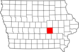
Poweshiek County is a county in the southeastern part of the U.S. state of Iowa. In 2020, about 18,662 people lived here. The main town, or county seat, is Montezuma.
The county is named after Chief Poweshiek, a leader of the Fox tribe. He signed an important agreement that ended the Black Hawk War. Poweshiek County is located along Interstate 80, a major highway between Des Moines and Iowa City. The biggest city in the county is Grinnell.
Contents
History of Poweshiek County
Poweshiek County was created in 1843. It was named after Meskwaki Chief Poweshiek (1791–1854). He was a respected leader of the Meskwaki people.
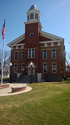
The Poweshiek County Courthouse was finished in 1859. This historic building is now listed on the National Register of Historic Places.
Who Runs Poweshiek County?
Counties have elected officials who help run things. Here are some of the people elected in Poweshiek County:
- County Supervisors: These people make important decisions for the county. The current supervisors are Chairman Jeff Tindle, Vice-Chair Jason Roudabush, and Jacki Bolen.
- County Attorney: Bart Klaver is the county attorney. This person is the main lawyer for the county.
- County Auditor: Missy Eilander helps manage the county's money and records.
- County Recorder: Lora Wyckoff keeps official records for the county.
- County Sheriff: Matt Maschmann is the chief law enforcement officer in the county.
- County Treasurer: Sandy Ross manages the county's funds and taxes.
Healthcare in Poweshiek County
Grinnell Regional Medical Center serves Poweshiek County. It is a hospital with 81 beds. The hospital was started in 1967 when two smaller hospitals joined together.
Geography of Poweshiek County
Poweshiek County covers about 586 square miles. Most of this area, about 585 square miles, is land. Only a small part, about 1.1 square miles, is water.
The county has several rivers and streams. The north fork of the Skunk River flows through the southwest part. The English River also drains parts of the county.
Main Roads
Several important highways pass through Poweshiek County:
 Interstate 80
 U.S. Highway 6
 U.S. Highway 63
 Iowa Highway 21
 Iowa Highway 85
 Iowa Highway 146
Public Transport
You can find information about bus stops in Iowa here: List of intercity bus stops in Iowa.
Neighboring Counties
Poweshiek County shares borders with these other counties:
- Tama County (to the north)
- Iowa County (to the east)
- Keokuk County (to the southeast)
- Mahaska County (to the south)
- Jasper County (to the west)
Population Information
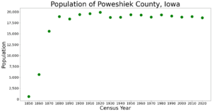
| Historical population | |||
|---|---|---|---|
| Census | Pop. | %± | |
| 1850 | 615 | — | |
| 1860 | 5,668 | 821.6% | |
| 1870 | 15,581 | 174.9% | |
| 1880 | 18,936 | 21.5% | |
| 1890 | 18,394 | −2.9% | |
| 1900 | 19,414 | 5.5% | |
| 1910 | 19,589 | 0.9% | |
| 1920 | 19,910 | 1.6% | |
| 1930 | 18,727 | −5.9% | |
| 1940 | 18,758 | 0.2% | |
| 1950 | 19,344 | 3.1% | |
| 1960 | 19,300 | −0.2% | |
| 1970 | 18,803 | −2.6% | |
| 1980 | 19,306 | 2.7% | |
| 1990 | 19,033 | −1.4% | |
| 2000 | 18,815 | −1.1% | |
| 2010 | 18,914 | 0.5% | |
| 2020 | 18,662 | −1.3% | |
| 2023 (est.) | 18,453 | −2.4% | |
| U.S. Decennial Census 1790-1960 1900-1990 1990-2000 2010-2018 |
|||
What the 2020 Census Showed

The 2020 census counted 18,662 people living in Poweshiek County. This means there were about 32 people for every square mile. Most people (96.55%) reported being of one race. There were 8,906 homes, and 7,536 of them were lived in.
What the 2010 Census Showed
The 2010 census recorded 18,914 people in the county. There were 8,949 homes, and 7,555 of them were lived in.
Education in Poweshiek County
Poweshiek County has three main public school districts:
| District | Main Town | Number of Schools |
Number of Students |
High School | District Website |
|---|---|---|---|---|---|
| BGM Community School District | Brooklyn | 1 | 532 | BGM | BGM |
| Grinnell–Newburg Community School District | Grinnell | 6 | 1,475 | Grinnell | Grinnell |
| Montezuma Community School District | Montezuma | 1 | 537 | Montezuma | Montezuma |
Poweshiek County is also home to Grinnell College. This is a small college that focuses on liberal arts. It was started in 1846.
There is one private school in the county called Central Iowa Christian School. It is located in Grinnell.
Towns and Communities
Cities
Other Communities (Unincorporated)
- Ewart
Census-Designated Places
- Holiday Lake
Population Ranking of Towns (2020 Census)
This table shows the population of cities and towns in Poweshiek County, from largest to smallest, based on the 2020 census.
† county seat
| Rank | City/Town/Place | Type | Population (2020 Census) |
|---|---|---|---|
| 1 | Grinnell | City | 9,564 |
| 2 | Brooklyn | City | 1,502 |
| 3 | † Montezuma | City | 1,442 |
| 4 | Victor (mostly in Iowa County) | City | 875 |
| 5 | Holiday Lake | CDP | 473 |
| 6 | Malcom | City | 270 |
| 7 | Deep River | City | 249 |
| 8 | Barnes City (partially in Mahaska County) | City | 156 |
| 9 | Searsboro | City | 129 |
| 10 | Hartwick | City | 92 |
| 11 | Guernsey | City | 63 |
See also
 In Spanish: Condado de Poweshiek para niños
 | Janet Taylor Pickett |
 | Synthia Saint James |
 | Howardena Pindell |
 | Faith Ringgold |


